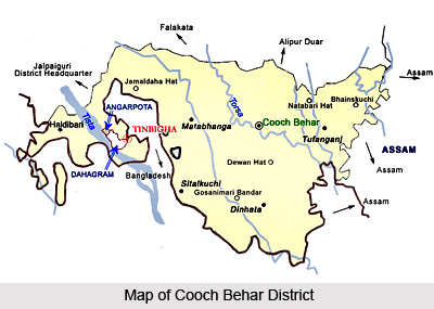
 Cooch Behar district is located in the north-western part of the state of West Bengal. It lies between 26 degrees 36 minutes and 25 degrees 57 minutes north latitude and between 89 degrees 54 minutes and 88 degrees 47 minutes east longitude. It is surrounded by the district of Jalpaiguri in the north and north-west, state of Assam in the east (bounded by the districts of Kokrajhar and Dhubri in Assam) and the International Border in the form of Indo-Bangladesh boundary in the south and south-west. Beside this bounded area there are enclaves (called Chhits) which are outlying and detached tracts of land situated inside Bangladesh. There are 110 such Chhits. The district occupies a total area of 3387 Sq. Kms, which makes up 3.82 percent of the landmass of the state of West Bengal. Of this, the total agricultural area is 2530.63 Sq. Kms.
Cooch Behar is essentially a flat country with a slight south-eastern slope along which the main rivers of the district flow. Most of the high land lies in the Sitalkuchi area and most of the low lands lie in Dinhata area. The pre-dominant soil found here is alluvial soil of very recent formation. It is mostly sandy and loose. The surface soil is loam and hardly any good clay is found. The rivers flow in a slanting course from north-west to south-east. Six river systems cut through the district flowing in a south-easterly direction. From the west to east these are: the Teesta river system, Jaldhaka river system, Torsa, Kaljani, Raidak River and Gadadhar system.
The climate of the district is characterized by a very high level of humidity and abundant rainfall. The temperature is hardly ever excessive. The South-West monsoon season falls in the period between June and the beginning of October. October to mid-November constitutes post-monsoon season, and winter falls between November and February. January is the coldest month with temperature varying between 10.4 degree Celsius to 24.1 degree Celsius April is the hottest month with a mean daily maximum of 32.5 degree Celsius and mean daily minimum of 20.2 degree Celsius. The atmosphere is highly humid throughout the year except February to May when relative humidity is as low as 50 to 70 percent. The average rainfall in the district is 3, 2013 mm. The rainfall generally increases from the south-west to the north-east. About 70 percent of the annual rainfall is received during the southwest monsoon season, June being the rainiest month. On an average there are about 102 rainy days with records of more than 400 mm rainfall in 24 hours.
The Cooch Behar district is mainly agricultural in nature, and the economy is dependant on the same. Among the major crops grown here are cereals like wheat, rice and pulses. Animal resource farming and dairy activities are also practiced here. The total forest area of the district is about 56.99 square kilometers. The flora here constitutes, among others, palms, bamboo, creepers, ferns, orchids, aquatic plants, fungi, timber, grass, vegetable, fruit trees, etc.


