 Geography of Changlang district includes its climate, flora, fauna, and physiographic divisions. The climatic conditions of this district of Arunachal Pradesh differ from place to place due to mountainous terrain.
Climate of Changlang District
The altitude of the Changlang District also varies from 200 meters to 4500 meters over the peaks from sea level. The places like Miao, Kharsang, Jairampur, Bordumsa and Diyun, which are located in lower elevations and in the valleys, experience hot and humid climate in summer during June-August. In the hill areas, the climate is moderate and pleasant. December to February months are cold. January is the coldest month when the average maximum and minimum temperature is about 22 degree Celsius and 13 degree Celsius respectively. August is the hottest month during which temperature may occasionally exceed 30.2 degree Celsius. The average maximum temperature is about 26.96 degree Celsius and minimum 18.63 degree Celsius. The rainfall is also very much influenced by the terrain. There is sharp difference in the quantity of rainfall at different places. The annual rainfall ranges from 3800 mm to 4866 mm. The major rainfall is received during June to October.
Rivers of Changlang District
The major rivers are Noa-Dehing, Namchik and Tirap. Other rivers are Namphuk, Dapha, Namphai, Tissu, Tarit, Tara, Tikeng, and Tiging. Most of the rivers after winding through the hills and valleys come down to the plains and join Buri-Dihing River. The Noa-Dihing River, which originates from Patkai Hills or Purvanchal Ranges, flows east to west through the entire north-eastern and northern stretch of the district. The Tirap rises from a high peak between Laju and Wakka and flows Southwest to Northeast passing through the Changlang town ultimately meet Buri-Dihing near Lekhapani in Assam. These rivers become turbulent during the monsoon and cause a great damage to agriculture fields in the area but at the same time increases the fertility of the soil by depositing silt along their courses
Natural Vegetation of Changlang District
The natural vegetation of Changlang district is very rich. Most of the plants are of tropical and sub-tropical wet evergreen and semi-ever green variety in the lower reaches; mixed deciduous forest in the middle and temperate forest in the hills. The valuable timber species available are Hollock (Terminalia myriocarpa), Hollong (Dipterocarpus macrocarpus), Mekai (Shorea assamica), Jutuli, Dhuna, Michelia Champaka, Oak, Betula and so on. One of the rarest and endangered Orchids, Blue Vanda is found in Namdapha.
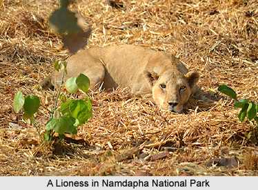
Wildlife of Changlang district
Wildlife of Changlang district is rich and varied. Among the important animals Royal Bengal Tiger, Clouded Leopard, Elephant, Gaur, Sambar, Malayan Sambar, Wild Boar, Lesser Panda, Slow Loris etc. The Hoolock Gibbon, the only ape in India is now found in the Namdapha Tiger Reserve. Besides, there are a large number of arboreal animals, mainly 5 species of monkey and six species of squirrels including the giant flying squirrels.
There is a great variety of birds. The most common bird is the great Hornbill. Other interesting birds are Kaleej pheasant, Fragopan, forest eagle, Monal pheasant, peacock, bulbul, woodpecker, dove, pigeon, etc. White winged wood duck, a rare and endangered species is also occasionally seen in the Namdapha forests. During winter, migratory birds such as ducks, gees, teals, swallows, wagtails, finches and others also visits the rivers, streams and pools.


