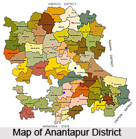
 Anantpur district lies between 13`-40` and 15`-15` Northern Latitude and 76`-50` and 78`-30` Eastern Longitude. It is bounded by Bellary district and Kurnool district on the North, by the Cuddapah and Kolar districts of Karnataka on the South-East and North respectively. The district is roughly oblong in shape, the longer side running north to South with a portion of Chitradurg District of Karnataka State intruding into it from west between Kundurpi and Amarapuram Mandals.
The District may be divided into 3 Natural Divisions. They are:
1) Northern Mandal of Rayadurg, Kanekal, Beluguppa, Gooty, Guntakal, Vajrakarur, Uravakonda, Vidapanakal, Yadiki, Tadipatri, Putlur and Yellanur containing larger areas of Black Cotton soils
2) Kalyandurg, Kambadur, Settur, Brahmasamudram, Ramagiri, Kanaganapalli, C.K.Palli, Dharmavaram, Bathalapalli, Tadimarri, Mudigubba, Anantapur, Kudair, Pamidi and Peddavadugur in the centre which are mainly made up of arid, treeless, expanse of poor Red Soil.
3) High Level Land of Penukonda, Roddam, Somandepalli, Hindupur, Lepakshi, Chilamathur, Madakasira, Rolla, Gudibanda and Agali which connects with Mysore plateau at higher elevation of the rest of the district. This part has average sandy red soils of normal productivity.
Running from the North of Gooty town up to the extreme Southern corner of Tadipatri and Yadiki Mandals for a length of about 35 kms are the Muchukota Hills. Another line of hills, the Nagasamudram hills starts from West of Gooty Mandal and runs for a length of 80 kms. The Mallappakonda Range begins at Dharmavaram and runs into Karnataka State. The Penukonda Range which starts in the South of Dharmavaram through Penukonda and Hindupur proceeds to Karnataka State. In Madakasira, the hills divide Rolla and Agali Mandals into Southern and Northern portions. There are numerous isolated Peaks and Rocky Clusters which are devoid of any vegetation. The forests in the Anantpur district are thin and scanty.
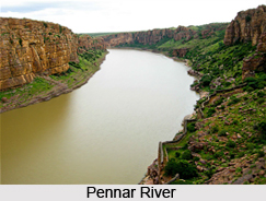
Among the various rivers running in the district the most important is the Pennar River. It has its origins in the Nandi Hills of the state of Karnataka. It enters the Anantpur district from the extreme South of Hindupur Mandal and flows through Parigi, Roddam, Ramagiri, Kambadur, Kalyandurg, Beluguppa, Uravakonda, Vajrakarur, Pamidi, Peddavadugur, Peddapappur and Tadipatri Mandals and finally enters Cuddapah District. The Jayamangala River, which has its origins in Karnataka, enters the district through the Parigi Mandal and joins Pennar River at Sangameswarampalli of Parigi Mandal. Another important river in the district is the Chitravathi, which also originates in Karnataka State. This river enters the District near Kodikonda village of Chilamathur Mandal and flows North over the rocky and hilly upland before falling into the Pennar River at Gandikota in Cuddapah District. The Vedavathi River flows through Gummagatta, Brahmasamudram, Beluguppa, Kanekal and D.Hirehal Mandals and enters Bellary District of Karnataka State. The Bhairavanithippa project has been constructed on this river. Apart from these streams like Kushavathi in Chilamathur Mandal, Swarnamukhi in Agali Mandal, Maddiler in Nallamada, Kadiri and Mudigubba Mandals, Pandameru in Kanaganipalli, Raptadu, Anantapur B.K.Samudram and Singanamala Mandals, Papagni in Tanakal Mandal are important water supply sources to various large and medium irrigation tanks in the district.
 The climate of Anantpur district is tolerable throughout the year, which is a result of the fairly good elevation of the district. The topography of the land is such that it has a gradual fall from the South North towards the valley of the Pennar in Peddavadugur, Peddapappur and Tadipatri Mandals. There is a gradual rise in Hindupur, Parigi, Lepakshi, Chilamathur, Agali, Rolla and Madakasira Mandals in the South to join the Karnataka Plateau where the average elevation is about 2000 feet above the mean sea level. It is about 1100 feet at Anantapur and the lowest 900 feet is at Tadipatri. The geographical position of the peninsula is such that it renders the place as the driest part of the state. As a result of this, agricultural conditions too are rather precarious. Being far from the East coast, it does not enjoy the full benefits of North East Monsoons and being cut off by the high Western Ghats mountain range, the South West Monsoon is also prevented from penetrating these parched soils. It is therefore seen that the district is often deprived of the monsoons and subjected to droughts due to bad seasons. The normal rainfall of the district is 553.0 mms, which means that it secures least rainfall when compared to Rayalaseema and other parts of Andhra Pradesh. The normal rainfall for the South West Monsoon period is 338.0 mms which forms about 61.2% of the total rainfall for the year. The rainfall for North East monsoon period is 156.0 mms only, which forms 28.3% mms of the total rainfall for the year (October to December). The other months are almost dry. March, April and May are warm months when the normal daily maximum temperature ranges between 29.1 C to 40.3 C. November, December and January are cooler months when the temperature falls about 15.7 C, Hindupur, Parigi, Lepakshi, Chilamathur, Agali, Rolla and Madakasira Mandals being at High Elevation are cooler than the rest of the Mandals in the District.
Most of the soil at Anantapur district is Red soil. Exceptions are found at Kanekal, Bommanahal, Vidapanakal, Uravakonda, Vajrakarur, Guntakal, Gooty, Pamidi, Peddavadugur, Yadiki, Tadipatri, Yellanur, Peddapappur and Putlur mandals where red and black soils occur in almost equal proportion.
Among the various mineral resources occurring in the area, the chief resources are gold, diamonds and asbestos. There are however no large sized minerals occurring in the district.


