 Dimapur was upgraded from Sub-division to full fledged District in December 1997. The district consists of Dimapur and Niuland sub-divisions, bifurcated from Kohima. The proposed headquarters for the District is at Chumukedima. At present, the headquarter is situated at Dimapur town. The District is bounded by Kohima district on the south and east, Karbi Anglong district of Assam on the West. The DAB (Disputed Area Belt) in the north borders Golaghat district of Assam.
History of Dimapur
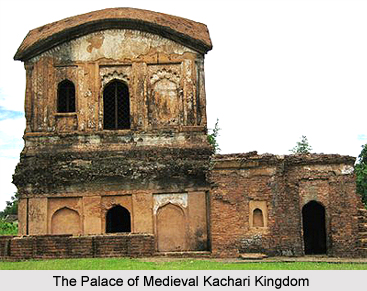
The ancient Kachari capital Dimapur is one of the important sites of megalithic culture. Most of the ruins appear to be contemporaries with the Kachari civilisation, established before the Ahom invasion in the 13th Century A.D. There is evidence of a touch of Hindu art and architectural influence on most of them, though these are predominantly non-Aryan, with elaborate rituals and the cult of fertility. Besides the Monolithic, the ancient Kachari capital Dimapur contains other ruins of temples, embankment and tanks. The entrance gateway has been beautifully executed and is in good preservation till the present time. There are still scattered blocks of stone and brick pieces with various designs.
Geography of Dimapur
A large area of Dimapur is the plain land . It has an average elevation of 260 meter above sea level excepting the Medziphema sub-division and a few villages of Niuland sub-division, which are located in the foothills. The total area of Dimapur is 927 sq. km. This district is bounded by Kohima District on the East; Peren District on the south ; the Karbi Anglong and the DAB (Disputed Area Belt) stretch of Golaghat District of Assam, in the west . It has an extension of 25 degree and 54 minutes and 45 seconds North Latitude and 93 degree 44 minutes and 30 seconds East Longitude.
Demography of Dimapur
According to the Populatin Census in India in the year 2011, Dimapur has a population of 375,782. Males constitute 57% of the population and females 43%. Dimapur has an average literacy rate of 69 percent, much higher than the national average of 59.5 percent. The male literacy rate is 76 percent and, female literacy rate is 66 percent. In Dimapur, 13 percent of the population is under 6 years of age.
Tourism in Dimapur
Chumukedima
It is situated just about 14 Km from Dimapur on National Highway 39. This place served as the first headquarters of the then Naga Hills District of Assam State during the time of British rule in early 19th centure. The Department of Tourism is constructing a Tourist Village on top of a hill. From this spot, one can view the whole of Dimapur and other parts of Karbi-Anlong of Assam. The Tourist Village is at a distance of 8 Km from the National Highway. Few waterfalls are also located in this area, which are under exploration and assessment for easy approach.
Intanki Wildlife Sanctuary
The Intanki Wildlife Sanctuary lies at a distance of 37 Km from Dimapur. The Sanctuary is under the preservation of the Forest Wildlife Department. Habitat of various animals including some rare species of birds.
Dimapur is the only Airport in Nagaland. Indian Airlines, NEPC Airlines Boeing, Vayudoot Services are operating everyday both from Delhi and Kolkata. The National Highway 39 is passing through the heart of the town. Kohima is just 74 km distant from Dimapur, which one can cover in just 2 hours. State Transport Services, Private Buses and Taxis are also available at any time. Many Private Night Super Tourist Buses are also plying from Dimpaur to various important cities and towns in the Northeast.


