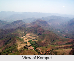
 Koraput is place of tourist importance with her rolling mountains, undulating meadows, roaring rapids, enchanting waterfalls and terraced valleys leading up to verdant hills, feasts the eyes as few other districts can. Koraput town is known associated with agricultural basis, but also due to its rich history from Vedic era, Koraput has the rich tourist destination. One can reach Koraput by reaching Vishakhapatnam Airport in Andhra Pradesh not by Bubhaneshawar Airport of Odisha.
Location of Koraput
Koraput is located at 18.82 degree North to 82.72 degree East. It has an average elevation of 870 metres (2854 feet).
Geography of Koraput
Koraput with her golden autumn and misty mornings of the monsoon months, her painted spring and slumbering summer and her winter ranging from fierce to mild provides varieties of living in different seasons which is rare elsewhere. Here in spring, nature and man vie with each other to make living joyous. Some major rivers of Odisha pass through the district Koraput like Machhakunda, Vamsadhara and Kolab. This town is also bestowed with waterfalls like Duduma falls, Bagra falls and Khandahati falls. It also contains the largest mountain of Odisha, called Deomali along with Chandragiri Mountain. Koraput district is famous for the important places like Jeypur, Duduma, Bagra, Sunabeda MiG factory etc. Koraput holds a total area of 8,807 square kilometres.
Demography of Koraput
The total population of Koraput is of 13, 79,647. The district has a literacy rate of 36.20%. Koraput is dependent on agricultural activities.
Economy of Koraput
Koraput has total cultivable land of 3, 01,000 hectares. With a 157 km long national highway the district is well connected to all the other districts of Odisha.
Tourism in Koraput
Koraput has the vast tourist opportunities like Savara Shrikhetra, Duduma Waterfall, Machkund falls, Ankadeli Village, Gupteswar Temple, Dumuriput, Nandapur, Semiliguda Village, Kolab Dam, Maliguda, Bagra falls and Khandahati falls.
Visiting Information
Koraput is connected with all major railways, roadways and airways. The nearest airport is at Visakhapatnam. The trains are well connected from Visakhapatnam, Bhubaneswar, Delhi, Chennai and Kolkata. The road transport facilities are available at NH43 that passes through the District.
Related Articles
Odisha
Temples of Odisha
Districts of Odisha
Puri, Odisha
Lulung, Odisha
Forts in Odisha
Crafts of Odisha
Beaches of Odisha
Cities of Orissa


