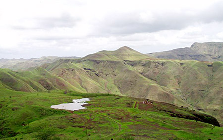
 Barwani is situated in the state of Madhya Pradesh, India. The town rests on the left bank
of the Narmada River. Barwani is the administrative headquarters of the Barwani District and earlier served as the capital of the former princely state of Barwani. Barwani is located at 22.03° N 74.9° E and has an average elevation of 178 metres. Barwani is surrounded by great hills of satpura. River Narmada flows through this state. The place is situated on the southern side of Madhya Pradesh as well as holy river Narmada. The district is surrounded by Satpuda on the South and Vindhyachal forest ranges in the North, Maharashtra State on its South Gujarat in far West, district Khargone on the East and district Dhar on the North form boundaries of Barwani. District is triangular in shape with the highest point in West. Gujarat in far West, district Khargone on the East and district Dhar on the North form boundaries of Barwani. District is triangular in shape with the highest point in West. The temperature of Barwani in April & May goes as high as 48`C, which makes it hottest place in India.
Barwani is situated in the state of Madhya Pradesh, India. The town rests on the left bank
of the Narmada River. Barwani is the administrative headquarters of the Barwani District and earlier served as the capital of the former princely state of Barwani. Barwani is located at 22.03° N 74.9° E and has an average elevation of 178 metres. Barwani is surrounded by great hills of satpura. River Narmada flows through this state. The place is situated on the southern side of Madhya Pradesh as well as holy river Narmada. The district is surrounded by Satpuda on the South and Vindhyachal forest ranges in the North, Maharashtra State on its South Gujarat in far West, district Khargone on the East and district Dhar on the North form boundaries of Barwani. District is triangular in shape with the highest point in West. Gujarat in far West, district Khargone on the East and district Dhar on the North form boundaries of Barwani. District is triangular in shape with the highest point in West. The temperature of Barwani in April & May goes as high as 48`C, which makes it hottest place in India.
Origin of name of Barwani
The name Badwani originated from the forests of `bad` which had sorrounded the city in old times, and `wani` means Garden. Therefore the name of the city meand `garden of bad`. Barwani is still pronounced as Badwani but it spells Barwani.
History of Barwani
It is said that Barwani lost most of its territory during the Maratha invasion in the 17th century. Under the clutches of the British Raj, Bharwani was a state of the Bhopawar agency, which is a division of the Central India Agency. The forest regions were under a British official. Before 1948, Barwani was the capital of old Barwani State. The Rana dynasty ruled the state throughout the history. This small State was spared by British, Moughals and Marathas because of its rocky tarrain and less productive soil.
In 1947, after India`s independence Barwani became part of the Nimar District of Madhya Bharat state. Eventually on November 1, 1956, Madhya Bharat was merged into Madhya Pradesh. The district of Barwani was formed on 25th May 1998. It was carved out of West-Nimar, Khargone district.
Divisions of Barwani
The district of Barwani consists of 2 sub-divisions as Barwani and Sendhawa which are further divided into 6 tahsils namely Barwani, Sendhawa, Pansemal, Niwali, Thikari and Rajpu. The two municipalities of Barwani are Barwani and Sendhawa.
Barwani district has 417 panchayats and 646 villages, 576 revenues. Out of the 646 villages, 560 are inhabitated and 16 are un-inhabitated.
Demography of Barwani
As per 2001 census, Barwani had a population of 73,222. Males constitute 52% of the population and females 48%. Barwani has an average literacy rate of 67%, higher than the national average of 59.5%; with 57% of the males and 43% of females literate.
Places of interest in Barwani
Anjad, is an important commercial place.
Veereshwar Mahadev and Nagari Mata Temples
Bawangaja is an important Jain pilgrimage centre.
Barwani, the headquarter of the district is another important town of the district which is famous commercially as well as for its old monuments.
Bhawar Garh houses the ancient fort of Bhawar Garh or Borgarh
Beejasan is famous for the temple of Godess Beejasani (Durga).
Sendhawa is famouse for cotton ginning factories. It is a big commercial centre of the area.
Transport of Barwani
Barwani district is not well connected via rail, and air transport services. Any way it has goood road connectivity. The nearest airport at Barwani is Devi Ahilyabai Holkar Airport(Indore) which is 150 KM from Barwani. This airport provides connectivity to important cities like Mumbai, Delhi, Ahmedabad, Hyderabad, Kolkata, Raipur and Nagpur. The nearest railway station is also at Indore. Barwani is well connected to other parts of Madhya Pradesh and India with national and state highways. There are bus services to and from all major and minor cities near Barwani.
Education of Barwani
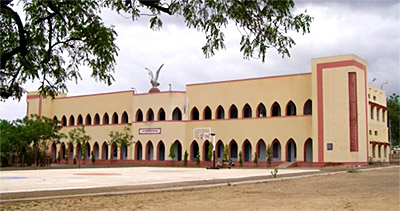
There are many schools and colleges at Barwani. The important institutions of Barwani are:
•Industrial Training Institute, Barwani
•District Institute of Education Training, Barwani
•Govt. Post Graduate College, Sendhawa
•Govt. Polytechnic, Barwani
•Girls Higher Secondary School, Barwani
•Model School, Barwani
•Govt. Girls College, Barwani
•Kastoorba Girls Tribal Ashram Niwali


