Introduction
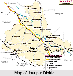 Jaunpur District is situated in the north-west part of Varanasi Division of Uttar Pradesh. This district extends from 24.24 degree north to 26.12 degree north latitude and between 82.7 degree east and 83.5 degree east longitude. Average altitude of Jaunpur District varies from 261 feet to 290 feet above the mean sea level. The geographical area of Jaunpur District is 4038 sq kms. According to 2001 census, total population of Jaunpur District is 39,11,305, in which female population is 19,75,729 and male population is 19,35,516. Jaunpur town is the district headquarters.
History of Jaunpur District
 According to the history of Jaunpur District the continuous existence of this region can be seen till Late Vedic Period. The district was a major pious ground for meditations and contemplations of sages, Rishis and Maharshis. According to the history, the first arrival in this district was of Raghuvanshi Kshatriyas. In this district, early inhabitants were the Bhars and the Kshatriyas began to have conflicts with them. During the Sharqi period, many grand buildings, mosques and mausoleums were built here. Firoz Shah Tughlaq had laid the foundations of the Atala Mosque in 1393 AD but it was completed by Ibrahim Shah Suri in 1408 AD.
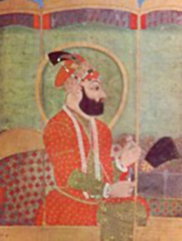
As per the history of Jaunpur District, Lodhi Dynasty ruled the throne of Jaunpur from 1484 AD to 1525 AD. In 1526 AD Babur attacked Delhi and defeated Ibrahim Lodi in the first battle of Panipat. To conquer Jaunpur, Babur sent his son Humayun, who defeated the ruler of Jaunpur. It was during the reign of Akbar that the `Shahi Pul` of Jaunpur was built.
According to scholars Jaunpur had also been influenced by Buddhism. In 1722 AD after being a part of the Mughal Sultanate for a century and a half, Jaunpur was entrusted to the Nawab of Awadh. Further, later in 1775 AD Jaunpur too, along with Banaras went into the hands of the British rulers. From 1775 AD to 1788 AD Jaunpur was under the dominion of Banaras. In 1818 Jaunpur became a separate district. In 1820, Azamgarh District was also brought under Jaunpur but whole of Azamgarh in 1830 was separated from Jaunpur.
History of Jaunpur District also says about the contribution of Jaunpur District in the freedom struggle of the country. During the British period Jaunpur District has been a witness of the rebellion against the power of the state. In the year 1885, Indian National Congress was established. In the Non Cooperation Movement of Mahatma Gandhi in 1920, Jaunpur took part with dedication and zeal. During this period Motilal Nehru, Sarojini Naidu, Jawaharlal Nehru, Madan Mohan Malviya, also visited the district and meetings were organized. In October 1929, Mahatma Gandhi too visited Jaunpur. Rebellion under the Quit India Movement started in the district on 10th of August, 1942. Thus, in this way Jaunpur District had played an important role in the freedom struggle against the British rulers.
Geography of Jaunpur District
Topography of Jaunpur District mainly includes flat plain with shallow river-valleys. Gomti River and Sai River are the main rivers flowing through the district. Soils of the district are mainly sandy, loamy and clayey. There is a scarcity of minerals in Jaunpur District. The temperatures of this district lie between a minimum of around 4 degree Celsius and a maximum of near about 44 degree Celsius. Average annual rainfall in Jaunpur District is 987 mm.
Economy of Jaunpur District
The economic development of Jaunpur District is mainly dependent on agriculture. Three fourths of the population of the district of Jaunpur is dependent on agriculture. The chief cause of this is the absence of heavy industries. However, several industries are coming up along Varanasi Jaunpur highway. A cotton mill is operational near Karanja Kala. Animal husbandry also constitutes a sector of economy of Jaunpur District.
Administration of Jaunpur District
From the administrative point of view, Jaunpur District has been divided into six tehsils in order to maintain law and order and for proper implementation of the developmental works. The six sub-divisions of this district are Sadar, Madiyahun, Machhalishahar, Kerakat, Shahganj and Badlapur. Further, administrative set-up of Jaunpur District has been divided into 21 Development Blocks - Sondhi (Shahganj), Suithakala, Khutahan, Karanja Kala, Badlapur, Maharajganj, Sujanganj, Baksha, Mungrabadshahpur, Machhalishahar, Madiyahun, Barsathi, Rampur, Ramnagar, Jalalpur, Kerakat, Dobhi, Muftiganj, Dharmapur, Sikrara and Sirkoni. Jaunpur District has been divided into 27 police stations - Kotwali, Sadar, Line Bazar, Jafrabad, Khetasarai, Shahganj, Sarpatahan, Kerakat, Chandwak, Jalalpur, Sarai Khwaja, Gaurabadshahpur, Badlapur, Khutahan, Singramau, Baksha, Sujanganj, Maharajganj, Mungrabadshahpur, Pawara, Machhalishahar, Mirganj, Sikrara, Madiyahun, Rampur, Barsathi, Nevadhiya and Sureri. District Magistrate is the head of administration of Jaunpur District.
Monuments of Jaunpur
 The monuments of Jaunpur were an example of manifestation of Indo-Islamic architecture of considerable distinction. Jaunpur, 58 km or 36 miles from Varanasi, is an ancient city, the former capital of a substantial Muslim kingdom which flourished between 1397 and 1476 under the Sharqi dynasty. The most notable characteristics of this particular style are the use of the arched pylon in the centre of the facades, two-storey arcades, huge gateways and the unifying use of the depressed four-centered arch with a fringe of ornament.
The origins of the Jaunpur architectural style may well be found in the village of Zafarabad, 6-5 km outside the city. Here the Mosque of Shaikh Barha is an early, rather crude, improvisation using materials taken from Jain temples in the vicinity. The hypostyle hall has a roof carried by a veritable forest of over sixty columns, but the massive front displays the rudimentary pylon form, which was to become one of the hallmarks of the architecture of the Sharqi dynasty.
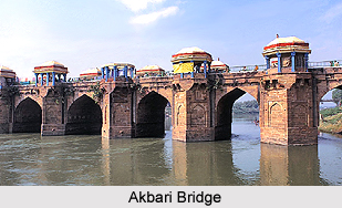
From Zafarabad the road into Jaunpur leads to River Gumti via the massive Akbari Bridge built by Munim Khan who was the local governor in the kingdom of Akbar. The Afghan architect, Afzal Ali, created a splendid structure 200 m long with fifteen arches, the central four being larger than the outer spans. It was damaged by floods in 1773 and 1871. The pavilions crowning the piers were restored in 1887. Further damage occurred during an earthquake in 1934. At the south end of the bridge a large stone lion, depicted seizing an elephant, was the provincial milestone from which distances were calculated.
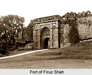
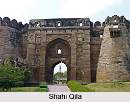
The Fort of Firuz Shah is an irregular quadrangle overlooking the north of the Gumti. It comprises a stone wall around an earth mound which utilizes earlier masonry inscribed with Hindu motifs. Most of the towers were blown up after the 1857 Mutiny but the entrance gate constructed by Munim Khan still survives. Remnants of its original cladding of blue and yellow glazed brick are still visible.
 About 62 m beyond the entrance gate is a large reservoir with a low mosque beyond, built in 1376 by Ibrahim Naib Barbak, brother of Firuz Shah Tughluq. Between the mosque and the river wall, above the surrounding countryside, is a round magazine tower with the Hammam or baths of Ibrahim on the left.
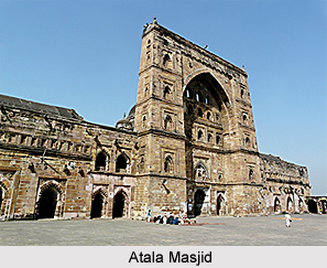
The Atala Masjid lies about 366 m north of the Akbari Bridge. Built by Sultan Ibrahim Sharqi on the site of the old Hindu temple at Atala Devi, the mosque incorporates a great deal of temple masonry. It comprises a square courtyard, with three cloistered ranges, the fourth side being the sanctuary. The cloisters are with five aisles rising to two storeys, two aisles of the lower storey forming cells with a pillared verandah facing the street. These provided external accommodation for travellers or merchants. In the centre of each range is a gateway. However, the most impressive clement is the sanctuary on the western side. It has an elegant, original facade, dominated by a central pylon with a huge arched marble mihrab or recess containing the entrance to the nave and arcaded window openings. On either side are smaller structures, providing a symmetrical frame. The courtyard is paved to resemble a prayer carpet.
Immediately behind the central pylon is the dome, which is ribbed internally and carried on an arcaded triforium. The transepts extending each side of the nave are long pillared halls, which open into an octagonal bay or side chapel crowned by a smaller dome.
Externally, the juxtaposition of the dome and the pylon is somewhat incongruous, but the mosque is a remarkably vigorous development of provincial style, using many elements derived from the architecture of the Tughlaqs at Delhi - in particular, the sloping sides of the pylons and the fringe ornamentation of the central arch. It is probable that many of the workmen trained in Delhi under Firoz Shah Tughluq were pressed into service by the Sharqi rulers. The persons responsible for directing the great works at Jaunpur in such a wholly inventive way is not known, but the resulting architectural synthesis is beautiful.
 Two further mosques were built about in 1430: the Khalis Mukhlis Masjid and the Jhanjiri Masjid are among the popular architectural edifices of Jaunpur. The former is a plain, austere edifice modelled on the Atala Masjid and was built by two governors of the city, who gave it their names. It has a domed hall and two wings masked by a low facade and lies on the site of the Hindu temple of Vijaya Chandra. The Jhanjiri Masjid lies about 400 m from the city, but only a fragment of it survives now. It is the central portion of the facade, the screen-like appearance of which has given the building its name, Jhanjiri.
To the west of the city is the Lal Darwaza Masjid or Red Door Mosque, the smallest of the Jaunpur mosques, built in about 1450 as part of a wider palace complex planned by Bibi Raja, queen of Sultan Mahmud and later destroyed by Sikander Lodhi. It appears to have been a sort of private chapel, approached through a `high gate painted with vermilion`, hence the name. Architecturally, it is a simplified version of the Atala Masjid, but with the notable variation that the screened chamber for the zenana is located centrally, adjoining the nave, this arrangement is because the royal ladies` demanded better provision for their sex. The design is attributed to a Hindu named Kamau. The central pylon or gateway is 48 ft high, the towers contains staircases which lead to a mezzanine floor adjoining the dome.
The largest and most ambitious of the Jaunpur mosques is the Jami Masjid, which lies about 800 m northwest of the Atala Masjid. Built largely by Sultan Hasain Sharqi (1458-79), the last of the Sharqi kings, it is the final example of the dynastic style. It has much in common with the Atala Masjid, but stands on a raised platform, approached by steep flights of steps. Here the two-storey cloisters are only two aisles wide. The entrances to each range have handsome domes, but the crowning centerpiece is the huge five-storey central pylon, over 85 ft tall and 77 ft wide at its base, which dominates the entire composition. Flanking the pylon are arcaded wings to the side aisles which screen the interior transepts.
Many Hindu stones can be seen embedded in the cloisters and walls. At the South Gate is an inverted inscription in the 8th-century Sanskrit on one of the outer voussoirs of the arch.
North of the mosque is the Burial-ground of the Sharqi dynasty. In the quadrangle is the tomb of Ghulam. In the centre is the alleged tomb of Sultan Ibrahim Shah. The adjacent tomb is reputed to be that of his grandson Sultan Hasain Shah.
There are three other mosques of interest: the Mosque of Nawab Muhsin Khan, built by Muhsin Khan, one of Akbar`s governors, on the site of an earlier temple; the Mosque of Shah Kabir, built in 1567 by Baba Beg Jalair; and the Idgah Mosque, built by Sultan Hasain Shah and later repaired by Munim Khan in Akbar`s reign. It was restored in 1802.
The civil station lies south of the Gumti. There are a church, jail, small court building and old cantonments, now used as police lines.
The monuments of Jaunpur are eye-catching because they show a wonderful confluence of Hindu as well as Islamic architecture. At the same time it can be said that the region has more number of mosques to testify its architectural glory.
Tourism in Jaunpur District
 Tourism in Jaunpur District includes many historical sites that are worth seeing. The popular sites comprise buildings of the Sharqi period; Shahi Bridge built by Akbar; and Sheetla Chaukia Dham. These are the chief attractions offered by Jaunpur District. Moreover, all these historic spots have their own special importance.
The main ones among these are : Shahi Qila: Situated in the heart of the city on the left bank of the Gomti River, Shahi Qila was built by Firoz Shah Tughlaq in 1362 AD. The inner gate of this fort is around 26.5 feet high and 16 feet wide. The central gate is around 36 feet high. Atop this there is a huge dome. At present only its eastern gate and some arches remain which narrate the tale of its ancient splendour. Inside, there is a Mosque too. From this fort, an enchanting view of the Gomti River and the city can be seen. The mosque carries the imprints of Hindu and Buddhist architectural styles.
Atala Masjid: On 1408 AD, Ibrahim Shah Sharqi built the Atala Masjid. In this mosque, beautiful galleries were built with artistic walls. Its height is more than 100 feet. There are three huge gateways for entrance. The total perimeter of the mosque is around 248 feet. Its construction was started by Firoz Shah in 1393 AD.
Jhanjhari Masjid: This mosque is in the Sipah locality of Jaunpur on the northern bank of River Gomti. This was built by Ibrahim Sharqi at the time of construction of Atala and Khalis mosques. It was the place of saints and pundits. Within this mosque there are some extremely beautiful arches. This arch is around 35 feet high and 32 feet wide. Despite being relatively small, this mosque is extremely beautiful. After its demolition by Sikandar Lodi, quite a lot of stones from here have been used in the Shahi Bridge. This mosque is considered as a perfect example of early architecture.

Masjid Lal Darwaza: This mosque was built in 1455 AD. It has three gateways and a courtyard. On two of its pillars some inscriptions in Sanskrit language and Pali language are there which do not shed much light except for the names of some kings of Kannauj.
Jama Masjid: With a height of more than 200 feet this mosque near Purani Bazar on the Shahganj road is an important monument of the Sharqi period. Its foundation has been laid at the time of Ibrahim Shah`s rule and its construction was completed in various phases. It was finished during the reign of Hussain Shah. This mosque is very artistic and attractive. Its southern gateway is 20 feet above ground level. The eastern gateway was destroyed by Sikandar Lodi. The outer boundary of the mosque is around 320 feet on the east west and 307 feet on the north-south side. The decorations, its engravings in the Egyptian style, the curves of its arches, the uniqueness of the Lotus, sunflower and rose motifs, its screens etc. are worth seeing.
Shahi Pul: This famous bridge of Jaunpur was built by Munim Khan in 1564 on the orders of Akbar during his reign. This is a one of its kind bridge in India and its carriageway is at ground level. The width of the bridge is 26 feet with 2 feet 3 inch wide kerfs on both sides. It is a spot worth seeing.
Temple of Maa Sheeta Chaukiya Devi: This temple is quite old. Worship of Lord Shiva and Shakti has been going on since times immemorial. History states that, during the era of Hindu kings, the governance of Jaunpur was in the hands of Ahir rulers. It is believed that the temple of Chaukiya Devi was built in the glory of their clan-deity by the Bhars. The Bhars were non-Aryans.
Besides these monuments, there are several other monuments with historical importance. some of them are Sadar Imambara built during Muhammad Shah`s time; Jalalpur bridge; Hindi Bhavan in the city; Kali Temple in Kerakat; Shivlinga of Harshavardhan era; Hanuman Temple (Rasmadal); Sharda Temple (Parmanatpur); Kabir Math, etc. which are worth exploring.


