About Malda District
 Malda with its rich heritage and colonial history is indeed one of the most cherished tourist destinations of West Bengal. Ideally nestled at the convergence of Mahananda and Kalindri River, the town Malda with its entire sheen enhances the beauty of Bengal.
Malda was previously known as English Bazaar and it got its name (English Bazaar) from the English factory, which was established here in 1771. Malda is the chief halt for visiting Gaur and Pandua. Gaur, capital to three dynasties of ancient Bengal - the Buddhist Palas, the Hindu Senas and the Muslim Nawabs - has seen three distinct eras of glory and has a major share in the history of India. Pandua, once the alternate seat of power to Gaur, has the third largest concentration of Muslim monuments in Bengal.
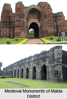
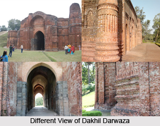
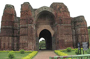
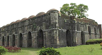
 Gaur: The remnants of 14th and 15th century Bengal, which are worth seeing, are the Bara Sona Mosque, Dakhil Darwajah (built in 1425), Qadam Rasul Mosque, Lattan Mosque and the ruins of the extensive fortification. There are colourful enamelled tiles on the Gomti Gate and Firoz Minar. Gaur is about 12 km south of Malda, right on the Indo-Bangladesh border.
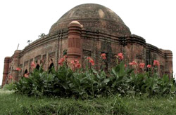
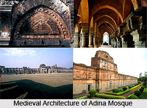
Pandua: Pandua situated on the main highway is 18 km north of Malda. Adina is another 2 km north of the village of Pandua, where Adina Mosque is one of the most famous places for the tourist. Sikander Shah built it in 1369 and the mosque shows the achievement of the then Muslim rulers. Eklakhi mausoleum (built at a princely cost of one lakh rupees) and several smaller mosques can be found nearby.
One can reach Malda by bus or by train. Bus services are available from Kolkata.
History of Malda District
 History of Malda District traces back, the whole tract of Malda is covering the extensive landscape including the areas of Tar, Diara and Barind. There is a mention of the Gourpura town in the account of Panini and the relics of the Gour kings in the region indicates the history of Malda is as old as the Gaur Kings in Bengal. The ancient history of Malda, recounts that the entire region of Malda (Gour and Pandua) was a part of the kingdom of Pundravardhana. These two cities -Gour and Pandua being the most prosperous cities used to be the capital of Bengal in the ancient and the medieval times. Finally these two cities with the agglomeration of the English Bazaar Town constitute the present district of Malda.
According to the ancient history of Malda, the core part of Malda, Gour had experienced several changes in its boundary and structure since 5th century until it was annexed with the Mauryan Empire. During the time of Mauryas, Pundravardhana survived as their provincial capital with Gour as the nerve centre. The ancient history of Malda as deciphered from the Brahmalipi seal and the ruins of the Mahastangarh in the Bogura district of Bangladesh reveals the fact that Gour and Pundravardhana were the major parts of the Maurya Empire and the principal sites to carry out trade in the Middle East and the South East Asia. The Chinese pilgrim, Hiuen Tsang`s accounts also throw lights to the ancient history of Malda.
The Guptas when overpowered the Mauryas, the entire region of North Bengal came under the sway of the Guptas. Consequently the kingdom of Pundravardhana became the part of the Gupta Empire. The Allahabad Pillar inscription of Samudragupta clearly indicates that the entire region of North Bengal as far as the east upto Kamrup was incorporated with the Gupta Empire. From the evidence narrated in the Allahabad inscription, Pundravardhana existed as the key site of trade even in the history of the Gupta era in Malda.
After the Guptas the beginning of the 7th century in Pundravardhana is marked with the rise of Sasanka in the history of Malda. Sasanka, the most potential King ever been in Bengal since its advent. Sasanka, originally the king of Kanvasuvarna, occupied the extended area of Gaur and retained his sovereignty for a span of long three decades. However Sasanka had to forfeit to the vigorous Pala Kings, who constitute the pages of Malda`s history from 8th century to the 11th century.
The Pala kings were the staunch Buddhist who propagated Buddhism in Bengal. Hence many Viharas grew up in the extended part of Barind paralleling the Nalanda, Vikramsila and Devikot. The ancient history of Malda therefore narrates the existence of the Buddhist cults and customs in Malda.
Once the violent Pala kings yielded before the Senas who ascended the throne of Bengal in the 11th century. The Senas were strictly Hindus and they patronized the propagation of the Hindu religion only. Unlike the Palas, the Senas did not encourage the propagation of the other religions. The ancient history of Malda narrates the significance and the customs of the Hindu religion flourished in Bengal during the Sena imperialism. During the reign of Lakshman Sena, the kingdom of Gaur was identified with the name of the king and was known as Lakshanabati.
The indigenous kings, till the end of the 12th century ruled the region of Bengal. But the incompetent successors of Sena could not retain the former glory of the Senas once they earned in Bengal. Finally, in 1204, the Muslim ruler, Bakhtiyar Khalji invaded and conquered Bengal.
As far as the ancient history of Malda is concerned, the Muslims were the sole domineer of entire Bengal till the British chief Lord Clive defeated Siraj-ud-daulah in 1757 in the battle of Plassey and initiated the British regime in Bengal as well as India. The modern history of Malda was inaugurated by the emergence of the British as the imperial head across India. When the British occupied India, with the control over the entire Bengal, the district of Malda was formed encompassing the comprehensive areas of Purnia, Dinajpur and the Rajshahi districts in 1813. At the time of Doctor BG. Hamilton, the present thanas of Gazole, Malda, Bamongola and some parts of the Habibpur district were included in the entire district of Dinajpur. In 1813, due to the increasing crimes in Kaliachak and Sahebgunj, separate deputy collector and a Joint Magistrate were appointed in English Bazaar area, due to its close proximity with these two disturbed areas. Thus these two regions and the other areas of Malda, integrated with the English Bazaar and present district of Malda came into existence. The history of Malda witnessed a change with the establishment of treasury in 1832 and survived as a full-fledged British administrative unit with the posting of a magistrate and collector.
The period of British history of Malda, points out, Malda served as the part of Rajshahi and Bhagalpur till 1905. During the partition of Bengal plan in 1905, Malda was decided to incorporate with the areas of East Bengal and Assam. But finally through a declaration of the Radcliff Award, in 17th August 1947 the district of Malda was attached with the areas of West Bengal. However the Nawabganj subdivision though served from the area of Malda, was given to East Pakistan as a subdivision of the Rajshahi district.
With the emergence of the Gaur kings in Malda, the history of Malda on looks the downfall and the uprising of various dynasties and civilizations till it was concluded by the British imperialism in India.
Geography of Malda District
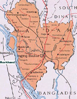
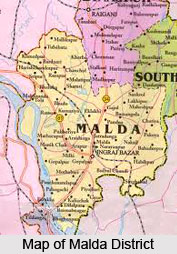 Malda district is located in the state of West Bengal, between the latitude and longitude figures of 24 degrees 40 minutes north to 25 degrees 32 minutes North and 88 degrees 28 minutes east to 87 degrees 45 minutes east respectively. It is surrounded by Bangladesh and South Dinajpur district in the east, Santal Parganas of Jharkand state in the west, North Dinajpur district in the north and Murshidabad in the south. The district consists of two sub divisions, Sadar and Chanchal. Englishbazaar is the headquarters station of the district as well as the Sadar subdivision.
The climate of the district is rather extreme- very hot and sultry during summer season, with a lot of rain and moisture in the air throughout the year. There are four main seasons in the year. Winter starts from about the middle of November and continues till the end of February. The period from March to May is the summer season. The rainy season starts in June with the coming of south - west monsoons and continues till the middle of September. October and the first half of November constitutes the post monsoons season. Average rainfall in the district is about 2453.1mm. The maximum precipitation occurs during the period from June to September.
The district consists mainly of low-lying plains, sloping towards the south with undulating areas on the northeast. The Mahananda River divides the district into two regions.
 The eastern region, consisting mainly of old alluvial and relatively unfertile soil, is commonly known as "rind" The western region is further subdivided by the river Kalindri into two areas, the northern area is known as `Tal` - it is low lying and vulnerable to inundation during rainy season, the southern area consists of very fertile land and is thickly populated, commonly known as `Diara`. The Ganga River flows along the south-western boundary of the district. Other important rivers are Kalindri, Tangoan , Punarbhaba, Pagla and Bhagirathi River.
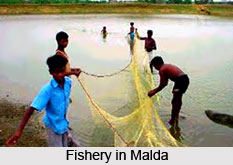
The flora of Malda district is merely a small portion of that extending form Kose to the Brahmapurtra. There is an alteration of the beels and village shrubberies with the drier jungle of the Barind region. Where the ground is not occupied by the usual crops, it is covered by abundant natural vegetation excepting the sandy beds of rivers. Old river beds, ponds, marshy land etc. have a copious vegetation of vallisneria and other plants. The areas which are subject to frequent inundation usually cover themselves with seedy grasses and in marshy parts with Rosainvolucrata. Some portions of Barind area are covered by jungles, which consist chiefly of thorny scrub bush jungles mixed with Pipal, Bat, Simul and Pakur trees and Nepal Bamboos. Species of thorny bamboos are also seen in Pandua areas near villages and embankment areas of Gour thickets or shrubberies, ordinary Neem tree, Jack-fruit tree, Tamarind, Bamboo, Peepul tree and Mango tree are seen in plenty. The soil of the western region of the district is particularly suited to the growth of mulberry and mango, for the production of both of which Malda has become famous. Though large games were found in plenty in the Malda district, the jungles have now mostly been cleared and their inhabitants exterminated by the Santals and Paharias, who have crossed the Ganges in large number to settle in Barind and other areas. The rivers, beels, and ponds of Malda produce considerable quantities of various categories of fishes such as Rohu, Katla, Chital, Boal, Magur, Shol, Hilisha, Pabda and varieties of Crabs, Prawns, Turtles etc. Pisciculture has been undertaken under various projects according to modern scientific methods.
Demography of Malda
The demographic report of Malda depicts that the percentage of male (51.59%) here is more than the female. The average density of population is about 800 per km sq. The rural folk constitute about 92.93% and only 7.07% of urbanized people constitute the total population of Malda, as per the demographic review of Malda.
The demographers in their reports about Malda say, that the principal language here is mainly Bengali and it is spoken by the 89.92% of population. The colloquial Bengali of Malda is not a conventional cosmopolitan one, rather it is a dialect, and has the influence of the language of Rajshahi in Bangladesh. According to the examination made by the demographers in Malda, Hindu and the Muslims are the prevalent religion here.
About 60 % of people are engaged in Cultivation. As the reports of the demography of Malda say, within 2001, about 1596 villages are facilitated with the supply of electricity. About 35.62% of populations of Malda are literate. The demography of Malda however reveals Malda as an underdeveloped district of West Bengal.
Culture in Malda
The culture of Malda represents the multi-ethnicity of the town Malda. During the partition a bulk of immigrants arrived from East Pakistan and resided in the extensive areas of Malda including the outskirts.
The culture in Malda is therefore a mixed culture. Dominated by the Hindu Bengali prevalently, the district of Malda is also inhabited by the people belonging to the Muslim and Santali sects. The folk culture of Gambhira is a characteristic feature of Malda. It signifies the everyday life blended with joy and sorrow, which is the very spirit of the common life in Malda. Various national and international matters are also presented in a unique way though that folk drama. The diversified culture of Malda represents the very spirit of the land of Malda.
Education in Malda District
 The economic fluctuations have a ghastly effect on the social as well as on the educational scenario of Malda. Presently Malda is one of the districts in West Bengal, which underscore a least educational development. However, Malda is the home to several popular schools of the state. Ramkrishna Mission Vivekananda Vidyamandir is considered to be the best school in the district. This school fetches a lot of students from the neighboring districts and also from the local areas.
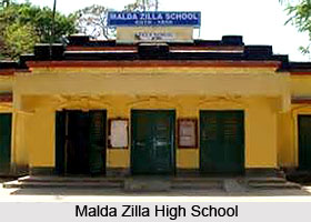
The medium of instructions in the schools here is Bengali, but the English medium schools like the St. Xavier`s, The Barlow Girls` High School, and A.C. Institution, Malda Zillah School (oldest in the Malda town and in the state as well) are some of the distinguished schools of Malda. Since the maximum of Malda is rural and the majority of population are the village folk, a bulk of people is afar the school system and only a few of the urban community come to schools, which is a hindrance for the all round educational development in Malda.
The education of Malda gets a boom with the physics department of the Malda College affiliated with the North Bengal University .The engineering college and the technical institutions mostly related to the computer professional training have induced the vocational education in Malda. However a long time proposal is in the table for the construction of a university and a medical college in the core of Malda to augment the educational prosperity in Malda.
Presently the Government has implemented several steps to bring majority under the school system so that educational development of Malda can be induced.
Economy of Malda
The economy of Malda is essentially agrarian. Since Malda does not have the extensive resource of minerals and other infrastructure, industry could not develop to supplement the economy of Malda. Therefore the entire economy of Malda is suffering from the low per capita income, which affects the standard of living of Malda to a large extent. Not only the per capita income, Malda presently encountered grave problems like, low yield per unit area, poor industrialization, shortage of capital and entrepreneurship and large labor surplus, which affected the economy of Malda.
Paddy, wheat, jute and other Rabi crops are the principal agricultural products. However the production of these food crops are included in the category of subsistence farming, which does not supplement the economy of Malda directly except providing the daily requirements of the local inhabitants.
The economy of Malda is significantly supported by the production of raw silk in Malda. Malda is the largest producer of raw silk in West Bengal and in the state`s economy Malda shares an important role. The annual estimated production of raw silk in Malda is 85% of total output of the state, which draw about 4 crores by exporting only the surplus. Apart from the production of raw silk, another important aspect of the economy of Malda is the production of mango. About 180 km2 of land is covered with the mango orchards, which produces about 3, 60,000 tones of fruits. The mangoes produce in Malda makes a business of 5.5 crores annually. Though the finest quality of mango produced in Malda is Gopalbag, nearly all the varieties namely Brindaboni, Ashsina, Langra, Kishanbhog and Fajli are produced, which also accounts for a large quantity of export. Hence the economy of Malda is solely dependent on the raw silk and the mangoes produced locally.
Because of the fluctuations in the growth rate and consequently the price rate of mangoes the economy of Malda cannot reach the estimated rate of income per year. Hence the continuous fluctuations have affected the economic scenario of Malda. The price of the mangoes produced in Malda varies according to the categories and the impact of weather on the crop for hail and heavy rains. A bumper crop actually comes once in four years and is followed by a bad year in which the production may come down to an average limit of 25% to 30%. The moderate crop with an average production of 45% to 50% follows it. Then comes another year of meager production. The cycle of bad and good years badly affected the production of mango, thereby affected the economy of Malda.
Monuments in Malda
 Monuments in Malda dates back to the rule of the Muslims and the British. Malda or Old Malda is situated at a distance of about four miles from the English Bazaar. It is a small town, located at the meeting point of the Kalindri and Mabananda rivers which once prospered as the port of Pandua. During the eighteenth century it thrived as a cotton and silk market, with Dutch, English and French factories, but due to the shifting of the English factory to English Bazaar in the year 1771, Malda lost its prosperity and it declined throughout the nineteenth century.
It is one of the eighteen districts of West Bengal which is located in close proximity to the confluence of the River Kalindri and Mahananda River. A number of prominent silk industries of Bengal are established in the district of Malda. The district is also one of the major rice, jute and wheat distribution centers. In the eighteenth century, Malda used to be one of the most prosperous centers for industries in the state of West Bengal. The place was renowned for cotton and silk. Among the notable historical monuments, the Nimasari Tower and Jami Masjid are situated in Malda. Pandua, located at a distance of about eighteen kilometers to the north of Malda, is one of the notable archaeological sites having some of the famous Muslim architecture like the massive Adina Mosque, constructed by Sikander Shah in the year 1369. Constructed over a Hindu temple, the mosque is considered to be India`s largest mosque having three hundred and seventy eight small domes. Another major historical attraction is the Eklakhi mausoleum and a number of smaller mosques scattered in Pandua.
At a distance of twelve kilometers to the south of Malda is Gaur. Situated on the India and Bangladesh border, Gaur is a renowned historical place which belonging to the 14th and the 15th century. Some of the relics available there include the Dakhil Darwajah, the Bara Sona Mosque, Qadam Rasul Mosque, Lattan Mosque and the remains of the broad fortification. One can also see the colourful enameled tiles on the Firoz Minar and Gomti Gate. A museum is also there in the district of Malda which houses the important archaeological findings at Pandua and Gaur.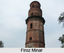
The old English factory at the Malda district, erected in the year 1656, has virtually disappeared, the site being marked by the Court House and public buildings. A column erected in the year 1771 by Thomas Henchman stands in the courthouse compound. Most of the houses were constructed with masonry taken from the nearby ruins of Pandua and Gaur. The prominent buildings include the Jami Masjid, constructed by carved brick and stone by Musum Saudagar in the year 1596. It has a barrel-vaulted corridor based on Bengali and north Indian forms. The central bay of the facade sweeps high above the flanking bays and the pillars at the entrance are handsomely carved.
The Shrine of Shah Gada is famous for containing the remains of a parrot which learned to recite prayers from the Holy Quran. The Phuti Masjid is now entirely ruined and overgrown by jungle. The Nawab`s Mosque is attributed to the munificence of the Nawab of Murshidabad. Across the river is the Nim Serai Minar, a curious tower which is 55 ft tall and 18 ft in diameter. It is studded with projecting stones resembling the tusks of an elephant and was probably a watch tower or hunting-tower, used to display the heads of thieves. The top can be reached via a winding staircase. It is comparable to the Hiran Mahal at Fatehpur Sikri. Inside the town is the Katra, originally a warehouse and later a fortified sarai or inn for travellers. Today, only the traces of the arched gateways remain.
Tourism of Malda
 The immense traditional legacy, that Malda inherited from its glorified past history helps the flourishing growth of the tourism in Malda. Malda, being a seat of the indigenous and the alien communities the tourism industry has been able to endow Malda with rich heritage. The tourism industry in Malda grows up centering the conventional bequest on Malda. The relics of the ancient buildings, the historical sites constitute the important places of tourist interest in Malda.
The Gaur and Pandua region is the heart of the tourism industry developed in Malda. Gaur is an important name in the history of Malda, since the primeval of history of Malda. The tourism in Gaur has developed round the mosques built during the Muslim regime in Malda. The relics of particular worth visiting are the Bara sona Mosque, Dakhil Darwaja, Qadam Rasul Mosque, Lattan Mosque and the ruins of the extensive fortification. The interesting thing about these mosques is that the artistic fabrication on the walls of the mosques is the representation of the Muslim`s traditional art.
 The colorful enameled tiles on the Gomti gate and the Firoz Minar utters the sophisticated taste of the contemporary people. Pandua is another arm of the tourism in Malda. Pandua is of enormous archaeological importance and the impressive Muslim architecture. The Adina Masjid is famous for being the largest mosque built in India. The remarkable feature of the Adina mosque is that it is built over a Hindu temple having 378 small domes. The structure of the Adina Masjid represents the equal importance of the Hindus and Muslim in Malda. The Eklakhi mausoleum and the other smaller mosque are also the important tourist centers in Malda. The tourism in Malda offers a lot of interests to those have a taste for the ancient culture and tradition.


