


 Changlang District has been showered with the bounties of nature. It is the eastern most part of India. The district is bounded with Myanmar (Burma). The morning Sun light first touches the Horizon of the eastern Mountain ranges of the district while the rest of the country is still napping in their cozy beds waiting for the emergence of the dawn of the day.
The Changlang district has four Sub-Divisions. The Deputy Commissioner is the overall in-charge of the district and maintains law and order with the help of administrative officers and police forces. Moreover, the villagers have their own customary administrative systems in the form of traditional village councils consisting of the Gaon Buras and members. Some of the tribes in Changlang like the Tangsas and Singphos have democratic form of social life. They do not have a kinship system and the village Panchayats settles all their disputes. Changlang District has been showered with the bounties of nature. It is the eastern most part of India. The district is bounded with Myanmar (Burma). The morning Sun light first touches the Horizon of the eastern Mountain ranges of the district while the rest of the country is still napping in their cozy beds waiting for the emergence of the dawn of the day.
The Changlang district has four Sub-Divisions. The Deputy Commissioner is the overall in-charge of the district and maintains law and order with the help of administrative officers and police forces. Moreover, the villagers have their own customary administrative systems in the form of traditional village councils consisting of the Gaon Buras and members. Some of the tribes in Changlang like the Tangsas and Singphos have democratic form of social life. They do not have a kinship system and the village Panchayats settles all their disputes.
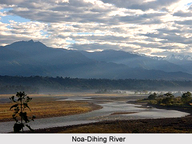
Geography of Changlang District The district is located between 26 degrees, 40 minutes north, and 27 degrees and 40 minutes north latitude. The longitudinal expanse of the district is between 95 degrees and 11 minutes to 97 degrees and 10 minutes east. The district is bounded by Lohit District in the north, Myanmar in the east and south, Assam lies to the west of Changlang District and Tirap District lies to the south-western part of it. Changlang District has an area of 4662 square kilometres. Some of the famous Rivers of Changlang District are Noa-Dehing, Namchik and Tirap. Other Rivers are Namphuk, Dapha, Namphai, Tissu, Tarit, Tara, Tikeng, and Tiging. Most of the rivers after winding through the hills and valleys come down to the plains and join Buri-Dihing River. The Noa-Dihing River originates from Patkai Hills Or Purvanchal Ranges, flows east to west through the entire north-eastern and northern stretch of the District. The Tirap rises from a high peak between Laju and Wakka, flows southwest to Northeast passing through the Changlang town, and ultimately meet Buri-Dihing near Lekhapani in Assam. These rivers become turbulent during the monsoon and harm the agricultural fields to a large extent but at the same time increases the fertility of the soil by depositing silt along their courses. The climate is moderate and pleasant. December to February months experiences a cold wave. January is the coldest month when the average maximum and minimum temperature is about 22.0 degree Celsius and 13.0 degree Celsius respectively. The rainfall of the region is also influenced by the varying heights of the district largely. The annual rainfall ranges from 3800 mm to 4866 mm. The major rainfall is received during June to October. Demography of Changlang District According to the Population Census in the year 2011, the Changlang district has a population of 147,951 people. This gives it a ranking of 598th in India out of a total of 640 districts in India. The district has a population density of 32 inhabitants per square kilometre. Changlang District has a sex ratio of 914 females for every 1000 males. The literacy rate of this district is 61.9%. Changlang is populated by tribal groups, namely Tutsa Tribe, Tangsa Tribes, Nocte Tribe, Chakma Tribes, Singpho Tribe and the Lisu Tribe. The Tibetan refugees are clustered at Choephelling Tibetan Refugee settlement in Miao region. This population settlement was set up in 1976 with a hosts a population of 2200. The Tangsa tribe is comprise of a number of Sub-Tribes, namely Muklom, Havi, Longchang, Mossang, Jugli, Kimsing, Ronrang, Mungrey, Longphi, Longri, Ponthai, Sangwal, Tikhak, Yungkuk, Sakieng and Thamphang. They occupy the southeastern hills of the district along Indo-Myanmar border and Namchik basin. The Singphos occupy the plain foothills area of northern part of the district under Miao, Bordumsa and Diyun circles. The Tutsas live in the western part of the district under Changlang and Khimiyong circles. Other tribes who have migrated to the district are Noctes (APST), Lisus (Yobin), and Deoris. The Tibetans, Chakmas and Hajongs came as refugees. Tourism of Changlang District Changlang District is known for its sprawling lush greenery overhauling beautiful hills and rivulets. There are some places, which are situated in beautiful locations. These places are very attractive for seasonal visitors. Some of the popular tourist destinations of Changlang District are Miao, Namdapha Tiger Reserve and Namdapha National Park, World War II Cemetery, Nampong, Pangsau Pass and a lot more. Finally it can be concluded saying that Changlang District of Arunachal Pradesh is basically a beautiful district inhabited by the simple tribal population who have till today have kept intact the treasure of Mother Nature. |
| |||


Home > Travel > States of India > Arunachal Pradesh > Districts of Arunachal Pradesh > Changlang District
Changlang District
| Changlang District in Arunachal Pradesh is a beautiful district that lies in the eastern part of the north-east Indian state and attracts a large number of tourists. |
| ||||||||||||||||||||||||||||

