


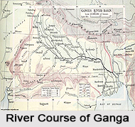
 Course of River Ganges can be classified into three parts: Upper Course, Middle Course and Lower Course. Ganges originates in the Himalayan Mountain Range at the confluence of six rivers. The Alaknanda River meets the Dhauliganga at Vishnuprayag, the Pindar at Karnaprayag, the Nandakini at Nandprayag, the Mandakini at Rudraprayag and finally the Bhagirathi River at Devprayag. Since these confluences, the river flowing is known as the River Ganga. Course of River Ganges can be classified into three parts: Upper Course, Middle Course and Lower Course. Ganges originates in the Himalayan Mountain Range at the confluence of six rivers. The Alaknanda River meets the Dhauliganga at Vishnuprayag, the Pindar at Karnaprayag, the Nandakini at Nandprayag, the Mandakini at Rudraprayag and finally the Bhagirathi River at Devprayag. Since these confluences, the river flowing is known as the River Ganga.
Upper Course of Ganga River The Bhagirathi River is considered the source stream and the stream originates at the Gangotri Glacier, at a height of 7,756 m or 25,446 ft. The melting snow and ice from glaciers including glaciers from peaks such as Nanda Devi and Kamet Peak feed these rivers. After travelling 200 km through the Himalayas, the Ganges emerges at the pilgrimage town of Haridwar in the Shivalik Hills. At Haridwar, a dam diverts some of its waters into the Ganges Canal, which links the Ganges with its main tributary, the Yamuna. The Ganges, whose course has been roughly south-western until this point, now begins to flow southeast through the plains of northern India. Middle Course of Ganga The river Ganga follows an 800 km curving course passing through the city of Kanpur before being merged by the Yamuna River at Allahabad from the southwest direction. This point is known as the Sangam at Allahabad. Tribeni Sangam, is considered as a sacred place in Hinduism. According to ancient Hindu texts, at one time a third river - the Sarasvati met the other two rivers at this place. 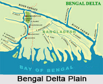 Lower Course of Ganga River Lower Course of Ganga River
Numerous tributaries and distributaries such as the Kosi River, Gandak River, Son River and Ghaghra River join the Ganga River and form an alarming current in the stretch between Allahabad and Malda District in West Bengal. On its way it passes the towns of Mirzapur, Patna, Varanasi, and Bhagalpur. At Bhagalpur, the river moves across the Rajmahal Hills, and begins to run southwards. At Pakur, the river begins its erosion with the moving away of its first distributaries, the Bhgirathi-Hooghly, which goes on to form the Hooghly River. Near the border with Bangladesh the Farakka Barage was built in 1974. This barrage controls the flow of the Ganges, diverting some of the water into a feeder canal linking the Hooghly to keep it comparatively free of silt. Division of Ganga River and Padma River After entering Bangladesh, the main branch of the Ganges is known as the Padma River until the Jamuna River joins the largest distributaries of the Brahmaputra River. Even more downstream, the Meghna River feeds the Ganges. The Meghna River is the second largest tributary of the Brahmaputra, and takes on the Meghna's name as it enters the Meghna Estuary. Fanning out into the 350 km wide Ganges Delta, it finally empties into the Bay of Bengal. The Amazon and the Congo are the only two rivers that have greater discharge than the combined flow of the Ganges, the Brahmaputra River and the Surma-Meghna river system. |
| |||


Home > Reference > Geography of India > Natural Resources of India > Water Resources in India > Indian Rivers > Himalayan Rivers > Ganga River > Course of River Ganges
Course of River Ganges
| Course of River Ganges starts from its origin at Gangotri, the mouth of Gomukh and finally ends at the Bay of Bengal in West Bengal and Bangladesh areas. |
| ||||||||||||||||||||||||||||

