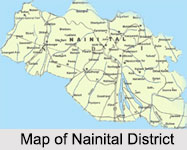
 Nainital District is one of the administrative districts of Uttarakhand. Nainital is the district headquarters. It is also the headquarter of Kumaon division of Uttarakhand.
Nainital District
Nainital District of Uttarakhand lies in the Kumaon division of Himalayan Mountain Range. Nainital Lake is a popular destination in Nainital District.
Introduction
Nainital District is one of the administrative districts of Uttarakhand. Nainital is the district headquarters. It is also the headquarter of Kumaon division of Uttarakhand.History of Nainital District
 History of Nainital district, Uttarakhand, can be traced back to the period of British settlements in India. In the year 1815 Kumaon and Garhwal regions were occupied by the British rulers. On 8th May 1815, E. Gardiner was appointed as Kumaon division`s commissioner. The second commissioner of Kumaon division, Mr. G.W. Traill, arrived in 1817 and carried out the second revenue settlement of Kumaon. He was the first European who visited Nainital but his visit was not much popularized owing to the religious sanctity of the place.
Mythological History of Nainital District
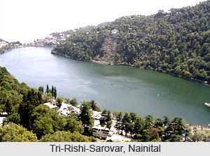
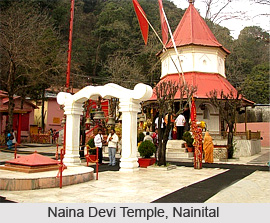
Indian mythology states that the Tri-Rishi-Sarovar (lake of the three sages) in Nainital was formed by the sages Pulaha, Pulastya and Atri who reached the place on a penitential pilgrimage. For quenching their thirst, the sages dug a hole there and drew water from the sacred Mansarovar lake of Tibet and filled it. For this, Nainital is also called as `Manas Khand` of the `Skanda Purana`. Apart from this, the place is amongst the 64 sites where parts of charred body of Sati fell when her corpse was carried around by Lord Shiva in grief. It is believed that the left eye (Naina) of Sati fell at this place from which the patron deity of the town emerged. Myths also say that the lake of Nainital resembles an emerald eye. The temple of Naina Devi stands at the northern end of the lake. This gave the town its name, Nainital, derived from `Naina` and `tal`, which means lake.
Modern History of Nainital District
In 1839 an English businessman known as P. Barron reached the place with his friend who was an avid hunter. They arrived at the hills of Nainital for hunting and got lost along their journey. While tracing their way back they eventually discovered a placid lake. The enchanting lake and the magnificent natural beauty of the place pleased Barron so much that he built a European Colony along the bank of the lake and left behind his sugar business. Afterwards, in an issue of `Englishman Calcutta` published about Nanaital and the discovery of the lake near Almora.
According to historical records, by 1847, Naitinal emerged as a popular hill resort attracting tourists from distant places. 3rd October 1850 marks the day of the formation of Nainital Municipal Board which became the second Municipal Board of North Western Provinces. To promote the formation of a town in the place, the administration of the land was transferred to the rich Sah community of Almora. The transfer was done on the condition of building houses on the land. Naitinal was made the summer seat of the North Western Provinces in the year 1862. This summer capital then started expanding remarkably with the construction of spectacular bungalows throughout the town along with other developments such as rest houses, marketing areas, clubs, recreation centres and many more. Several other administrative units and the secretariat were also formed. Naitinal also emerged as an educational hub much preferred by the British people.
Geography of Nainital District
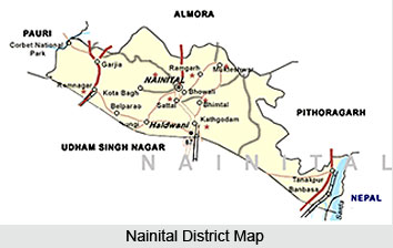 Geography of Nainital district encompasses both towering mountains as well as plains. Nainital district, in the state of Uttarakhand, is situated at the Kumaon division of the state. Almora district lies towards its north whereas Udham Singh Nagar district is located on its south. Eastern part of the district is bordered by Champawat district and on its western border lays Pauri Garhwal district. Himalayan ranges lies on the northern side and the southern side of the district is flanked by plains. This combination makes the climate quite pleasant.
Nainital district spans over a geographical area of 4251 square kilometres. Two geographical zones divide the district namely Hilly and Bhabar. The outer Himalayan region is termed as the Hilly region. Geologists call it Krol. Baudhansthali forms the highest peak of the district, rising to an altitude of 2623 metres above sea level. It is located near Binayak, adjacent to the town of Nainital. Hilly region of Nainital district houses numerous lakes of big and small sizes. Some of the large lakes of the district are Lokhamtal, Harishtal, Malwatal, Nainital, Khurpatal, Naukuchiatal, Sat Tal and Bhimtal. Bhabar region refers to the foothill area of the district. This region takes its name from a type of tall growing grass which is found in this region. Bhabar region is known for deep levels of underground water.
The main river of the district is Kosi which originates from Koshimool near Kausani. The river flows on the western part of the district. Several rivulets also flow in Nainital district like Baur, Dabka, Bhakra, Gaula etc. Dams have been built on most of these rivulets for irrigation purposes. Rainfall is abundant in Nainital district.
Climate of Nainital District
Nainital District enjoys the climate of tropical, subtropical, temperate, sub alpine and alpine type. The Terai and Bhabhar belt has a moderate climate resembling with plain areas. The middle Himalayan ranges are temperate zones. Alpine zone refers to the land between the snow line and above 2000 metres and is a typical high Himalayan belt. The soil structure and texture also varies from high sandy soils having 70 percent to 80 percent sand to clay soils in which the clay percentage is up to 20 percent. In between vast tracts possess sandy loamy soils which are neither heavy nor very light.
Natural Vegetation of Nainital District
The hilly region of Nainital District is covered with Himalayan subtropical pine forests. The major trees are Oak, Buruns, Kaphal and other trees. There are small tracts of cultivated lands and fruit orchards in between the forests in this region.
Demography of Nainital District
According to the Population Census in the year 2011, Nainital District has the population of 955,128. The population density is about 225 inhabitants per square kilometers. The literacy rate of Nainital District is about 84.85 percent.
Education in Nainital District
There is a proper government educational setup in Nainital District besides having several prestigious public schools. As per survey records, there are around 1260 Junior Basic Schools, 356 Senior Basic Schools, 198 Secondary Schools, 4 degree colleges and Kumaon University. Nearly 90 percent of Junior Basic Schools are located in the rural areas while almost 85 percent and 65 percent respectively of Senior Basic and Secondary schools are located in urban areas. For technical education Nainital Polytechnic provides 3 year diploma courses in various streams like Civil, Mechanical, Electronics, Electrical and 2 year diploma courses in Pharmacy, Computer Applications, and short hand - secretarial work. Various private institutions affiliated to Kumaon University are also providing MCA, B. Ed and MBA courses.
Culture of Nainital District
 Culture of Nainital district in Uttarakhand is quite diverse and vibrant which emerged due to the confluence of various traditions, rituals and lifestyles. However, some of the features form the unique identity of the district and can be witnessed quite dominantly throughout the region. Although, owing to modernization, many new practices have formed a part of the district culture, there are many ancient and native traditions which still adheres people belonging to different ethnicities. Some of the traditions and practices have evolved as per the environment and availability while many have prevailed here since ancient times. Different religious beliefs, cuisines, fairs and festivals and lifestyles can be observed here which greatly enriches the cultural diversity of the nation as well.
Society in Nainital District
In the main towns of the district, cosmopolitan culture is prevalent. An assemblage of traditions and customs of different origins can be witnessed here owing to the presence of diverse people through generations. Majority of the population in the district follow Hinduism whereas the rest are the followers of Sikhism, Islam, Christianity, Buddhism and other religions. Kumouni traditions are predominant in the district.
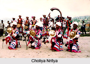
 Tallying of horoscopes is an essentiality of marriages. Marriages in the district are quite colourful and include rituals as Suwal Pathai, Ganesh Pooja, Dhuliargh, Kanya-daan, Phere, Vidai. In kumouni tradition a vibrant form of dance known as Choliya Nritya is performed along with the playing of trumpets, dhol etc.
Cuisines in Nainital District
The main grain consumed in the district is rice; however, maduwa, wheat and other grains are also common. The preferred pulses in the region are Masur, Bhatt, Gahat and Urad. Special food delicacies are prepared during ceremonies such as Khatai, Raita, Kapa made of Palak, Bada, Pua, Poori, Singhal and Kheer. Typical Kumouni foods cherished by the people of this region are Gaba vegetable, Jholee made from mattha, Gautras made of Gahat, soya been etc.
Fairs and Festivals of Nainital District
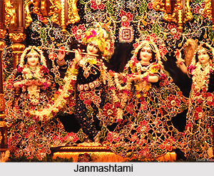
A number of fairs and festivals are celebrated in the district which catalyses the cultural intermingling, promoting cultural diversity and social associations. Common festivals observed in the district are Sankranti, Vasant Panchami, Shivaratri, Holi, Ramnavami, Raksha Bandhan, Janmashtami, Diwali etc. Grand fairs are also organized in different regions which also help in augmenting the district economy. Fairs of the district include Uttaraini Mela, Harela Mela, Somnath fair and many more.
Life Style of Nainital District
Nainital district houses a number of temples and monuments which exhibit magnificent architecture and artistic embellishments.
 The sculptures of these monuments vary according to the eras when these were constructed. The mode of worship also differs from region to region. Some of the common local deities are Gangnath, Aidi, Sam and Bholanath. Different religious as well as social activities can be witnessed here. Superstitions are also quite prevalent in the district. During auspicious occasions, `tilak` is put on the forehead which is prepared by processed turmeric. Mourning calls are usually made on Tuesday and Saturdays whereas courtesy calls can be made on any day except Tuesday and Saturday. Vermilion is put by the married women on their forehead during special occasions and golden nose ring termed as `Nath` is worn. Traditional dress for women is `ghaghara-pichora` which is usually worn during ceremonial days. Sari is the common attire of women.
Traditions of Nainital District
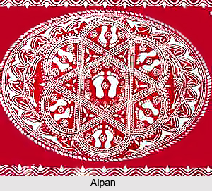
cludes colourful ornamentation on Aanchal cloths. `Pichora` is the ceremonial women wear which is made of muslin cloth dyed in yellow colour. Exquisite designs are printed on it with red colour which includes motifs of Swastika, moon, sun, conch and bells. During ceremonies, the walls and floors of the houses are decorated with beautiful designs which are drawn by rice paste mixed with ochre. Specific `tantric motifs` called Yantra and Peeth are used to adorn the seat of deities. During Namkaran Sanskar wooden chauki is adorned with the Aipan which consists of motifs of bell, sun, moon etc. Aipan in thread ceremonies comprise the zodiacal sign of `great bear` arranged in hexagons which is believed to invoke the blessings of Sapta-Rishis. In marriage ceremonies, design of big water-jar is drawn on the Dhuliargh Chauki which is symbolic of the primordial water which gave rise to the universe.
Administration of Nainital District
Administration of Nainital District is under the control of District Magistrate. The main activities of district administration include maintenance of Law and order, revenue administration, monitoring of development works and control over other government departments. For the administrative work District Magistrate is supported by a team of officers. Like for instance, for law and order by Senior Superintendent of Police (SSP), for development works by Chief Development Officer (CDO) for revenue administration Additional District Magistrates and Sub-Divisional Magistrates, and for forest related work by District Forest Officers. The other activities of District Magistrate`s office include issuing and cancellation of arms licenses, keeping land records, registry work, and redressal of court cases related to lands. The common people put their grievances before the Collector and these are generally related to and taken care of by different departments. One section of the District Collector`s office looks after these public complaints and traces their answers from the concerned departments.
For administrative purpose, Nainital District is divided into five sub-divisions (Pargana) and eight Tehsils. Each subdivision is headed by a Sub Divisional Magistrate (Deputy Collector) and Tehsil by a Tehsildar. The sub-divisions of Nainital District are Nainital, Haldwani, Ramnagar, Dhari and Kosiyakutoli. Tehsils are Nainital, Haldwani, Ramnagar, Kaladhungi, Lalkuwa, Dhari, Kosiyakutoli and Betalghat. The administrative history of Nainital goes back to 1815 A.D. as per historical records.
Senior Superintendent of Police (SSP) is the head of Police department in Nainital District. There are further breakups under different officers which include the City Superintendent of Police, Deputy Superintendent of Police, Circle Officers and Sub Inspectors under the SSP for the control of law and order in the district. Administration of Nainital District includes around thirteen Police Stations. In the hilly areas law and order work is looked after by revenue Patwaris. There are 2 fire service stations in the district one each at Nainital and Haldwani.
The revenue collection work is done by Tehsildars with the help of Naib Tehsildars, Amins and other Tehsil staffs. The other main work of Tehsils is to keep record of Land. Land record work is maintained by Patwaris at each Tehsil. Each Patwari is responsible for land records of his own circle having generally eight to ten revenue villages. There are 1093 revenue villages in Nainital District. A major portion of Nainital is covered with forests and for the management of this vast resource there is a setup of forest departments consisting of Conservator, District Forest Officers, Rangers, etc. For conserving forest based resources Van Panchayats have been organised in the district. There are around 400 Van Panchayats in Nainital District. Beside these departments, administration of Nainital District also includes several other departments such as Public Works Departments and Rural Engineering Service (RES) for government construction work and Social Welfare Department.
Fairs of Nainital District
 Fairs of Nainital district represents the vibrant culture of the place that have accumulated in the lives of people dwelling in the district. Diverse traditions, rituals and customs in the district have led to the evolution of different fairs and festivals in the district. People belonging to different cultural backgrounds and ethnicities participate in these events with equal vigour and add to the gaiety and spirit of the festivals. Grand fairs organized during different festivals also contribute in the economy of the district through trading of different artefacts. Fairs of Nainital district also allure tourists from distant regions to explore the cultural ethos of the place.
After harvesting season people of Nainital District mostly engage in amusement. And thus a festival is generated and with that the fairs are organised. At the transition of sun from one constellation to another Sankranti is observed. Each Sankranti has a fair or festival connected with Kumoun. Fooldeyi, Bikhauti, Harela, Ghee Sankranti, Khatarua, Uttaraini are the mostly observed Sankranti throughout the region. Fairs are organised on these occasions on certain places.
 Chhota Kailash Fair
Chhota Kailash fair is an annual fair organized during the occasion of Shivaratri in the month of February. This religious fair showcases the vibrant culture and tradition of this region. During Shivaratri a number of people visit Chhota Kailash.
Hariyali Devi Fair
Hariyali Devi Fair is another grand fair held during the occasion of Harela in the district, in the month of July. The celebration marks the new season of corp.
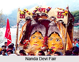
Nanda Devi Fair
Nanda Devi fair is organized in the district every year in the month of September. Various cultural programs are also organized during the fair by different non government organizations and the local government. Numerous students of local schools and colleges participate in the cultural programs of the fair.
Sharadotsav Fair
Sharadotsav Fair, also known as winter fair, is held in Nainital during the month of October. Cultural programs organized in the fair include various folk dances and folk arts. The fair attracts a plethora of tourists from across the world, who visits the place to experience the wondrous culture and traditions of the district.
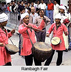
Ranibagh Fair
Ranibagh Fair is organized at Ranibagh which is located at about 30 kilometres from Nainital on the occasion of Uttarayani every year. The fair is religiously quite significant.
Tourist Places in Nainital
 Tourist places in Nainital are innumerable and they play a significant role in Nainital`s economy. This picturesque hill station is located in the Uttarakhand state of India. The different tourist places that attract visitors from various corner of the world are as follows:
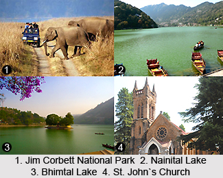
Nainital Lake: Nainital Lake also called Naini Lake is situated in the heart of the city. Nainital got its name from this lake. It is an eye-shaped lake. The northern end of the lake is known as Mallital, while the southern one is called Tallital.
Naina Devi Temple- Naina Devi Temple is located on the northern shore of Naini lake and was reconstructed after being destroyed in the 1880 landslide. Nainital is believed to be one of the 64 Shaktipeeths, where one of the body parts of Goddess Sati fell, when Lord Shiva had carried her body. The eyes of the Goddess are assumed to have fallen in Nainital.
Naina Peak: Naina Peak provides the most breathtaking view of the hill station of Nainital. It is situated at a distance of about 6 km from the main town. It is the highest peak of the hill station. It is also known as the China Peak or Naini Peak.
Governor`s House: It was built in the year 1899 and designed in the Victorian Gothic domestic style by the architect F.W. Stevens. Presently, it is serving as the official guest house for the governor of Uttarakhand and for visiting state guests.
Dorothy`s Seat: Dorothy`s Seat is located on Ayarpatta hill. It provides a beautiful view of the neighbouring country side. It is also known as Tiffin Top.
Pt. G.B. Pant High Altitude Zoo: This zoo is one of the two high altitude zoos in India. It comprises of various high altitude endangered mammals like Siberian tiger, snow leopard, goat antelope-ghooral and serao etc.
Snow View Point: Snow View Point is located at an altitude of 2,270 m. It is one of the coldest regions in Nainital. From here one can enjoy spectacular views of the snowbound high Himalaya, including Nanda Devi, Trisul, and Nanda Kot.
Gurney House: Gurney House is located on Ayarpatta Hill. It is the former residence of Jim Corbett. Currently, it is serving as a private residence and is open to visitors as a museum of Corbett memorabilia.
Jim Corbett National Park: Jim Corbett National Park is the oldest national park in India. It contains 488 different species of plants and variety of animals. It is India`s first national park which comprises hills, Riverine belts, marshy depressions, grass lands and large lake. Dense moist deciduous forest consists of sal, haldu, pipal, rohini and mango trees.
St. John`s Church: St. John`s Church was built in 1844. The church is located on Mallital, the north end of the town. The Bishop of Calcutta, Daniel Wilson laid the foundation of the church in Nainital.
Eco Cave Gardens: Eco Cave Gardens comprise of six caves along with a musical fountain. This natural garden is situated just next to Kumaon University Campus.
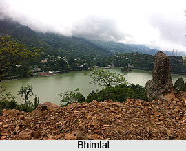
Bhimtal Lake: Bhimtal Lake is situated 22 km from the city centre and is the biggest lake of Nainital. It is named after one of the Pandava brothers Bhima. It has an island within its precincts.
Nakuchia Lake: Nakuchia Lake is known for having nine corners. It is located 26 km from Nainital and 4 km from Bhimtal. Nakuchia Lake has managed to maintain its serenity till date.
Khurpa Tal: Khurpa Tal is surrounded by terraced fields, from which it presumably gets its name. This lake is situated about 10 km by road from Nainital at an altitude of 1,635 m.
Connectivity of Nainital
Nainital can be accessed by air, rail and road. The two closest airports are located at Pantnagar and New Delhi. The nearest railway station is situated at Kathgodham, at the foothills of the Kumaon hills. Travelling by road is also convenient. Travellers can avail bus service from New Delhi to Nainital, which include air-conditioned, non-air-conditioned, sleeper and Volvo buses.
Excursion Points in Nainital
 Excursion points in Nainital, Uttarakhand, offer a wondrous and diverse experience to the visitors. The places are adorned with picturesque natural beauty and enchanting landscapes. Some of the most gorgeous lakes of the country can be witnessed here. These sites also offer spellbinding views of Himalayan ranges along with captivating sunrise. A number of pilgrimages also form the major tourist attractions of these places and allures devotees from distant regions of the country. Apart from savouring the grandeur of nature, excursion points in Nainital also offer an amazing experience of recreational activities like trekking, angling, fishing and boating.
Baijnath
Baijnath is located at an altitude of 1125 metres on a flat valley along the banks of Gomti River. Here the temple complex of Baijnath was established by the Katyuri kings. Temples of Brahma, Surya, Kuber, Chandika, Parvati, Ganesh and Shiva are also situated in Baijnath.
 Bhimtal
Bhimtal lies at a distance of 22 kilometres from Nainital at an altitude of 1370 metres. The place is famous for a vast and beautiful lake where tourists enjoy a pleasant boating experience. Amidst the lake, an island is located which houses a restaurant for the visitors. The place also houses a dam over which an ancient temple complex of Bhimeshwar, belonging to 17th century, is located.
Bhowali
Bhowali is situated at about 11 kilometres from Nainital town, at an altitude of 1706 meters. Basically it is a road junction which serves all the hill stations situated near Nainital. The place has mesmerizing scenic beauty and is also famed as a fruit mart. Bhowali is also known for T.B. sanatorium which was founded in 1912.
Binsar
Binsar is one of the most spectacular places in Kumaon Himalaya, known for its captivating scenic beauty. Ferns, alpine forests, wild blooms and hanging moss adorn this exquisite place which offers a splendid view of the Himalayas. Trekking is also done in this region amidst rhododendrons and Himalayan oaks.
Ghorakhal
Ghorakhal is situated near Bhowali. The place is popular for the temple of Lord Golu, the local deity of the hill people, and the Sainik School.
 Kainchi Dham
Kainchi Dham is a famous pilgrimage site located near Nainital. The Ashram of renowned Neem Karoli Maharaj has rendered recognition to the place.
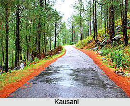
Kausani
Kausani lies in a spectacular landscape; situated over a narrow ridge and embraced by dense pine forests. Low mountains separate Kausani from the Nanda Devi range of Himalayas. The place offers a breathtaking view of towering Himalayas, especially the snow capped Nanda Devi and Trishul ranges. Enthralling sunrise can also be witnessed from Kausani. In the year 1929 Mahatma Gandhi had spent 12 days at Kausani and the guest house where he stayed is known as Anashakti Ashram. It is also the birth place of famous poet Sumitranandan Pant.
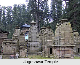
Jageshwar
Jageshwar is enlisted among the 12 Jyotirlings of the country. Ancient monarch-sized deodars border the narrow valley where Jageshwar is situated. Numerous shrines dot the place among which three are quite popular owing to their magnificent sculptures. These three shrines are dedicated to Pushtidevi, Mrityunjaya and Jageshwar. The temple of Jageshwar has artistic sculptures of `dwarpals` at the entrance. The artistic carvings on the temple show profound Buddhist influence.
Mukteshwar
Mukteshwar is another beautiful excursion site at a distance of 51 kilometres from Nainital. The place was nurtured by the British people in 1893 as a research and education institute. Dense coniferous forest and fruit orchards embrace the place bestowing a captivating look to Mukteshwar. It also offers a magnificent view of the long Himalayan ranges and an ancient Shiva temple.
Naukuchia Tal
Naukuchia Tal, located 26 kilometres away from Nainital, is a deep and clear lake having nine corners. The lake, lying on a picturesque valley, offers a breathtaking view to the visitors. Angling and bird watching are some popular activities cherished here. Apart from this, yachting, paddling and rowing are also widely practiced here.
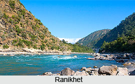 Ranikhet
Ranikhet, situated near Nainital, is a hill station endowed with splendid scenic beauty. Local myths say that the queen of Raja Sudhardev, Rani Padmini was highly impressed with the place and thus chose it as her abode. The place got the name Ranikhet since then which means `Queen`s Field`. The place offers an amazing experience to its visitors with it fragrant and invigorating mountain breeze, colourful chirruping birds, scenic landscapes and the spellbinding view of majestic Himalayan ranges. It is also the headquarters of Kumaon Regimental Centre (KRC) and hosts KRC museum and memorial. Other tourist attraction of Ranikhet include Upat Kalika with its best golf links, Chaubatiya Garden with its beautiful fruit gardens and a Government Fruit Research Centre, Bhalu Dam which is famed for fishing and Hairakhan Dham which hosts the ashram of Hairakhan Baba.
Sat Tal
Sat Tal is an enchanting place located at about 23 kilometres from Nainital, at a height of 1370 metres. The place is greatly cherished by nature lovers where an oak forest surrounds a group of lakes. The first lake while proceeding towards Sat Tal is Nal Damyanti Lake. It also hosts an Ashram of an American Missionary, Stanley Johns. Next lake on the way is Panna or Garude Lake. Proceeding further, a cluster of three lakes are found known as Ram, Laxman and Sita lakes.
Recently updated articles in States of India

History of Thissur District
Early History of Thissur District explains flourishing of the port cities. Now these port cities are transformed into archaeological sites.

Tippi Orchid Research Centre, Arunachal Pradesh
Tippi Orchid Research Centre in Arunachal Pradesh is renowned for its rich collection of exotic and endangered orchids. Surrounded by lush rainforest...

Tourism in Nashik District
Pilgrimage tourism in Nashik district involves visiting the various places of Hindu and Jain worship located here. Some of the holiest sites for Hind...

Mangadu, Kerala
Mangadu in Kerala’s Kollam district is a significant megalithic site known for its urn burials, cist burials, menhirs, and stone circles. Excavations...

Devaswom
History of Devaswom is not very ancient and can be dated back to late seventeenth century.
Related articles in States of India

East Indian States
East Indian States comprises of Bihar, Jharkhand, West Bengal, Odisha and also the Union Territory of Andaman and Nicobar Islands. It defines the cult...

Purnia District in Bihar
Purnia District is located in Bihar and extends from River Ganga to Nepal. The district has a rich Hindu history and glorious past.

Hooghly district
Hooghly District along the bank of the river Hooghly is one of the principal trading ports of West Bengal.

Geography Of Chittoor District
Geography of Chittoor district is spread along the topography of the land which is divided into two natural divisions; Chittoor has a dry and healthy...

Districts of West Bihar
Districts of West Bihar is comprised of medieval monuments that were built by the different governors of Mughal era.