Introduction
 Nagaur district is situated in the heart of the Indian state of Rajasthan. It is a part of the great Indian Thar desert. The district has a long historical legacy, going back to the time of the Mahabharata. It is believed that Nagaur was once a part of Ahichhatrapur which Arjun had offered to his Guru Dronacharya. The climate of the district of Nagaur is dry and hot, with agriculture being the chief source of livelihood of the people. There are a number of places of tourist interest located in the district of Nagaur of both religious as well as historical significance, such as forts and temples. A brief glimpse into the life, structure and functioning of Nagaur district is provided below.
Location of Nagaur District
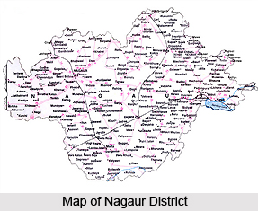
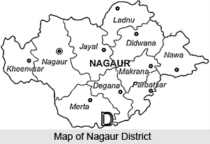
Nagaur District is situated between 26 degrees 25 minutes and 27 degrees 40 minutes North Latitude and 73 degrees 10 minutes and 75 degrees 15 minutes East Longitude. It is situated amidst seven districts namely Bikaner, Churu, Sikar, Jaipur, Ajmer, Pali and Jodhpur. Nagaur is the fifth largest district in the state of Rajasthan with a vast terrain spreading over 17,718 Sq.Kms. Its geographical spread is a combination of plains, hills, sand mounds and as such it is a part of the great Thar Desert in India. The present district of Nagaur finds a place in the heart of the Rajasthan state.
History of Nagaur District
Glorified by the bards, the history of Nagaur finds mention even in the Mahabharata. The kingdom of Ahichhatrapur which Arjun is said to have conquered and subsequently offered to his Guru Dronacharya, was perhaps some of the area of the Nagaur district.
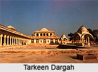
 The birth place of Meera and Abul Fazl, Nagaur district has a charbhuja and Parsawanath Temple at Merta and the Dargah of Sufi Saint Tarkin at Nagaur city. Nagaur also witnessed the valour of the Great Rao Amar Singh Rathor who challenged the rulers of the mighty Mughal dynasty. The large old Fort has many glorious tales of bravery of the erstwhile rulers of the states.
The birth place of Meera and Abul Fazl, Nagaur district has a charbhuja and Parsawanath Temple at Merta and the Dargah of Sufi Saint Tarkin at Nagaur city. Nagaur also witnessed the valour of the Great Rao Amar Singh Rathor who challenged the rulers of the mighty Mughal dynasty. The large old Fort has many glorious tales of bravery of the erstwhile rulers of the states.Geography of Nagaur District
 Geography of Nagaur District is a combination of plains, hills and sand mounds as it is a part of the great Thar Desert in India located in West Indian state- Rajasthan.
Extension of Nagaur District
In terms of size, Nagaur district ranks fifth among the different districts of Rajasthan. The vast terrain of the district spreads over a total area of over 17,718 Sq Kms.
Climate of Nagaur District
The climate of Nagaur district is characterised by a dry climate and hot summer. Generally, one can find in the district extreme dryness, large temperature variations and a highly variable rainfall. Sand storms are quite common in summer. From the month of March to June, the temperature keeps rising steadily. These are therefore the hottest months in the district of Nagaur. The maximum temperature recorded in the district is 47 degrees Celsius with 0 degrees being the lowest recorded temperature. The average temperature of the district is 23.5 degree Celsius. The winter season in the district extends from mid November till the beginning of March. Here, monsoon is of a short duration, from July to mid September. The average rainfall in the district is 36.16 cm and humidity stands at 51.5 percent.
 Geography of Nagaur District
The district of Nagaur is poor in forest resources. The total forest area, including hills, is reported to be 240.92 Sq. kms. which is 1.3 percent of the total geographical area of the district. Scanty rainfall and other geographical constraints account for this. The western part of the district is devoid of natural vegetation cover except for low shrubs and grass which grows on low sand dunes. However, the south-eastern part of the district and part of the northern tehsil of Ladnun and Didwana have much more greenery as compared to north-west part of the district. Khejri trees are commonly found in the district. Its leaves are used as fodder. It also gives gum. Apart from commercial value, this tree is considered holy. The tree also plays an important role in checking soil erosion. The other common species found in the district are babul, neem tree, shisham tree, peepul tree, rohira tree, kalsi, dhangood, akara etc. Rohira and shisham trees provide timber and are used for making furniture.
Economy of Nagaur District
Dhangood is generally used for making cots. A common shrub, phog, provides building material from its roots and twigs. Common grass found in the district includes bargers, bhambar and many more.
Agriculture of Nagaur District
The district of Nagaur is mainly agricultural in nature. A majority of the people here are involved in the same. Among the major crops grown here are bajra, wheat, jowar, til, barley and pulses. Other crops grown in the district are taramira, mustard and rape seeds and gram. The major part of the food production is made up of Kharif crops, as agriculture is mainly monsoon-dependent. Kharif crops include bajara, jowar, moong, choula, rice, groundnut, til and guar. Rabi crops are usually sown in November whereas Kharif crops are sown with the beginning of the first rains in July. Industrially, the district is still quite backward on account of the lack of exploitation of natural resources and under developed infrastructural facilities. However this scenario is slowly changing as efforts are being made to improve the industrial scenario of the district.
Demography of Nagaur District
The district comprises of 1596 Revenue Estates (Villages), out of which Merta, Deedwana, Makarana, Parbatsar and Kuchaman are the major towns of the district. The total area of the district is 17,718 Sq.Kms, out of which 17,448.5 Sq.Kms is rural and 269.5 Sq. Kms is urban. As per the 2001 census, the population of the district is 27,75,058 (4,77,337 urban and 22,97,721 rural population) which is 4.91 percent of the total population of the state. The density of population in the district is 157, as against 165 of Rajasthan as a whole. 12, 87,921 persons of the district are literate, out of which 10, 21,314 are rural and 2,66,607 are urban, which makes it 58.26 percent of the total population. Out of this literate population 75.33 percent are males and 40.45 percent are females.
Administration of Nagaur District
 Administration of Nagaur district is carried out by the District Collector. Nagaur district is one of the biggest districts in the state of Rajasthan. The District Collector is aided in the exercise of his functions by two Additional District Magistrates.
Sub Division Offices
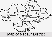
There are nine Sub-Divisional Officers (SDOs) who work at the Sub Division level. They have been appointed with a view to providing administrative support at the local level. There are a sum total of nine divisions in the district of Nagaur. These are: Nagaur, Jayal, Merta, Degana, Deedwana, Ladnun, Parbatsar, Makarana and Nawa.
Tehsils
There are ten tehsil headquarters in this district. Each one of the tehsils has a Tehsildar who acts as the administrative officer. This Tehsildar works in accordance with the land-record system to serve rural farmers and land-holders. The tehsils of the district are Nagaur, Khivnsar, Jayal, Merta, Degana, Deedwana, Ladnun, Parbatsar, Makarana and Nawa. A tehsil contains a number of Patwar-Mandals, each of which has a `Patwari` to serve the landholders and farmers at the village level. There are seven Additional/Sub tehsils namely - Kuchaman, Deh, Maulasar, Sanju, Riyan, Bherunda and Peelwa.
Blocks (Panchayat Samitis)
Nagaur district is divided into 11 blocks (Panchayat Samitis) which are the developmental units. Each block has a BDO (Block Development Officer) to serve as the representives of the district administration in the rural areas. The blocks are Nagaur, Mundwa, Jayal, Merta, Riya Badi, Degana, Deedwana, Ladnun, Parbatsar, Makarana and Kuchaman. Various development works and projects at the rural level (Gram Panchayat Level) are run through Block offices. One Gram Sevak is appointed at each Gram Panchayat to keep record of the development works and to project required development works. Gram Sabha (Village Meetings) is organized at fixed intervals to discuss about development of villages. There are 461 Gram Panchayats in the district.
This is the systematised set up of administration as it is carried out in the district of Nagaur.
Economy of Nagaur District
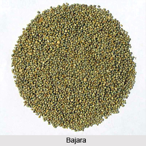 Economy of Nagaur District is primarily dependent on agriculture. Agriculture is the main occupation of a majority of the population of the Nagaur District. Bajra, wheat, jowar, til, barley and pulses are the major crops of the Nagaur District. The other crops of the district are taramira, rape and mustard seeds and gram. Kharif crops constitute the bulk of the food production in the district since agricultural activities are mostly dependent on the monsoons. Kharif crops include bajara, jowar, moong, choula, rice, groundnut, til and guar. Rabi crops are usually sown in November whereas Kharif crops are sown with the beginning of the first rains in July.
The industrial scenario, though not much developed, is slowly moving along the path of development. Earlier, there were minor manufacturers having a market in the neighbouring areas while for the rest of the trades there were hereditary artisans like carpenters, blacksmiths, potters, goldsmiths and other artisans to meet the local demands. Even after independence, Nagaur district has been practically industrially backward on account of the lack of exploitation of natural resources and under developed infrastructural facilities. Now the industrial climate is changing and a number of incentives and concessions are being offered to prospective entrepreneurs and they are looking forward to establish their units in the district.
Industrial units with a fixed capital investment of Rs. 5 crore and above are categorised as large scale industries. There are seven large and medium scale industries which exist in Nagaur district. Inspired by the incentives of the Government, the growth of small scale industries in the district has been quite fast. The major units covered by the small scale sector are mainly food-based industries, agriculture-based industries etc. Some of these units are old and traditional industries. In the recent years, demand and resource-based industries have also been coming up.
Industrial Areas
In Nagaur district, Rajasthan state Industrial Development and Investment Corporation Limited (RIICO) has developed industrial areas and these are located at Nagaur, Merta and Makarana. The district also has three industrial areas of District Industrial Centre (DIC). The principle trade centres of the district are Nagaur, Merta, Nawa, Ladnun, Jayal, Didwana, Parbatsar, Makarana, Degana and Kuchaman city and a number of Krishi Upaj Mandies areas which are also coming up in the district for marketing facilities of agriculture products. Prominent Krishi Upaj Mandies are Nagaur, Merta, Degana and Kuchaman city.
Khadi and Village Industries
The Khadi and Village Industries of the district include leather, tanning and manufacture of leather goods, weaving of cloths, woollen carpets, soap, furniture, rope making etc. Besides, the traditional blacksmiths, carpenters and potters etc. are also seen in most parts of the district. The development of village industries has an important place in the development plan of the state. These have been getting impetus through incentives, mainly in the form of loans being provided by Rajasthan Khadi Gramodyog Board, Rajasthan Financial Corporation, etc.
 Hand Tools Industry
The district of Nagaur claims a certain superiority in the field of hand-tools. Hand-tools Industry has flourished in and around Nagaur over the years. The industry peers into the past, dating almost back 600 years. About 300 types of hand-tools are manufactured catering to the requirements of a wide range of people, from gold-smiths to aeroplane engineers. Though the iron industry has undergone drastic changes, the hand-tools industry remained unchallenged and unmatched. The demand of these hand made tools always witnessed a growing trend. Hand Tools Design, Development and Training Centre (HTDDTC) is engaged in motivating more units to come up.
Salt Industry
Nagaur district is also an important salt producing area, Nawa and Deedwana tehsils being the major salt producing zones. Moreover, the Sambhar area (although forming part of the Jaipur district) is quite close to the salt belt of the Nagaur district. The industries based on common salt area and local resources could sustain, inter-alia, the following kind of plants: Caustic Soda Plant, Soda ash plant, Chlorine gas plant, sodium sulphate plant, iodised salt and refinery.
Gypsum
Nagaur district is very rich in gypsum deposits with Nagaur, Bhadwasi, Bhadana and Manglod being particularly good in Gypsum production. The reserves were estimated to be 952 million tones with 81 percent content and above by the Geographical Survey of India. A substantial part of the gypsum produced hare has been supplied to the Sindri fertilizer factory in Bihar. It has also found its way to Haryana, after primary grinding. An industrial complex in Nagaur, based on gypsum, along with ancillaries could be a major employment provider for the local population. The major Gypsum-based industries are - Cement plan (Portland), Fertilizer plant, Plaster of Paris plant, Potteries and moulds plant and Sulphuric acid plant.
Limestone
Best grade lime stone is found at Gotan, Mundwa, Kathoti and Ambali in the Nagaur district. Lime stone is also available in the Nagaur district in abundant quantity and the quality is reasonably good. Large reserves amounting to about 33 Million tonnes of high grade lime stone are found near Gotan. The deposit near Mundwa contains a reserve of about 1.19 million tones of high grade lime stone. The industries based on limestone as a resource are Quick Lime, Hydrated Lime, Precipitated chalk plants, Mineral Grinding plants and Cement plants.
Wolframite Tungesten
Wolfram (Wolframite) deposits are found in the Renwat hill at Degana. In this mineral, the tungstate of iron and manganese occurs, in the veins or lodes of granite and phtilites. Tungsten is especially suitable for use in the production of alloy steels and high speed cutting steals which retain hardness even when they are red hot. However for small quantities generally low grade materials have been mined. A reserve of the order of 3,400 tones has been established. Other minerals available in Nagaur district include sandstone. It is available almost every where in the district, but the best grades are available at Khatu in Deedwana tehsil where as many as 150 quarries already exist. Fairly good deposits of white clay are found near the village of Suradhana, Khajawana, Mundwa, Dhadhariya Khurd and at a number of other places in Merta Tehsil.
Apart from the mentioned industries, famous traditional crafts industries also flourish in the district of Nagaur. These include the Jatu Saree of Ren, the Bronze Industry of Nagaur, the Leather Mojari of Nagaur and the Durries of Tankla.
Fairs in Nagaur District
 Fairs in Nagaur District are held in a big way. In fact, Nagaur district can be called the land of fairs as they are not only cattle markets but in real terms a way of life. The rural people participate in these fairs very eagerly as if they are big social events. In addition to the cattle routine, a wide variety of objects ranging from needles to nails are also available in these events. Fairs in fact are the true face of rustic rural Rajasthan and are a strong witness of its social harmony.
Some of the major fairs of Nagaur district are discussed below.
Ramdeo Cattle Fair - This is the third largest cattle fair in Rajasthan founded by the great King of the Jodhpur Dynasty, Umed Singh in honour of Shri Ramdeoji 56 years back. The fair continues to be held in the month of Magh (January / February). Although the famous Nagauri bull is the prime attraction of the fair, the indigenous breeds of camel, horses, bullocks, buffalos, goat and sheep are in no way less attractive buys. Traders from all over the country participate actively and vie with each other in purchasing high pedigree animals to upgrade their cattle. The fair is also a rare opportunity for the tourists to see the real rural Rajasthan, rural folk in colourful traditional dresses and turbans in a rural setting. The fair is also a big market of farm products but the Mirchi (red chilli) market is the most thrilling and over-crowded. Folk songs and dances not only entertain the visitors but also tell tales of tradition and heritage. One can`t afford to miss an opportunity to visit this fair.
Baldeo Cattle Fair - It is held in the month of Chaitra (March / April) at Merta city every year. Its history dates back 36 years when this fair was initiated in the memory of the great leader of the farmers Baldeo Ram Mirdha. The Nagauri breed of cattle are traded here in abundance and cattle competitions are the biggest attraction of the fair, providing a glimpse of rural Rajasthan.
Veer Tejaji Fair - This is the second largest fair held every year in the month of Shrawan (August / September) at Parbatsar. It is primarily cattle fair but routine things are also bought and sold. Its history dates back to pre-Independence. Veer Tejaji is known as the protector against snakes, scorpions and mosquitoes. It is said that during the 15 days of this fair these reptiles are not to be seen anywhere in the mela. People believe that Veer Tejaji protects them against the bites of these parasitic reptiles.
Apart from the above mentioned fairs, a number of other fairs are also held in Nagaur district. These include the Sheetla Asthami mela, Hariram baba ka mela, Hanumanji ka mela, Meerabai Charbhuja mela, Parsawanathji ka mela, Sufi Tarkeen Salana Urs, Mataji ka mela, Gusaiji ka mela, Jhulotsawa and the Narsingh Chaturdarshi mela among others.
Tourism in Nagaur District
There are a number of places of tourist interest located in the district of Nagaur. Most of these places have a great history behind them, and date back to ancient times of dynastic rule. Noted among them are Harsolav, Khinvsar Fort, Nagaur Fort, Kharnal, Khatu village etc. Apart from places of historical interest, there are a number of places of pilgrimage tourism located in the district of Nagaur in Rajasthan. Most of these temples themselves are of immense historical value as they have been constructed in ancient times. For instance the Dadhimati Temple built in the 4th century, or the 400 year old Meerabai temple. Other places of pilgrimage in the district include the Panchla Sidha, Bhanwal Matta Temple, Pashupati Nath Temple and Phulabai Temple at Manjhwas etc.
Pilgrimage Tourism in Nagaur District
 Pilgrimage tourism in Nagaur district comprises visiting the many temples that are located here. A number of religious sites dating back to ancient times are found here, such as the Dadhimati temple constructed in the 4th century and the Brahamani Mata temple at Phalvardhika built in the 10th century. Listed below is a brief view of the various places of pilgrimage tourism in the district of Nagaur.
At Jayal, 40 Kms away from Nagaur, is situated the Dadhimati Temple, also known as the Goth-Manglod temple. It is the oldest temple of the district constructed during the reign of the Gupta Empire in India, sometime in the 4th Century. The chief presiding deity here is the Kul Devi of Dadhich Brahmins.
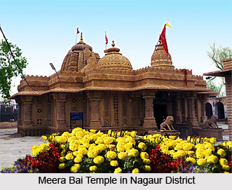
Meera Bai Temple, also known as the Charbhuja temple, is situated at Merta. It is a 400 year old temple. Evidences have been found here as to how total surrender helps attain godly qualities; how deep faith converts poison to `Amrit`.
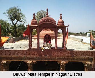
The Bhanwal Matta Temple is situated 25 kms away from Merta city. There is a very interesting story regarding the temple. It is said that when a group of thieves were under threat of life, they prayed to the Mother Goddess for protection, following which the mother made an appearance before them and saved them. The temple was thus constructed as an act of gratitude. The thieves who escaped vowed never to commit theft again.
Phalvardhika (Phalodi) is situated in the Merta tehsil of Nagaur district near Merta Road Railway Station. There is found here an ancient temple of Brahamani Mata known as Phalvardhika Mata belonging to the10th century or even earlier. Some believe that the temple was constructed during the time of the Pratihara Empire.
 The Manjhwas is famous for the Pashupati Nath Temple and Phulabai Temple. It is 20 kms away from Nagaur district. The Pashupati Nath temple is unique in India. The Phulabai temple is dedicated to the saint Phulabai, a devotee of Lord Rama. Phulabai was a saint born in the year 1938 in a Jat family. She was highly devoted to Lord Rama right from childhood and spent most of her time in `Bhakti` and `Kirtana` of Shri Ram.
The village of Ren is situated in Merta Tehsil of Nagaur district, 15 kms. away from Merta city. There is a famous Peeth of the Ram Sanehi community here. It is believed that Adi Acharaya Daryavji of Ram Sanehi Community performed `tapsaya` here. Every year a big fair is held at full noon in the month of Chaitra.
Panchla Sidha is a small village in the Khinvsar Tehsil of Nagaur district, 60 Kms west of Nagaur. It is famous for the Jasnath community. There is a holy shrine called the Siddha Peeth established in the year 1575 Vikram Samwat era, by Siddh Saint Boyatji. There is a Citadel built by Shri Jagat singh, Maharaja of Udaipur. Maharaja Jaswant Singh of Jodhpur presented land to the Peeth for conservation of wild life. This Peeth is devoted to the welfare of the people through spiritual teaching, tantras and yoga. Cultural and religious fairs in the month of February, April and September are held every year, organised by this holy peeth. The major festivals that fall twice a year are a big Jagran and the Agni Nriyta (Fire Dance). In fire dance, followers of the peeth dance bare foot on fire.
Peepasar is a small village in the Nagaur Tehsil of Nagaur district. It is the birth place of the Great Saint Jambhoji, the founder of the Vishnoi community. Khundiyas (Parbatsar) is famous for the temple of `Baba RamdeoJi` in the Parbatsar Tehsil of Nagaur district. Kinsariya is famous for the temple of `Keway Mata` in the Parbatsar Tehsil of Nagaur district.
Leisure Tourism in Nagaur District
 Leisure tourism in Nagaur district is a complete historical exploration as the district abounds in places of historical worth. There are a number of places located here which go back a long way, to the times of kings and dynasties. Consequently, found here a number of forts and ancient villages that bear the legacy of the ancient ages. Apart from this, there other places of leisure tourism located here as well such as the Jain Vishva Bharti Institute, a deemed university which is a famous centre of Jainism. Discussed below are the various places of leisure tourism in the district of Nagaur.
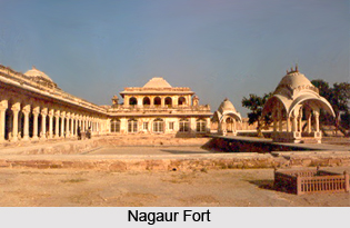
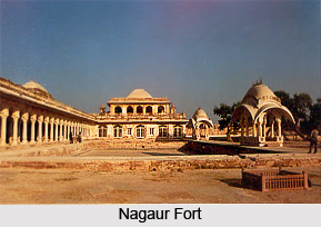
The Nagaur Fort is a sandy fort, centrally located in the district. The fort has lofty walls and a spacious campus, and there are many temples and palaces located inside the fort.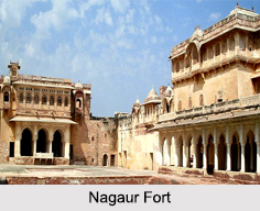 One of the first Muslim strongholds in northern India, the Nagaur Fort is located in the Nagaur district in the Indian state of Rajasthan. Built in the early 12th century, the fort is one of the finest examples of Rajput- Mughal architecture.
Over the subsequent centuries, the Nagaur Fort has witnessed many battles and undergone repeated alterations. Some of the major renovations were done in the year 2007. Currently, there are about 90 fountains running in the gardens and buildings. The fort`s buildings and spaces, both external and internal, serve as venue, stage and home to a Sufi Music Festival.
The Tarkeen Dargah is a most renowned Dargah, next to the Ajmer e Sharif. It is a sacred place for the Muslims and the Sufis. The Jain Temple in Glass is a lofty structure of glass, and a very sacred site for the Jain community. Saiji ka Tanka is the Samadhi of a renowned saint, who inspired in people the quest for the liberation of the soul with simplicity and truthfulness. Other places located nearby are the Cenotaph of Amar Singh Rathore, Bansiwala Temple, Nath Ji ki Chhatri, Barli etc.
Khinvsar Fort is situated 42 kms away from Nagaur on the National Highway No. 65 towards Jodhpur. It is a 500 year old fort in the middle of the Thar Desert in India. The Mughal Emperor Aurangzeb used to stay here. It has now been turned into a hotel furnished with modern facilities. Khinvsar town also has 25 small temples for the tourists to visit. The black deer roaming here in herds are a very popular tourist attraction.
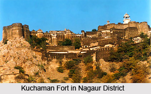
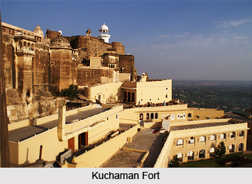
The Kuchaman Fort is located in Kuchaman city. It is one of the oldest and most inaccessible forts of the state of Rajasthan, situated on the top of a straight hill. The fort has a unique water harvesting system. The Jodhpur rulers used to mint their gold and silver currency here. The fort affords a beautiful view of the city. It has been converted into a hotel and is a major attraction among the tourists.
Makarana is a treasure trove of marble. It exemplifies how stones can be shaped and made use of. The marble found here has been used in the construction of famous monuments like the Taj Mahal, Victoria Memorial and other buildings of white stone. The chief source of income for a majority of the people here is marble mining.
Ladnun is the site where the Jain Vishva Bharti Institute (deemed University), a famous centre of Jainism is situated. The institute is a school of thought, a centre of spirituality and purification, a society of Ahinsa and a treasure of tranquillity. Followers believe that it is an abode of humanity on earth.
It is believed that the village of Harsolav is many centuries old. It has an old fort, a temple of Lord Ganesha, a Jain Mandir and a cenotaph of Ramchandra Gurjar which is worth a visit. In the building one can seen beautiful stone carvings. The village is situated on Gothan-Jodhpur road in the Merta tehsil of Nagaur district.
Mundiyad is situated about 25 kms away from Nagaur district in the Nagaur tehsil. The village is centuries old. It is believe that the village was established by Mundra Maheshwari, hence it is called Mundiyad. There is an old Mataji temple and cenotaphs of Jagirdars and Charans of the medieval period. There is also a small Ganesha temple very popular with the people near by.
 The village of Khatu is of great historical interest. The old name of Khatu was Shatkup (six wells). When Shak rulers came to India then they brought two new wells with them which were called Shakandhu (Stepwell) and Kalandh (Rahat). Accoring to Prithivraj Raso, Khatu`s old name was Khatwan. Old Khatu is almost destroyed. Now there are two villages, one is called Bari Khatu and other Chhoti Khatu. On the hillock of Chhoti Khatu a small fort is standing. The fort was built by Prithviraj Chauhan. An old stepwell is located in Chhoti Khatu, known as Phool Bawadi. It is believed that this stepwell was constructed in the Gurjara-Pratihara period. This stepwell is artistic in its style of architecture.
Kharnal is situated on the Nagaur-Jodhpur National Highway, about 15 kms from Nagaur. It is the birth place of Lok Devta Veer Tejaji. It is believed that Kharnal was established by Dhawal Khichi who was the 5th generation of the Choudhan ruler, Gundal Rao Khichi of Jayal state. It is believed that Veer Tejaji was the son of Dhawal Khichi.
Jhorda is situated on the north of Nagaur about 30 kms away. It is the birth place of the Great Saint Baba Hariram and the poet Kandan Kalpit. Every year in the month of Bhadrapad Chaturthi and Panchmi, a big annual fair is held here where about 1-2 lac people participate, coming in from Rajasthan, Uttar Pradesh., Haryana, Delhi and Punjab.
Son Nagar is situated on the north-west border of the district and is a favourite place for foreign tourists who can enjoy the desert life style here. In the village there is a small museum where Rajasthani lifestyle goods are collected and displayed. This village is also famous for its artistic `Kathi`-saddle for camels and horses.
The village of Gogelav was established in the name of Lok Devta Gogaji and it is believed that Gogaji`s Barat (marriage party) had stayed here. In the village there are about 150 Gateways and some of them are very beautiful with stone carvings. Residents of the village are mainly Oswal Mahajans and there are beautiful and big havelies that they have built here. Most of the major Oswal Mahajan families have migrated from here to Kolkata, Chennai and other big cities of India.
Kukri is a small village in the Merta Tehsil of Nagaur district. It is the birth place of the famous princess and poetess, Meera Bai.
These are the various places of leisure tourism that Nagaur district offers its visitors.
Pilgrimage Tourism in Nagaur District
Pilgrimage tourism in Nagaur district comprises visiting the many temples that are located here. A number of religious sites dating back to ancient times are found here, such as the Dadhimati temple constructed in the 4th century and the Brahamani Mata temple at Phalvardhika built in the 10th century. Listed below is a brief view of the various places of pilgrimage tourism in the district of Nagaur.
At Jayal, 40 Kms away from Nagaur, is situated the Dadhimati Temple, also known as the Goth-Manglod temple. It is the oldest temple of the district constructed during the reign of the Gupta Empire in India, sometime in the 4th Century. The chief presiding deity here is the Kul Devi of Dadhich Brahmins.
Meera Bai Temple, also known as the Charbhuja temple, is situated at Merta. It is a 400 year old temple. Evidences have been found here as to how total surrender helps attain godly qualities; how deep faith converts poison to `Amrit`.
The Bhanwal Matta Temple is situated 25 kms away from Merta city. There is a very interesting story regarding the temple. It is said that when a group of thieves were under threat of life, they prayed to the Mother Goddess for protection, following which the mother made an appearance before them and saved them. The temple was thus constructed as an act of gratitude. The thieves who escaped vowed never to commit theft again.
Phalvardhika (Phalodi) is situated in the Merta tehsil of Nagaur district near Merta Road Railway Station. There is found here an ancient temple of Brahamani Mata known as Phalvardhika Mata belonging to the10th century or even earlier. Some believe that the temple was constructed during the time of the Pratihara Empire.
The Manjhwas is famous for the Pashupati Nath Temple and Phulabai Temple. It is 20 kms away from Nagaur district. The Pashupati Nath temple is unique in India. The Phulabai temple is dedicated to the saint Phulabai, a devotee of Lord Rama. Phulabai was a saint born in the year 1938 in a Jat family. She was highly devoted to Lord Rama right from childhood and spent most of her time in `Bhakti` and `Kirtana` of Shri Ram.
The village of Ren is situated in Merta Tehsil of Nagaur district, 15 kms. away from Merta city. There is a famous Peeth of the Ram Sanehi community here. It is believed that Adi Acharaya Daryavji of Ram Sanehi Community performed `tapsaya` here. Every year a big fair is held at full noon in the month of Chaitra.
Panchla Sidha is a small village in the Khinvsar Tehsil of Nagaur district, 60 Kms west of Nagaur. It is famous for the Jasnath community. There is a holy shrine called the Siddha Peeth established in the year 1575 Vikram Samwat era, by Siddh Saint Boyatji. There is a Citadel built by Shri Jagat singh, Maharaja of Udaipur. Maharaja Jaswant Singh of Jodhpur presented land to the Peeth for conservation of wild life. This Peeth is devoted to the welfare of the people through spiritual teaching, tantras and yoga. Cultural and religious fairs in the month of February, April and September are held every year, organised by this holy peeth. The major festivals that fall twice a year are a big Jagran and the Agni Nriyta (Fire Dance). In fire dance, followers of the peeth dance bare foot on fire.
Peepasar is a small village in the Nagaur Tehsil of Nagaur district. It is the birth place of the Great Saint Jambhoji, the founder of the Vishnoi community. Khundiyas (Parbatsar) is famous for the temple of `Baba RamdeoJi` in the Parbatsar Tehsil of Nagaur district. Kinsariya is famous for the temple of `Keway Mata` in the Parbatsar Tehsil of Nagaur district.
Leisure Tourism in Nagaur District
Leisure tourism in Nagaur district is a complete historical exploration as the district abounds in places of historical worth. There are a number of places located here which go back a long way, to the times of kings and dynasties. Consequently, found here a number of forts and ancient villages that bear the legacy of the ancient ages. Apart from this, there other places of leisure tourism located here as well such as the Jain Vishva Bharti Institute, a deemed university which is a famous centre of Jainism. Discussed below are the various places of leisure tourism in the district of Nagaur.
The Nagaur Fort is a sandy fort, centrally located in the district. The fort has lofty walls and a spacious campus, and there are many temples and palaces located inside the fort.
One of the first Muslim strongholds in northern India, the Nagaur Fort is located in the Nagaur district in the Indian state of Rajasthan. Built in the early 12th century, the fort is one of the finest examples of Rajput- Mughal architecture.
Over the subsequent centuries, the Nagaur Fort has witnessed many battles and undergone repeated alterations. Some of the major renovations were done in the year 2007. Currently, there are about 90 fountains running in the gardens and buildings. The fort`s buildings and spaces, both external and internal, serve as venue, stage and home to a Sufi Music Festival.
The Tarkeen Dargah is a most renowned Dargah, next to the Ajmer e Sharif. It is a sacred place for the Muslims and the Sufis. The Jain Temple in Glass is a lofty structure of glass, and a very sacred site for the Jain community. Saiji ka Tanka is the Samadhi of a renowned saint, who inspired in people the quest for the liberation of the soul with simplicity and truthfulness. Other places located nearby are the Cenotaph of Amar Singh Rathore, Bansiwala Temple, Nath Ji ki Chhatri, Barli etc.
Khinvsar Fort is situated 42 kms away from Nagaur on the National Highway No. 65 towards Jodhpur. It is a 500 year old fort in the middle of the Thar Desert in India. The Mughal Emperor Aurangzeb used to stay here. It has now been turned into a hotel furnished with modern facilities. Khinvsar town also has 25 small temples for the tourists to visit. The black deer roaming here in herds are a very popular tourist attraction.
The Kuchaman Fort is located in Kuchaman city. It is one of the oldest and most inaccessible forts of the state of Rajasthan, situated on the top of a straight hill. The fort has a unique water harvesting system. The Jodhpur rulers used to mint their gold and silver currency here. The fort affords a beautiful view of the city. It has been converted into a hotel and is a major attraction among the tourists.
Makarana is a treasure trove of marble. It exemplifies how stones can be shaped and made use of. The marble found here has been used in the construction of famous monuments like the Taj Mahal, Victoria Memorial and other buildings of white stone. The chief source of income for a majority of the people here is marble mining.
Ladnun is the site where the Jain Vishva Bharti Institute (deemed University), a famous centre of Jainism is situated. The institute is a school of thought, a centre of spirituality and purification, a society of Ahinsa and a treasure of tranquillity. Followers believe that it is an abode of humanity on earth.
It is believed that the village of Harsolav is many centuries old. It has an old fort, a temple of Lord Ganesha, a Jain Mandir and a cenotaph of Ramchandra Gurjar which is worth a visit. In the building one can seen beautiful stone carvings. The village is situated on Gothan-Jodhpur road in the Merta tehsil of Nagaur district.
Mundiyad is situated about 25 kms away from Nagaur district in the Nagaur tehsil. The village is centuries old. It is believe that the village was established by Mundra Maheshwari, hence it is called Mundiyad. There is an old Mataji temple and cenotaphs of Jagirdars and Charans of the medieval period. There is also a small Ganesha temple very popular with the people near by.
The village of Khatu is of great historical interest. The old name of Khatu was Shatkup (six wells). When Shak rulers came to India then they brought two new wells with them which were called Shakandhu (Stepwell) and Kalandh (Rahat). Accoring to Prithivraj Raso, Khatu`s old name was Khatwan. Old Khatu is almost destroyed. Now there are two villages, one is called Bari Khatu and other Chhoti Khatu. On the hillock of Chhoti Khatu a small fort is standing. The fort was built by Prithviraj Chauhan. An old stepwell is located in Chhoti Khatu, known as Phool Bawadi. It is believed that this stepwell was constructed in the Gurjara-Pratihara period. This stepwell is artistic in its style of architecture.
Kharnal is situated on the Nagaur-Jodhpur National Highway, about 15 kms from Nagaur. It is the birth place of Lok Devta Veer Tejaji. It is believed that Kharnal was established by Dhawal Khichi who was the 5th generation of the Choudhan ruler, Gundal Rao Khichi of Jayal state. It is believed that Veer Tejaji was the son of Dhawal Khichi.
Jhorda is situated on the north of Nagaur about 30 kms away. It is the birth place of the Great Saint Baba Hariram and the poet Kandan Kalpit. Every year in the month of Bhadrapad Chaturthi and Panchmi, a big annual fair is held here where about 1-2 lac people participate, coming in from Rajasthan, Uttar Pradesh., Haryana, Delhi and Punjab.
Son Nagar is situated on the north-west border of the district and is a favourite place for foreign tourists who can enjoy the desert life style here. In the village there is a small museum where Rajasthani lifestyle goods are collected and displayed. This village is also famous for its artistic `Kathi`-saddle for camels and horses.
The village of Gogelav was established in the name of Lok Devta Gogaji and it is believed that Gogaji`s Barat (marriage party) had stayed here. In the village there are about 150 Gateways and some of them are very beautiful with stone carvings. Residents of the village are mainly Oswal Mahajans and there are beautiful and big havelies that they have built here. Most of the major Oswal Mahajan families have migrated from here to Kolkata, Chennai and other big cities of India.
Kukri is a small village in the Merta Tehsil of Nagaur district. It is the birth place of the famous princess and poetess, Meera Bai.
These are the various places of leisure tourism that Nagaur district offers its visitors.


