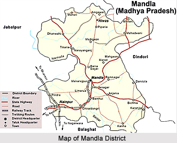
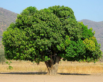
 Mandla District is one of the dominated districts in Madhya Pradesh. The district lies almost entirely in the catchments of Narmada River and its tributaries. Mandla District is located in the east-central part of Madhya Pradesh. It forms the eastern part of the Jabalpur District. Mandla District forms a part of Satpura mountain range, which separates the cotton growing southern region from the wheat growing extension of the Malwa Plateau on the north, and is the watershed of three district river systems. There are 9 development blocks, 4 tehsils and 1247 villages in the district.
Mandla District
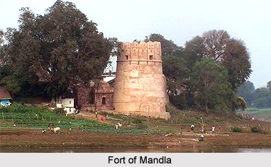
Mandla District is a tribal district situated in the east-central part of Madhya Pradesh. Mandla District is popularly considered as a district with a glorious history.
Introduction
Mandla District is one of the dominated districts in Madhya Pradesh. The district lies almost entirely in the catchments of Narmada River and its tributaries. Mandla District is located in the east-central part of Madhya Pradesh. It forms the eastern part of the Jabalpur District. Mandla District forms a part of Satpura mountain range, which separates the cotton growing southern region from the wheat growing extension of the Malwa Plateau on the north, and is the watershed of three district river systems. There are 9 development blocks, 4 tehsils and 1247 villages in the district.History of Mandla District
 History of Mandla District in Madhya Pradesh states that from 1818 AD to 1835 AD, Mandla was considered a tehsil of Seoni District, whereas Ramgarh (now Dindori tract) and Sohagpur (now in Shahdol District) were included in Jabalpur district. In 1840 A.D. Mandla was also transferred from Seoni to Jabalpur District. It was upgraded to the status of a district in the year 1849 but only six months later is was reverted to its old position. Finally, in 1851, Mandla, Ramgarh and Sohagpur were united to constitute the independent district of Mandla. It was put under the charge of a Deputy Commissioner.
Further, according to the history of Mandla District, at the commencement of the Sepoy mutiny 1857, the chief of Ramgarh(Princely State of Ramgarh), Shahpura and Sohagpur joined the mutineers. When order was restored, Sohagpur was transferred to Rewa District and the estate of Ramgarh and Shahpura were confiscated. In 1858, after some unsuccessful attempts of Mutiny, British administration was firmly established at Mandla District. Moreover, numerous changes were made in the territory of the district. In the year 1867, on the formation of Balaghat district, 262 villages of Ramgarh-Bichhiya were transferred from Seoni District to Mandla. Originally, the district had only two tehsils namely Mandla and Ramgarh.
The present Dindori tract was known as Ramgarh till the year 1904, when it was given its present name. In 1892, the first Indian civil service officer in the state was appointed as the deputy commissioner and was posted at Mandla. In 1914, a third tehsil Niwas was formed with headquarters at the village with the same name. Prior to May, 1998 Mandla District was divided into six tehsils, namely Mandla, Nainpur, Bichhiya, Dindori, Niwas and Shahpura. It was also divided into three sub-divisions for revenue and general administration purposes. Mandla sub-division comprised Bichhiya, Nainpur and Mandla tehsils, while Niwas sub-division had Niwas and Shahpura tehsils. Dindori was the eastern sub-division which had only Dindori tehsil.
With the promulgation of Madhya Pradesh Reorganisation of the District Act, from 21st May 1998, Mandla District has been bifurcated into Mandla and Dindori District. Dindori and Shahpura tehsils and Mahandwani Development Block formed Dindori District while the rest of the area existed in Mandla District.
History of Mandla District also suggests that this region played a great role in the freedom struggle of the country. After the momentous session of Nagpur Congress in December, 1920, the Central Provinces were grouped into three committees, which were later called the Vidarbha provincial Committee, Mahakoshal provincial Committee and the Nagpur provincial Committee. This alignment of province on the linguistic principles had a significant effect on the growth of the Freedom Movement every where including Mandla. The Freedom Movement continued to gain its rhythm in Mandla District as elsewhere.
Geography of Mandla District
 Geography of Mandla District in Madhya Pradesh consists of a rugged high tableland in the eastern part of the Satpura mountain range. The most important range of the Satpura ranges in the district is Maikal Hills, which forms a watershed between western and eastern parts of the state. It is well known in ancient Sanskrit Literature as the source of Narmada River. The spurs and sub-ranges of the Maikal hills divide the region in the east of the district into a number of valleys and table-lands.
There is low altitude in the south-west corner of Mandla District which consists of a compact block of about two hundred good villages, known as the `Haveli` or the rich and wheat-growing tract round Hirdenagar, and `Pathar` or the open wheat plain round Nainpur. The extreme upper valley of the Narmada in Dindori and Niwas tehsils is an undulating plain, without much forest, broken by curious flat topped hills, which enclose patches of fertile black soil. A long spur of the Amarkantak, starting from north to Shahpura, separates the upper Narmada valley from the narrow, but fertile valley of river Kharmer.
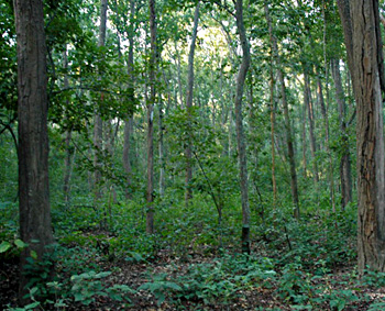
To the south of the Kharmer valley lies the fine plateau containing the Baiga Chak and a long and rugged strip of Sal forest. The mean height of this plateau is over 850 metres. In Niwas tehsil, Narmada River flows through a rugged and inaccessible tract between high, rocky banks, till it enters the level rice tract near Mandla. Thereafter, it traverses through nearly 30 kms of the forest and hill country, and runs almost parallel to the Mandla-Jabalpur District road for few kilometres. The southern portion of the eastern Mandla tehsil is covered by the undulating grass plains of Raigarh District -Bichhiya tract. In this area are the forest sanctuaries of Kanha Tiger Reserve and Kisli - the home of countless deer and antelope and variety of other wild fauna, which attract tourists from everywhere. This tract is spotted with several isolated blocks of Sal forests of the Phen and Banjar valleys.
Mandla District extends over the highest plateaus of the Satpura ranging from 500 metres to 500 metres above mean sea level. Thus, the climate of Mandla District is characterized by hot summer season and general dryness except in the southwest monsoon season. The year may be divided into four seasons. The cold weather season from December to February is followed by the hot weather season from March to about the middle of June. The period from mid-June to September is the southwest monsoon season. October and November constitute the post monsoon or retreating monsoon season. There is a steady increase of temperature after February. May is the hottest month with the mean daily minimum temperature at around 41 degree Celsius and the mean daily minimum at 24 degree Celsius. On individual days during the summer season, the day temperature may go above 44 degree Celsius.
During the monsoon season, relative humidity generally exceeds 75 percent. The air becomes drive after the withdrawal of the southwest monsoon. The driest part of the year is the summer season when in the afternoons relative humidity is less than 25 percent. During the monsoon, season skies are generally clouded or overcast. In the rest of the year, skies are mostly clear or lightly clouded. Winds are in general light. Southwest monsoon winds blow from directions between southwest and northwest.
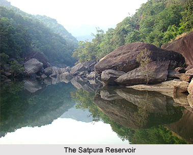
Geography of Mandla District includes several important rivers and their tributaries. Mandla District lies almost entirely in the catchments of river Narmada and its numerous tributaries. The Pathar tract is drained by a small tributary of Wainganga River. It is forming the southwest boundary of the district. The extreme north and northwest of Dindori District tehsil are watered by the Johilla River and Mahanadi River, which eventually find their way into Ganga River. The Narmada flows along the greater part of the district and Banjar is one of its main tributaries.
Narmada is the principal river of Mandla District. It rises at Amarkantak in Shahdol District and enters the district from the north-eastern side. The actual source of the Narmada is a spot of great sanctity. In its winding course through the district, the river generally flows between high and rocky banks, except for some distance near Mandla, where it flows through a rich and fertile plain. Near Mandla the river flows on a rocky bed and so numerous are its currents that this place has come to be known as Sahastradhara or thousand flow. The main tributaries of the Narmada in the district are the Banjar, the Halon, the Burhner, the Kharmer, the Balai, and the Hingara.
 Banjar is the most important tributary of river Narmada in the district. Its basin contains some of the best Sal forests of the district. Helon a tributary of Narmada waters the plains of Raigarh-Bichhiya. Kharmer a tributary of Narmada River waters the plains in the middle and south of Dindori tehsil. It flows eastward for 55 kms along a narrow valley and joins the Narmada at Keolari. Gaur river, which rises in Mandla district, forms for a short distance its boundary with Jabalpur District, and joins the Narmada in the latter district. In addition, the Narmada River also receives the waters of innumerable smaller streams throughout Mandla District. Among the southern tributaries, mention may be made of Machnar, Chakrar, Seoni District and Tar, which drain the northern slopes and valley of Maikal hills. Narmada and its tributaries are usually confined between rocky banks, sometimes rising to over 30 meters in height.
Geography of Mandla District mainly comprises Archaeans, Lametas, and Deccan Traps of recent formation. The older metamorphic rocks of the district include granite, granite gneiss`s, hornblende Schist, quartz, mica schist, lime-silicate rocks, Pegmatite and Charnockite. The Dharwarian rocks of Mandla District are represented by Chilpi Ghat group, which comprises phyllite, dolomites, quartzite, pegmatite, mica schist and quartz. Arenaceous limestone resting horizontally on the denuded surface of schist deacon trap is the most extensively developed formation of the district. In many places, traps are covered by laterite in which segregation of alumina has resulted in bauxite deposit.
The overflowing trap mainly covers Mandla District, and its geology presents a little variety. Several minerals occur in the district. The high-grade dolomite occurs in the west of Banjar River. Low-grade iron ore occurs in Amwar village of the district. Fuller`s Earth and clay occurs at several places of the district. Good quality limestone, mica and bauxite of metallic grade are also found here.
Demography of Mandla District
 According to the Population Census in India in the year 2011, Mandla District had population of 1,053,522. Out of which the males and female were 525,495 and 528,027 respectively. The population of Mandla District constituted 1.45 percent of total population of Madhya Pradesh. The population density of Mandla district is 182 people per sq. km. The Mandla district administers 5,800 square kilometres of areas. The average literacy rate of Mandla was 68.28 percent. The male and female literacy rates were 79.49 and 57.20 percent respectively. The total literates in Mandla District were 620,481. Out of which the male and female literates were 359,137 and 261,344 respectively.
Culture of Mandla District
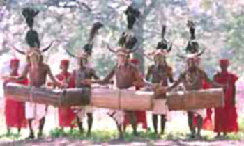
 Culture of Mandla District is tribal in character. According to the census report, Gond tribe and Baiga tribe are most significant tribes in Mandla District. In comparison to the other tribes, Gonds are well settled and economically better than any other communities of the area. Gonds were earlier mostly forest-dwellers but are at present settled agriculturists. Gonds follow tribal endogamy and clan exogamy. Monogamous marriage is common among the Gonds but polygamy, is not altogether unknown. Cross-cousin marriage (both paternal and maternal) is preferred. Parallel cousin marriage has not been observed. They follow the system of patriarchy. Remarriage and widow marriage is also permitted. The Baigas are the most primitive and interesting forest tribal of Mandla district.
In the tribal societies of Mandla District, clans are usually named after some animals or plants. Among the common clans in different districts are Markam (Mango tree), Tekam (Indian Teak tree), Netam (the dog), Warkara (wild cat) and so on. From these animals and plants a clan derives its name. The worship of ancestors is an integral part of their religion. The Gonds have a highly developed aesthetic sense and celebrate a number of festivals. The influence of various leaders under different situations is also observed. Gonds have a tribal council to settle local disputes of internal nature such as conjugal infidelity and other social matters while they settle the extraneous matters in the presence of Mukadama i.e. the village headman.
Folk dance, folk songs and folk music play vital role in the cultural life of the tribal groups in Mandla District. It is through music and dance that they keep themselves occupied in the evenings. Folk music and dance give expression to their innermost feelings, their joys and sorrows, their natural affections and ideals, their appreciation of beauty of nature and war. Every season and every socio-religious ceremony has specific songs. On the occasions of their important religious festivals and marriages, they are found dancing and singing whole day and night.
Folk dances of the tribal communities are popularly called as `Karma`. Karma is the name of the plant commonly grown in that area. Before beginning the ceremonial dance a stem of the plant called `Karam Kalla` is buried in the ground and the dancing troupe dance around this plant. The festivals of Gonds are not so much associated with religion as is the case with most Hindu festivals. Their festivals are in response to the harvest season and local customs. In a whole, their festivals tend to be recreational rather than spiritual. Their festivals are also connected with agricultural cycle. Throughout the year, a number of fairs, festivals and feasts are organised in the village. However, their distribution over a year is rather irregular.
 Hareli Festival is the festival of rain. It is observed in the early period of rains. This is mostly celebrated in the month of July-August. Hareli word is probably derived from Hindi word, `Haryali` which means greenery as in this season vegetation begins to bloom and there is greenery all around. Khyania is another important festival of the region.
Melamadai is a huge fair that is held after the completion of the harvesting of the paddy crop, when the people are free from their agricultural work and their stores are full with grain. After Diwali this fair is enjoyed daily for a week. The head of the village inaugurates the Mela.
Chait Gal festival starts from `Sharad Purnima` usually in October and continues up to the `Kartik Purnima` till November. Nawa Feast and Bidri (Bidri in India) ceremony are other popular celebrations of tribal communities of Mandla District.
Economy of Mandla District
The economy of Mandla District relies mainly on forests and other natural resources like the timber and as well as tourism in this district. Kanha Tiger Reserve is one of the Mandla`s most famous tourist attraction sites.
Tourism in Mandla District
The Kanha National Park is located in the Mandla district. This National Park is one of the most tourist attractive sites for both the domestic as well as foreign tourists. Kanha becomes a land of Royal Bengal Tiger, a home for more than 100 tigers. The area of Kanha Tiger Reserve is 1945 square. Kilometres. Kanha is a destination for wildlife visitors from all over the world for its pride the Royal Bengal Tigers and other animals.
This Reserve is governed under the Wildlife Protection Act of 1972 and the reserve rules. The "Project Tiger in India" is one of the largest Tiger conservation schemes in the world. It was launched in India in 1973 with the objectives to ensure the maintenance of a viable population of the tiger in India. It has also the objective to preserve, for all times, such areas as park of our national heritage for the benefit, education and enjoyment of future generations. Kanha was among the first nine tiger reserves included in the "Project Tiger Network" in 1973. Kanha has fame itself by bringing back from an imminent extinction the Central Indian Swamp Deer also called Barasingha. There are only 66 specimens of the sub-species were left in 1970. Scientific management and strict monitoring has recovered the population to around 330 specimens. In Kanha National Park, there are some other animals found like Chital or Spotted deer, Sambhar, Barasingha, Barking deer, Chousingha, Gaur, Langur, Wild pig, Jackal, Sloth bear and Wild dog. There are around 260 species of birds identified there. The Birds like Peafowl, Jungle fowl, pained spur fowl, grey partridges, Painted Partridges, Indian roller, Racket tailed drongo, Red wattled lapwing, Yellow wattled lapwing.
This Reserve is governed under the Wildlife Protection Act of 1972 and the reserve rules. The "Project Tiger in India" is one of the largest Tiger conservation schemes in the world. It was launched in India in 1973 with the objectives to ensure the maintenance of a viable population of the tiger in India. It has also the objective to preserve, for all times, such areas as park of our national heritage for the benefit, education and enjoyment of future generations. Kanha was among the first nine tiger reserves included in the "Project Tiger Network" in 1973. Kanha has fame itself by bringing back from an imminent extinction the Central Indian Swamp Deer also called Barasingha. There are only 66 specimens of the sub-species were left in 1970. Scientific management and strict monitoring has recovered the population to around 330 specimens. In Kanha National Park, there are some other animals found like Chital or Spotted deer, Sambhar, Barasingha, Barking deer, Chousingha, Gaur, Langur, Wild pig, Jackal, Sloth bear and Wild dog. There are around 260 species of birds identified there. The Birds like Peafowl, Jungle fowl, pained spur fowl, grey partridges, Painted Partridges, Indian roller, Racket tailed drongo, Red wattled lapwing, Yellow wattled lapwing.
Recently updated articles in States of India

History of Thissur District
Early History of Thissur District explains flourishing of the port cities. Now these port cities are transformed into archaeological sites.

Tippi Orchid Research Centre, Arunachal Pradesh
Tippi Orchid Research Centre in Arunachal Pradesh is renowned for its rich collection of exotic and endangered orchids. Surrounded by lush rainforest...

Tourism in Nashik District
Pilgrimage tourism in Nashik district involves visiting the various places of Hindu and Jain worship located here. Some of the holiest sites for Hind...

Mangadu, Kerala
Mangadu in Kerala’s Kollam district is a significant megalithic site known for its urn burials, cist burials, menhirs, and stone circles. Excavations...

Devaswom
History of Devaswom is not very ancient and can be dated back to late seventeenth century.
Related articles in States of India

East Indian States
East Indian States comprises of Bihar, Jharkhand, West Bengal, Odisha and also the Union Territory of Andaman and Nicobar Islands. It defines the cult...

Purnia District in Bihar
Purnia District is located in Bihar and extends from River Ganga to Nepal. The district has a rich Hindu history and glorious past.

Hooghly district
Hooghly District along the bank of the river Hooghly is one of the principal trading ports of West Bengal.

Geography Of Chittoor District
Geography of Chittoor district is spread along the topography of the land which is divided into two natural divisions; Chittoor has a dry and healthy...

Districts of West Bihar
Districts of West Bihar is comprised of medieval monuments that were built by the different governors of Mughal era.