Tourism in Dhanbad District is famous for exquisite natural beauty and renowned pilgrimage sites. Some of the places also hold immense historical significance. The places attract a large number of tourists and pilgrims. Rest houses have also been constructed for them. Dhanbad also houses some very ancient temples and historical structures which have still retained their beauty.
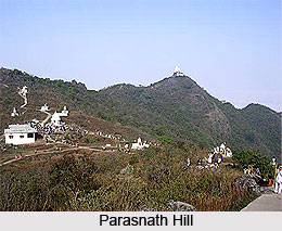
Topchanchi : Topranchi is a beautiful tourist site located near Dhanbad district. It houses an artificial lake at the base of
Parasnath Hill, excavated in 1915. It is created with the purpose of supplying water to
Jharia. Gomoh is another site located near
Topchanchi Lake. It is the place from where Netaji
Subash Chandra Bose embarked on train while departing from India on 18th January 1941. An idol of Netaji has also been established in Topchanchi market to honour the event.
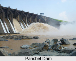 Panchet Dam :
 Panchet Dam stands on
Damodar River. It is situated in Panchet area of Dhanbad district. It was inaugurated in the year 1959 and is the fourth multipurpose dam in the first phase of
Damodar Valley Corporation. It has a backdrop of Panchet hill which makes it a beautiful tourist and picnic spot. The dam is mostly visited at the end of monsoon or start of winter when the dam has high water level and the gates are opened for letting the water out.
Panrra : Panrra is a village located in Nirsa-cum-Chirkunda block. Local myths say that the place has been named after
Pandavas who hided here for some time during their exile. It houses an ancient temple of Pandeweshar Mahadev, dedicated to
Lord Shiva. It was believed to be constructed by a Hindu king.
Shakti Mandir : Shakti Mandir is situated in the district, at the heart of Dhanbad city.
Goddess Durga is the presiding deity of the temple and regular kirtans, jagrans and bhajans are performed in the temple. The temple also hosts an Akhand Jyoti, brought from Jwaalaji pilgrimage of
Himachal Pradesh.
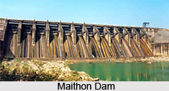 Maithon Dam :
 Maithon Dam stands over
River Barakar. This 15,712 ft long and 165 feet high dam was constructed with the aim of generating electricity and controlling flood. Fishing and boating facilities are available in the dam. It also houses an underground power station which makes it unique for being the only dam having such a feature in Southeast Asia. An island stands at the centre with a tourist rest house. Near the dam other tourist sites include a bird sanctuary, a deer park and Awake Temple, an old temple at Kalyaneshwari.
Charak Pathar : Charak Pathar is a village situated in the development block of Govindpur of Dhanbad district. The place houses an old white stone boulder known as Charak Pathar, from which the place has derived its name.
Chati Gobindpur : Chati Gobindpur is located in the development block of Govindpur. The village houses two old pillars associated with the Afghan Chief, Sher Shah and Emperor
Ashoka.
Gopalpur : Gopalpur village is located in Nirsa-cum-Chirkunda development block. It also hosts an ancient pillar belonging to the time of Emperor Ashoka. A large stone idol of Emperor Ashoka is also situated here.
Jhinjhipahari : Jhinjhipahari village lies in
Baghmara development block. The mines of this area have rendered an old temple of Lord Shiva.
Chark-Khurd : Chark-Khurd is another village in the district famous for its hot spring.
Tourist sites of Dhanbad also serve as popular picnic spots. Apart from temples, dams are also significant tourist spots. Dams, in addition to serving utilitarian purposes, also serve as inviting tourist and picnic sites owing to their mesmerizing scenic beauty.
 The district can be divided into three broad natural divisions, viz., (I) the north and north western portions consisting of the hilly region, (ii) the uplands containing coal mines and most of the industries and (iii) the remaining uplands and plains lying to the south of the Damodar river consisting of cultivable flat lands . The north and north western division is separated for the entire length by the Grand trunk road.
 Dhangi hills are located in the western middle region between the grand chord line of the


