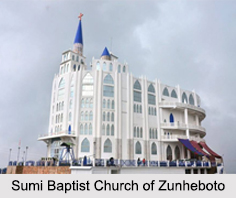
 Located at an elevation of 1,852 m, Zunheboto is a town in the state of Nagaland. The Sumi Baptist Church, which is the largest Baptist church in Asia, is located in the town of Zunheboto. The official languages spoken in the region are Sumi and English.
Etymology of Zunheboto
The town of Zunheboto is inhabited by the Sumi Naga tribe, who speak in a Sumi dialect. In the local vernacular of the region, the word Zunheboto is derived from the term "zunhebo", which is the name of a flowering shrub called Leucosceptrum. This flowering plant grows abundantly in the region and the town was built atop the hills, hence the name Zunheboto as "to" or "ato" means hilltop.
Geography of Zunheboto
Spreading over an area of 1,255 sq. km, Zunheboto also serves as the headquarters of the Zunheboto district. It is bounded by Mokokchung and some parts of Tuensang in north, Kohima and Phek in the south, Wokha in the west, Kiphire and parts of Tuensang in the east.
Climate of Zunheboto
Zunheboto lies north of the Satoi Range, which is a natural habitat for the Blyth"s tragopan, the state bird. Due to the high altitude, Zunheboto experiences a moderate version of a humid subtropical climate. The annual average temperature of the region is 16 degree Celsius with an average rainfall of 1868 mm. The warmest month of the year is July, with an average temperature of 20.3 degree Celsius. The month of January has the lowest average temperature of the year that is 9 degree Celsius.
Demographics of Zunheboto
As per the reports of Census India 2011, the total population of Zunheboto is 22,809, where males and females constitute 55 percent and 45 percent respectively. Children between the ages of 0 to 6 years old make up 14 percent of the total population. The average literacy rate is 85 percent, which is higher than the national average of 74 percent. The male literacy rate is 81 percent and female literacy rate is 77 percent.
Visiting Information on Zunheboto
The Dimapur railway station and the airport are the closest at a distance of about 223 km and 217 km respectively from the town of Zunheboto.


