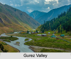
 Gurez Valley is a beautiful valley which is popular as an adventure destination in Kashmir. In the ancient times, it used to be the gateway to the Silk Route. The mighty Neelum River (also called "Kishanganga") flows through the valley. Gurez Valley is surrounded by snow capped mountains. It has diverse fauna and wildlife including the Himalayan brown bear and the snow leopard.
Location of Gurez Valley
Gurez Valley is at a distance of about 86 kms from Bandipora and 123 kms from Srinagar in northern Jammu and Kashmir. At about 8,000 feet (2,400 m) above sea level, Gurez Valley is close to the Line of Control (LOC) dividing India and Pakistan.
Geography of Gurez Valley
Gurez Valley is divided into three regions of which two are in Pakistan and one in India. The area from Toabat to Sharda Peeth is administered by Pakistan as Neelum District, and the area between Kamri and Minimarg is part of the Astore District, Pakistan. The area from Toabat to Abdullae Tulail is known as Tehsil Gurez, and is part of Bandipora district, Jammu and Kashmir, India.
People of Gurez Valley
People of Gurez Valley are Dards. They speak Shin language and have their ancestral connection with Gilgit Valley which is now in Pakistan. The feature and attire of the Dards are similar to Kashmiri people of mountain region. Though Gurez is a far flung area but the people of the Dard race have uplifted themselves by the hard work and proper education.
Nearby Attractions in Gurez Valley
Gurez Valley is the ultimate adventure destination to the north of Kashmir. It is a gateway to the famous silk route across central Asia. The pyramid shaped peak named after famous Kashmiri poetess Habba Khatoon is the most fascinating peak of Kashmir. The roar of mighty Neelum River flowing across the valley echoes within the surrounding mountains that give the visitor a tranquil experience of the Gurez Valley.
Visiting Information of Gurez Valley
There are two ways to reach Gurez Valley. One can either take the road from Srinagar and reach Gurez via Razdan Pass, or can also use the Gurez Chopper Service from either Srinagar or Bandipora.


