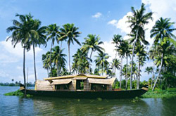
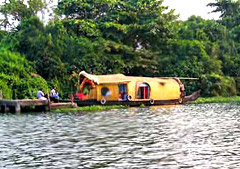
Also termed as Alleppy, Alappuzha laced with the azure brilliance of the Arabian sea and with the web of the flowing rivers is one of the beautiful town, nestled at the Alappuzha District of Kerala. Braided with the scenic beauty of the backwaters, canals, lagoons and beaches Alappuzha is as if a dream turned into reality. The magnificent presence of the dock, the unbroken and sun kissed sea coast has offered a marked dimension to this place whilst making it the "Venice of the East" in the worls tourism map.
Demography:
Alappuzha is the smallest district of Kerala. Area wise its 1,414 Sq.Km, which constitutes 3.64% of the total state area. The population size is 2,105,349, which is 6.61 % of the total state population.Population density is 1492 persons per Sq.Km, against 1415 in 1991- retain the first position in the state.Sex ratio, which is no. of females per 1000 males is 1079 , earning 4th position, previously it was 5th position in 1991 with 1051.Literacy Rate is 93.66 %, which is able to earn a 3rd position in the state. In other State Average cases are 90.92%.Female Literacy rate is 91.14, which again earns 3rd position in the state. While State Average is 87.86%.
Geography:
•North Latitudes - 9o05` and 9o54`
•East Longitudes - 76o17` 30" and 76o40`.
Boundaries:
In North there is Kochi and Kanayannur Taluks of Ernakulam Districts.In East side there is Vaikom, Kottayam and Changanassery Taluks of Kottayam district andThiruvalla, Kozhencherry and Adoor taluks of Pathanamthitta District.In South there is Kunnathur and Karunagappally of Kollam District.In West there is Lakshadweep or Arabian Sea.
Topography:
 The district is a sandy piece of land intercepted by lagoons, rivers and canals. In the eastern portion of the district there are some scattered hillocks lying between Bharanikkavu and Chngannur blocks. Apart from those there are no mountains or hills in the district. Cherthala, Ambalappuzha, Kuttanad and Karthikappally fully lie in low land region. There is no forest area in this district.
Climate:
The climate is moist and hot in the coast and slightly cool and dry in the interior of the district. The average monthly temperature is 250C. The district also gets the benefit of two outstanding monsoons as in the case of other parts of the state.
Hot season starts from March and lasts till May
South-west monsoon (Edavappathi) lasts from June to September,
North-east monsoon (Thulavarsham) starts from October to November; and
Dry weather starts from December and ends on February.
In 1989 it was recorded that the district has 8 reporting rain gauge stations at Arookutty, Cherthala, Alappuzha, Ambalapuzha, Harippad, Kayamkulam, mavelikkara and Chengannur. The average rainfall in the district is 2763 mm.
Soil and crops:
In the taluks of western parts of Cherthala, Ambalapurzha, Karthikappally the main soil is sandy and main crop is coconut. The taluks of Eastern regions of Cherthala & Ambalapuzha, and Western portions of Kuttanad possess Peaty and Kari types of soil. In the taluks of rest of Kuttanad, north eastern portions of Karthikappally, western portions of Chengannur, north western sector of Mavelikkara & the delta region formed by Pamba, Manimala and Achenkovil rivers near its confluence with the Vembanad lake, the main soil is Alluvial and the crops found there are paddy and sugar cane. The soil Laterite is found in the taluks of major portion of Chengannur and Mavelikkara and the main crops that are available there are mainly coconut arecanut, fruit trees, etc. Whereas in the taluks of Cherthala, Ambalapuzha and Karthikappally the main soil is sandy and the main crop is coconut.
Geology:
The geological formations of the district are classified as follows:
•A belt of crystalline rocks of the archean group
•A belt of residual laterite
•A narrow belt of warkalli bed of tertiary group
•A western most coastal belt of recent deposits
The most relevant crystalline rock type is Charnokites. Residual laterite is the resultant product of the insitu alteration of the crystalline rocks. Warkalli beds consist of a succession of variegated clays and sand stone. While the coastal belt consists of recent sediments like aluvium, marine and lacustrine.
Minerals and mining:
 The glass and foundry sand are the two most important minerals that occur in large quantities in the district. Lime shell is exploited commercially. High quality sand deposits occur between Alappuzha and Cherthala, which form a stretch of 35 Km in length along the western side of Vembanad Lake. At Pallipuram large quantities of sand are being mined for manufacturing sand lime bricks. Vast deposits of lime shell occur in Vembanad Lake covering an area of 15 Sq.Km. up to depth of 8 metres between Pathiramanal and Vaikom. China clay and ordinary clay, which occur in various places, are used as building materials. The raw material required for granite carving is obtained from Chengannur.


