 Districts of Central Assam Division include Dima Hasao District, East Karbi Anglong district, West Karbi Anglong district, Nagaon District, Morigaon district and Hojai District.
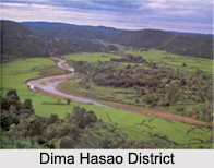
Dima Hasao District
Dima Hasao District, which is earlier called North Cachar Hills district, is an administrative district in the state of Assam. Dima Hasao District is the least populous district of Assam. Dima Hasao District was a part of Dimasa Kachari Kingdom in later medieval era. The kingdom of Dima Hasao was extended from Jamuna in the North to the foot-hills of Lushai Hills in the south and from the Kopili in the west to the Angami and Katcha Naga hills beyond the Dhansiri in the east. The Dimasa Kachari kings had their capitals successively at Dimapur, Maibang, Kashpur, and, lastly, at Horitikor. In 1830, the Dimasa king Gobinda Chandra Hasnu was assassinated by his own general Gambhir Singh, after that the British East India Company annexed the southern part of the kingdom on 14th August 1832 under the Doctrine of Lapse. The rest of Dima Hasao was ruled by last Dimasa General Tularam. In 1837, a portion of Tularam`s kingdom was further annexed to the British Government in India and constituted into a sub-division of Nagaon district in 1837 with headquarter at Asalu. In 1854, on the death of Tularam, the remaining portion of his kingdom was finally annexed to the British Government in India and added to the Asalu sub-division.
East Karbi Anglong District
 East Karbi Anglong district is a new district formed out of the existing Karbi Anglong District of Assam in 2016. Diphu is the headquarter of the newly formed district. The district is a part of Karbi Anglong Autonomous Council, Diphu and it is administered according to the Sixth Scheduled of the Indian Constitution.
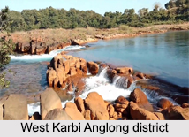
West Karbi Anglong District
West Karbi Anglong district is a new district formed out of the existing Karbi Anglong District of Assam in 2016. Hamren is the headquarter of the newly formed district. The district is a part of Karbi Anglong Autonomous Council, Diphu and it is administered according to the Sixth Scheduled of the Indian Constitution.
Nagaon District
Nagaon is an administrative district in the state of Assam in India.
Morigaon District
Morigaon district is an administrative district in the state of Assam. The district headquarters are located at Morigaon. Morigaon district occupies an area of 1,550 square km and has a population of 957,853 of which males and females are 485,328 and 472,525 respectively.
Hojai District
Hojai District is a new district in the state of Assam, in India. It was formed on 15th August 2015. Hojai is the headquarters of the new district. Hojai district is formed with three thesils of Nagaon district named Hojai, Doboka and Lanka.


