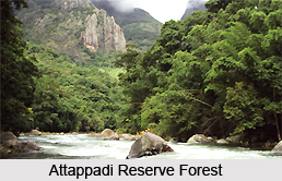
 Attappadi Reserve Forest, situated in Mannarghat Taluk in Palakkad district of the south Indian state Kerala, is a protected area encompassing an area of about 249 square kilometres. In the east it is bordered by Coimbatore district of Tamil Nadu whereas in the west it is bordered by Karimba-I and II, Pottassery-I and II and Mannarghat revenue villages. Palghat taluk forms its southern border and Nilgiri hills margins its northern region. The forest exhibits mesmerizing landscapes. It hosts a government farm which shelters a black goat breed called Attappadi black. In fact the place derives its name from the same. Bhavani River meanders through the forest from Northwest towards the Southeast feeding the natural wealth of the forest. The mountains of the region are known for diverse rocks which have been categorized into 7 broad types.
Geography of Attappadi Reserve Forest
Attappadi Reserve Forest is the beautiful confluence of forest, mountains and rivers. It is an informal buffer zone located adjacent to the Silent Valley National Park. In the year 2007, 81 square kilometre area of the reserve forest was made a part of the newly formed Bhavani Forest Range which in turn is included in the Silent Valley Buffer Zone. The altitude of Attappadi Reserve Forest ranges from 750 meters to 1664 meters. The rainfall in Attappadi Reserve Forest is quite high in the southwest portion and measures about 4700 millimetres but reduces eastward to about 900 millimetres. The Malleswaram peak forms the highest point of the forest. The tributaries of Kaveri River also feed the highland terrains of the forest.
Attractions of Attappadi Reserve Forest
Attappadi Reserve Forest is quite significant for anthropologists as it serves as the habitat of tribal communities namely Kurumba, Irula and Muduga. Malleswaram temple, located there, is the site of the celebration of Shivaratri festival during the month of February or March. In the festival, the tribes worship the Malleeswaran peak of the mountain as a mammoth Shivalingam.
Visiting Information
Attappadi Reserve Forest can be approached through frequent local buses from the nearest towns of Nelippathy and Mannarghat and from the Anakkatti village. Palakkad is the nearest railway station while Coimbatore Airport in Tamil Nadu serves as the nearest airport. Private lodges provide accommodation to the visitors. However rainy season is not said to be preferable for a visit to the Attappadi Reserve Forest.
Attappadi Reserve Forest
Attappadi Reserve Forest, located in Kerala, exhibit a magnificent amalgam of mountains, rivers and forests. Malleeswaran peak in the sanctuary hosts the famous Malleswaram temple where Shivaratri festival is celebrated.


