 is one of the cities of the Indian state of Andhra Pradesh. The city was previously known as Cuddapah. The city derived its name from the Telugu word Gadapa which means the `threshold` or `gate`. The name of the city changed from Cuddapah to Kadapa on the 19th of August 2005. The city`s name is so since it is the gateway from the north towards the sacred hill-Pagoda of Shri Venkateshvara of Tirupati. The city well-known for its great personalities during the medieval times which include Pothuluri Veera Bramham, Vemana, Pemmasani Thimma Nayudu, Annamacharya and patronized Telugu lovers like Bishop Caldwell, C P Brown, etc.
History of Kadapa
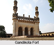
The city of Kadapa was previously a part of the Empire of the Cholas from the 11th to 14th century and it was made a part of Vijayanagar Empire in the latter half of the 14th century. The city of Kadapa was under the dominance of Gandikota Nayaks, who were the governors of Vijayanagar for two centuries. Pemmasani Thimma Nayudu was the most famous ruler during 1422 CE, who developed the area and erected several tanks and temples. The Muslims of Golkonda seized the region in 1565 CE when Mir Jumla attacked the Gandikota fort and overpowered Chinna Thimma Nayudu by treachery. The British later took charge of Kadapa in 1800 CE. Except for a few years in the starting, Kadapa formed the seat of the Mayana Nawabs in the eighteenth century. With the occupation of the British of the tract in 1800 CE the city was made headquarter of one of the four subordinate collectors under the main collector by the name of Major Munro. There still remain the relics of the rule of the Kadapa Nawabs in the city.
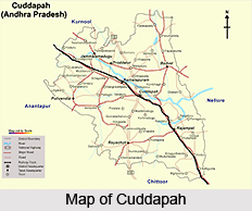
Geography of Kadapa
Kadapa city is situated at 14.47° N and 78.82° E. the city possesses an average elevation of 138 meters or four hundred and fifty two feet. The city of Kadapa resembles the shape of an irregular parallelogram, separated in half by the Eastern Ghat ranges. The city is located in the Bugga or Ralla Vanka in a hollow which is surrounded to the south by the main Palakondas, part of the Eastern Ghats, and to the east by a patch of the same hills casting north for the Lankamalas on Penneru`s other side. Thus, the two tracts formed bear different features. The first part is a low-lying plain which is about 400 ft or one hundred and twenty meters to 450 ft or one hundred and thirty seven meters above the level of sea, constitutes the east, north and the city`s south-east, while the other, which possesses the south-western and southern portion, constitutes a high table-land from 1500 to 2,500 ft above the level of sea.
People of Kadapa
 The city`s population in the year 1901 was 1,291,267 and as per the 2001 India census, the population of the city of Kadapa was 3, 25,725. Male and female have almost equal number in the total population. The average literacy rate of the city was 70 percent, which was greater than the national average of 59.5 percent, with the female literacy rate being 645 and the male literacy rate as 76 percent. In this city, 12 percent of the total population is under the age of six years. The chief languages spoken in Kadapa are Urdu and Telugu. However, English is the major medium of education in several educational institutions in the city.
Education in Kadapa
Andhra Pradesh government has finished a multi crores health project known as the Rajiv Gandhi Institute of Medical Sciences or RIMS at Kadapa which consists of a 750-bed super specialty hospital, a medical college having an intake of 150 students along with a and a nursing college for one hundred students to meet the needs and develop the health of the backward and drought-affected areas of Rayalaseema region. Apart from this, there are several other educational institutions in Kadapa imparting education in diverse fields. Some of the well-known educational institutions in Kadapa are Yogi Vemana University, Balavikas English Medium High School, Little Flower High School, Sri Venkateswara Degree College, Fatima Institute of Medical Sciences, P. Rami Reddy Memorial College of Physiotherapy, Indira Priyadarshini College of Nursing, etc.
Economy of Kadapa
Industry and agriculture are the two major contributing factors to the economy of Kadapa. Korra, lime, orange and betel leaf are cultivated close to the river beds. The major crops are rice, millets, other food grains, oilseeds, pulses, cotton and indigo with indigo and cotton being largely exported. There are various steam factories to press cotton and indigo vats. The city is also known for its mining industry in the state.
Tourism in Kadapa
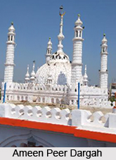
 The ranges of Palakonda are the natural hills which border the city of Kadapa. It possesses good waterfalls and high altitudes which are the major tourist attractions. in Kadapa forms an example of communal harmony preached by famous sages and saints in ancient days. On every Thursday and Friday, a large number of pilgrims from different religious communities visit this three hundred year old shrine in order to get the blessings of Saints Arifullah Hussaini II and Peerullah Hussaini who lie buried here. The Fort Masjid is among the notable masjids in Kadapa which was constructed 400 years ago. It forms a very favourable tourist destination. Apart from these there are several other places of interest in Kadapa including forts, temples, mosques, etc which form some of the notable places of interest in the state of Andhra Pradesh.
The city of Kadapa is adorned amply with the beauty of nature and the temples, forts and mosques which offer a suitable opportunity to explore. Several renowned personalities including, the Late Dr. Y. S. Rajasekhara Reddy, the former Chief Minister of Andhra Pradesh was from Kadapa. With suitable rail, road and air connectivity, the city of Kadapa is counted among the known cities of Andhra Pradesh.


