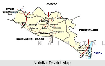
 Geography of Nainital district encompasses both towering mountains as well as plains. Nainital district, in the state of Uttarakhand, is situated at the Kumaon division of the state. Almora district lies towards its north whereas Udham Singh Nagar district is located on its south. Eastern part of the district is bordered by Champawat district and on its western border lays Pauri Garhwal district. Himalayan ranges lies on the northern side and the southern side of the district is flanked by plains. This combination makes the climate quite pleasant.
Nainital district spans over a geographical area of 4251 square kilometres. Two geographical zones divide the district namely Hilly and Bhabar. The outer Himalayan region is termed as the Hilly region. Geologists call it Krol. Baudhansthali forms the highest peak of the district, rising to an altitude of 2623 metres above sea level. It is located near Binayak, adjacent to the town of Nainital. Hilly region of Nainital district houses numerous lakes of big and small sizes. Some of the large lakes of the district are Lokhamtal, Harishtal, Malwatal, Nainital, Khurpatal, Naukuchiatal, Sat Tal and Bhimtal. Bhabar region refers to the foothill area of the district. This region takes its name from a type of tall growing grass which is found in this region. Bhabar region is known for deep levels of underground water.
The main river of the district is Kosi which originates from Koshimool near Kausani. The river flows on the western part of the district. Several rivulets also flow in Nainital district like Baur, Dabka, Bhakra, Gaula etc. Dams have been built on most of these rivulets for irrigation purposes. Rainfall is abundant in Nainital district.
This article is a stub. You can enrich by adding more information to it. Send your Write Up to content@indianetzone.com


