Virar is a city and a municipal council in Thane district in the Indian state of Maharashtra. It is the last station of the western suburb local root. Virar is named after an Indian philosopher Jeevan Virar. An outpost of Mumbai, in the year1925 Virar is connected with mainland with electric train. The other name of Virar is Vasai.
History
The history of Vasai comes from ancient ages. One version of the origin of the name derived from Sanskrit word, which means "Waas" or Residence.
The Portuguese influence is specially noticeable in Vasai/Virar. When Marathas invaded and colonized the region, they named it as Bajipura or Bajipur. But it did not stick; when England conquered the region from Marathas in the year 1774, they named it as Bassein region, which is now called Vasai.
Bassien was an important trading center of that time. From 15th Century it was ruled by Portuguese, followed by Diu and British.
Geography
 Vasai is located at 19.35° N to 72.8° E. it is an average elevation of four kilometer. The climate of the city is tropical. During summer Virar city`s humidity level was very high and during winter the season is almost dry . Monsoon rains lashes the city from June to September.
Economy
For several centuries people of Virar depend upon agriculture. Since 1980 people `s land in areas like Virar, Nala Sopara were either taken forcibly or forced to sell at very cheap price by gangsters. As a result people are gradually moving from agriculture to other means for livelihood. The prime harvested corps are Rice, Banana, Coconut, Vegetables, and Flowers.
Transport-
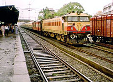
Virar is well connected with Mumbai city. Mumbai`s western line railway connection is link with this city.
Division
Modern Vasai is divided in to two parts as east and West. Vasai East is generally called as the part of eastern side of Western Railway Track line. It is known for its blooming industries and Vasai west stretches from the railway tracks to the western coast. Now the main center lies in the westren side.
Demographics
As per 2001 Census, vasai had a population of 49,346. Male constitute51% and female 49% of the total population. Vasai has an average literacy rate of 77%, higher than the national average of 59.5%. Male literacy is 81% and female literacy is 73%. In Vasai, 11% of the population is under six year of age.
 Culture
Vasai mainly consists of four major communities. 1. Kupari 2. Christi vadvals, 3. Vadvals, 4. Samvedic Brahmins Kupari.
Kuparis are mostly from northern Vasai. The population is about 40,000 to 45,000. The language spoken by Kupari community is called Kadodi or Samvedic, which is mix dialectic of Marathi, Marwari and Konkni with very few words derived from Portuguese. Samvedic Brahmins are also uses this language.
Now 60% of the population in Virar belongs to Christian Community. Followed by 39% Hindus.
Most of the Christian populations are Roman Catholic and the remaining minority is a mixed population of various Christian Protestant sects. The Christian community came into existence during the period of Portuguese in 15th century. At that time most of the Samvedic Brahmins converted into Christian.
The several churches, temples of Hindu and Jain of Virar are included as major visiting places.
The famous churches are
•Holy Cross Church
•St. Thomas Church
•
Our Lady Of Grace Cathedral.
•Our Lady Of Remedies
•Fatima Church
•St. Paul Church
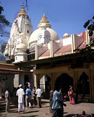
 The famous Temples are
•Jivadani Temple
•Vajreshwari Temple
•Mahalaxmi Temple
•Ekvira Temple
•Sri Dattatreya Temple
•Shain Temple
•Vittal Temple
The other picnic spots for beach outgoings areSuruchi bag, Arnala,Kalamb, RanGaon and Kelve Mahim.
Historical places of Virar
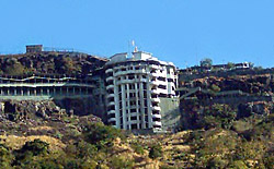
Vasai Fort- This fort was initially built by Bahadurshah of Gujrat and further developed by Portuguese.
Arnala Fort- In the year 1516, a local chieftain in Gujrat, Sultan Mohamad Begda has originally constructed the fort on the island, strategically located at the mouth of Vaitarana river.
Buddhist stupas- Some 2500 years back, the modern day region of Nalasopara was known as `Suparak`. It was then the capital of `Sonaparant` and it was thriving commercial port town. Trade roots to countries like China, Ceylon and Japan were well established from Suparak.
Phadke wada, Jawahar Palace, Asherigad, Gambhirgad are few other attractive places in Virar.
Educational Institute of Virar
•John XXIII HighSchool
•Shastri Vidyalaya HighSchool
•Utkarsha Vidyalaya, Virar.
•Viva College of Arts,Science and Commerce.
•National English highSchool
•M.G.M Academy HighSchool
•Little Fairy Montesery, Virar


