 Barapali is a town as well as a notified area committee situated in the administrative district of Bargarh in the state of Odisha in eastern part of the Indian subcontinent. Barpali includes the people of Gopaipali, Badgaon, Kainshir, Dhirpur, Barangpali and Kadalipali.
Location of Barapali
The district headquarters are located in the city of Bargarh. The district of Bargarh is the western most district of Odisha.
Geography of Barapali
Barapali is surrounded by the state of Chhatisgarh in the north, Sambalpur District in the east; Balangir and Subarnapur are in south, and Nuapara in the west. The total area of the district is 5837 square Kms.
Demography of Barapali
The total population is 1,345,601, while the population density of the district is 231 persons per square km. The Bargarh district was formed from the former district of Sambalpur.
Economy of Barapali
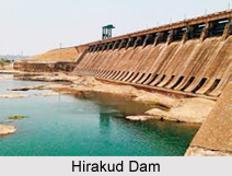
Barapali has the agricultural economy. The Hirakud dam on the Mahanadi River provides irrigation all through the year making the northern half of the Bargarh District rich in agriculture. The main crop grown here is rice.
Culture of Barapali
The nearby settlements of Barpali include Gopaipali, Badgaon, Kainshir, Dhirpur, Barangpali and Kadalipali. Barapali is the land of culture. This area is famous for Dhanu Yatra. A distinctive feature of the district is a ten day long open- stage drama, Dhanu Yatra, based on the life and times of Lord Krishna, terminating in the death of King Kansa. The district is also well-known for its centuries` old handloom industry manufacturing a characteristic textile form called Sambalpuri. The main language of the people is Sambalpuri, a dialect of Oriya. The great Oriya poet Gangadhar Meher was born at Barpali.
Tourism in Barapali
Barapali has the agricultural lands and the temples to attract the tourists. There is a temple at Nrusinghnath constructed in the 13th century, where Lord Vishnu is worshipped in a feline incarnation. This is a unique feature of the temple. Barapali has presence of Goddess Samalei and has its own importance in the temple which is of worth visiting. Sital Sasthi is another important point here. This festival has completed more than thousands of years.
Related Articles
Odisha, Indian state
Bargarh District
Chhatisgarh
Hirakud Dam


