Introduction
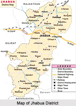 Jhabua is a predominantly tribal district located in the western part of Madhya Pradesh. The total area is 6793 square kilometres. There are about 1313 inhabited villages. It can be said about Jhabua District that it is an overwhelmingly tribal and poor district.
Geography of Jhabua District
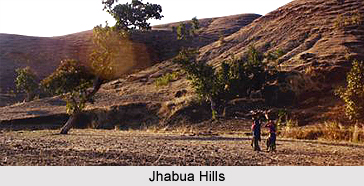 Geography of Jhabua district is rarely covered by forests because of its less fertile land. The district of Jhabua in the state of Madhya Pradesh is surrounded by the Panchamahal district and Vadodara district of Gujarat, Banswara district of Rajasthan and Dhar district and Ratlam district of Madhya Pradesh. Narmada River forms the southern boundary of the Jhabua district. The terrain is hilly, undulating typically known as `Jhabua hills topography`. In this Jhabua hill topography the difference between the highest and the lowest points varies between 20 meters to 50 meters. But this difference goes on increasing as one moves towards south of Jhabua district. In Alirajpur division, which is in the south of the district of Jhabua, the areas is almost entire hilly and intersected by narrow valleys and low Vindhayan ranges covered with jungles. But a major portion of the district of Jhabua is without any forest cover because of low fertility of land and soil erosion.
The total geographical area over which the district of Jhabua is spread is 6793 square kilometers. The total area of this district covered by forest is 645 square kilometers. The Jhabua district is devoid of vegetation cover except Katthiwada and other patches and is full of undulated, hilly areas. The area of this district suffers from poor and skeletal soils with shallow to very shallow depth and erratic rainfall, high temperature, etc. The area comes under Agro-climatic zone number twelve, namely Jhabua hills covering an area which is 1.5 percent of the total geographical area of Madhya Pradesh. The district has three distinct sub zones which are Petlawad (Malwa), Katthiwada (High rainfall) and Jhabua (Low rainfall) zones.
The district of Jhabua in Madhya Pradesh state enjoys a moderate climate and seasons here are well defined. The summers are usually hot, winters are short and the monsoon season is generally pleasant. The average rainfall received by this district is about 800 millimetres. Most of the rainfall occurs during the monsoon season while there is also little rainfall in winter season. The Narmada River is the largest river of the Jhabua district. It flows from east to west along the southern boundary. Some of the other rivers flowing in this district include the Hatni River, Mahi River, Anas River, etc.
Climate
Climate is generally moderate and seasons are well defined. The summers are hot, winters are short and the monsoon season is generally pleasant. The average rainfall in the district is about 800mm. Most of the rainfall occurs in monsoon season while there is also a little of rainfall in winter season.
Demography of Jhabua District
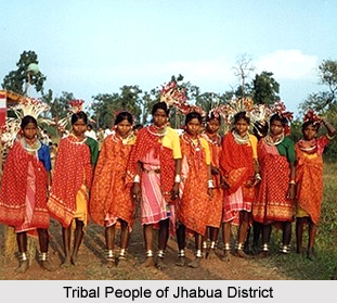 Jhabua is sparsely populated area with the total population of 13.94 lakhs according to 2001 census. About 85% of population is tribal while 3% population belongs to Schedule Castes. 47 per cent of the people live below the poverty line. The literacy rate according to 2001 census is 36.87% with female literacy of only 4%.
Culture of Jhabua District
Jhabua District is inhabited by the tenacious and hardworking tribes - the Bhil Tribe and Bhilalas, the district is highly drought-prone and degraded waste lands form the face for Jhabua. Although almost half of the population lives below the poverty line, the tribals still revel in their traditional colourful festivities and continue to make merry on the occasions like "Bhagoriya". The women make lovely ethnic items including bamboo products, doll, bead-jewellery and other items that have for long decorated the living rooms all over the country. The men have since ages adorned "Teer-Kamthi", the bow and arrow, which has been their symbol of chivalry and self-defence.
Tourism in Jhabua District
 Jhabua District of Madhya Pradesh is sparsely populated and most of the population of the region is a tribal population. But the district has importance in terms of tourist spots. Certain regions in Jhabua District of Madhya Pradesh have added to the value of the district. The Tourist spots of Jhabua have religious, historical and natural importance as well. Some of the prominent tourist destinations of Jhabua are Bhabhara, Deojhiri, Lakhmani Gram, Malwai and Amkhut.
Bhabhara
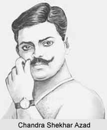
It is a village in jobat Tahsil lying at a distance of 32 kilometres north-west of Jobat on Jobat-Dohad Road. The place is popular as a tourist destination because the famous freedom fighter, Chandra Shekhar Azad was born in Bhabhara. Presently a small memorial has been erected in his Bhabhara in this honour.
Deojhiri
Deojhiri as the name of the village denotes there is an ancient temple of Lord Shiva (Deo, a diety) and jhiri or a perennial spring. The spring has been built up into a kund. A samadhi is held on Baisakh Poornima, which falls mostly in the month of April according to Gregarian calender.
Lakhmani Gram
Lakhmani gram is a small village located on the bank of the Sukar River. There is a newly constructed Jain temple in this village. The village has come in to prominence among archaeologists, historians and lovers of plastic art in about 1925 when the Jain images enshrined in this temple were unearthed accidentally from a field. The images have been carved out of milky-white marble and black marble called sanmoosa. In addition images of Hindu deities and remains of Hindu temple have also been found. The sculptures belong to the style of 10th-11th century. Since the recovery of the images the place is held as a tirth (Holy place) and an annual fair is held.
Malwai
Malwai settles on the northern foothills of the Vindhyachal Range in Alirajpur Tahsil. There is an ancient but small Shiva temple in ruinous condition. The platform of the temple is rectangular but several conical columns rising from the base reach up to the kalash, which has presently fallen. The front portion of the cone has also fallen. Many beautiful carvings and images in the row of Penals are visible which can be assigned to 12th-13th century.
Amkhut
Amkhut is located among the forests of the Vindhachal range. It enjoys a natural beauty and cool climate. The Canadian Christian Mission has established its centre here amidst the tribal villages.


