Introduction
 Saharanpur district lies in the northern part of the Doab region. It is primarily an agricultural area.The district headquarters are Saharanpur town and it belongs to Saharanpur Division. Saharanpur attained the status of Saharanpur Division in 1997 of Uttar Pradesh.
History of Saharanpur District
 History of Saharanpur District states that the physical features of the district have proved that the region was fit for human habitation. The archaeological survey has proved that the evidence of different cultures is available in this area. The excavations were carried out in different parts of Saharanpur District namely Ambakheri, Bargaon, Hulas, Bhadarabad and Naseerpur etc. A number of things have been found during these excavations, on the basis of which, it is established that in Saharanpur district, the earliest habitants were found as early as 2000 BC. As per the history of Saharanpur District, this region is connected with Indus Valley Civilization. It is stated that Ambakheri, Bargaon, Naseerpur and Hulas were the centres of Harappa culture because many things similar to Harappan civilization were found in these areas.
From the days of Aryans, the history of Saharanpur region is traceable in a logical manner. The history of the area goes back to ages. With the passage of time its name changed. During the reign of Iltutmish, Saharanpur became a part of the Slave Dynasty. Muhammad Bin Tughlaq reached northern Doab to crush the rebellion of Shivalik Kings. There he came to know about a Sufi saint on the banks of `Paondhoi` river. He met him and thus ordered that henceforth the place should be called as `Shah-Harunpur` by the name of Saint Shah Harun Chisti.
Akbar was the first Mughal ruler who established civil administration in Saharanpur and made it `Saharanpur-Sarkar` under Delhi province and appointed a Governor. The Jagir of Saharanpur was honoured to Raja Sah Ranveer Singh who founded the city of Saharanpur. At that time Saharanpur was a small village and served as army cantonment area. The nearest settlements at that time were Shekhpura and Malhipur.
Further, the history of Saharanpur District describes that this region passed to the British in 1803. The founders of Darul Uloom Deoband, actively participated in the rebellion, organized the masses outside Delhi and, for a while, were successful in ousting the British authority from the area of their operation. The centre of their activities was Shamli. After 1857, the cultural and political history of Muslims revolved around Aligarh and Deoband. They wanted to achieve religious and social consciousness by peaceful methods. Deoband Madarsa was making efforts for promoting nationalism. Thus, the district became centre of activity of Deoband School Ulama. The school played an important role in the revolutionary activities organized for the country`s freedom.
Geography of Saharanpur District
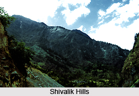 Geography of Saharanpur District presents many varieties of features and differs in general appearance than any other portion of the Doab and Gangetic plain as a whole. Saharanpur District forms the most northerly position of the Doab land which stretches between Ganga River and Yamuna River. Shivalik Hills rise above it on the northern frontier. The portion of Doab in which Saharanpur is situated was probably one of the first regions of upper India occupied by the Aryans colonizers as they spread eastward from Punjab. It is true that most of the area belongs to the upland Bangar which stretches in a continuous line up to Allahabad. Geography of Saharanpur District also includes low lying valley full of swamps and back waters with wide open grass plains and Tamarisk jungle. But in the north there are the steep hills of Shivalik chain which appear in a far more marked form in Saharanpur than any other district of Uttar Pradesh.
Yamuna is the important river of the district. Apart from this Solani, Hindon, Ratmau, Nagdev have also played an important role in the physical reconstruction of the district. All the rivers of the district submerge either in Yamuna or in the Ganges. Saharanpur District has a tropical climate because of the proximity of the Himalayan region across this district. It is sub-humid region especially the upper Ganga plain areas. Saharanpur District records an average temperature around 23.3 degree during the course of the year. June is the hottest recorded month while January is the coldest one. Humidity is more in the western area as compared to the eastern region of Saharanpur.
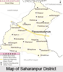
As regards its physical features the north and the north east portion of Saharanpur District is surrounded by Shivalik hills and separates it from Dehradun District of Uttaranchal. River Yamuna forms its boundary in the west which separates it from Karnal and Yamunanagar districts of Haryana. In the east lies Haridwar District which was the part of district Saharanpur before 1989 and in the south is district Muzaffarnagar. The main characteristics of geography of Saharanpur District can be divided into four parts - Shivalik Hill Tract, Bhabar Land, Bangar Land and Khadar Land.
The region is very poor in mineral resources. Limestone stone boulders are the only main minerals. Limestone is found in the Shivalik hills. The physical features and the climatic conditions of Saharanpur District have played an important role in shaping its history and making it an important part from the rest of the country.
Economy of Saharanpur District
Agriculture plays an important role in the economy of the Saharanpur district. Roughly 70 % of the land is under agricultural use. The significance of commercial crops have increased manifold as a consequence of sugarcane production. The important food crops of the region are wheat, rice, maize, jawar, bajara, sugarcane, oilseeds, cotton and jute are the main commercial crops.
Even though Saharanpur district does not have enough mineral resources many agro-based industries have developed in the region. Here sugar industry and paper, paperboard industry is found. Saharanpur is famous for its wood carving industry. The Shivalik range provides the raw material for the industry. Woodwork is exported to countries like Germany, UK, USA, Canada, Kuwait, Sweden, Singapore and many others. Besides exporting goods from here the region also imports Coal, iron - ore, cement, salt, petroleum products, fertilizers, oil - seeds and leather from Punjab, Haryana, Rajasthan, Delhi and Bihar.
Governance of Saharanpur District
District Magistrate heads the revenue and criminal jurisdiction. Additional District Magistrates, City Magistrate and Sub divisional Magistrates, Tehsildars etc. is being deputed to help him in maintaining revenue and criminal jurisdiction. ADM (Executive) assists in general administration while ADM (F & R) assists in the matter of revenue administration, stamps, revenue recovery etc. City Magistate is responsible to maintain and enforce law and order in the City Area.
Divisions of Saharanpur District
Saharanpur Division has two districts in its under namely, Saharanpur and Muzafarnagar.Saharanpur District has four Sub-divisions. They are- Saharanpur, Deoband, Nakur, Behat.
Demographics of Saharanpur District
As per1991 Census of India, Saharanpur district had the population of 2,309,029. Male consists of 1247.25 and female consists of 1061.78. It has an average literacy rate of 64%, higher than the national average of 59.5%: male literacy is 67%, and female literacy is 60%.
Culture of Saharanpur District
Saharanpur District has a special position from the religious point of view. Although there are many famous temple and religious places in Saharanpur Shakti Peeth Shakumbari and Deoband have a unique important from the historical point of view.
Shakti Peeth Shakumbari:
It is situated at a distance of 40 Kilometer to the north of Saharanpur. The Devi temple situated in Shakumbari area dates back to ancient times although there is no concrete historical and archeological evidence. Twice a year in the month of Ashwin and Chetra the famous Shakumbari mela is organized during the days of Navratra. About Shakumbari it is believed that the Devi performed Tap for 100 years having a vegetarian meal only once every month end. During this the Rishi Munis who came for Devi`s Darshan were welcomed and honoured with vegetarian meals. Because of this the temple was named as Shakumbari Devi temple. About one kilometer east of Shakumbari lies the Bhura Dev (Bhairav) temple, which is considered to be the guard of Shakumbari Devi.
Shakti Peeth Deoband:
Along The Saharanpur-Muzaffarnagar Highway lies a small town of Deoband. Thousands of years back, a very dense forest existed here. Since, this forest served as a residence of Goddess Durga, it came to be known as Devi Van, which was later named as Deoband. According to another belief, since goddess Durga had killed `Asur` Drug here, she was worshipped here by many `Devtas` (Gods). It is because of this Devi-Vandan, this place got its present name.
To the east of Deoband lies a large ancient lake, which is widely, know as Devi-Kund. It is said that Devi Durga had killed the Maha Asur Durg at this kund only. A temple of Bala Sundari has been built near this Devi Kund in the memory of the above event, which is a famous center for the worshippers of goddess Durga. Every year a large festival (mela) is organized here in Chaitra Shukla Chaturdashi. Innumerable devotees throng this place to take a dip in the holy waters of this Kund and worship goddess Durga. People believe that Devi of Deoband and Shakumbari are sisters. Devi Kund and the Bala Sundari temple of Deoband are considered as one of the two Shakti Peeths of Saharanpur.
Guggha Veer or Gughal:
Guggha Veer or Ghughal has a great importance in Saharanpur Districts. It is also known, as Jahar Deewan Guggha peer is a religious place situated along the Gangoh road 5 km to the south west of Saharanpur. It is said that the King of Patan (Rajasthan) Raja Kunwar Pal Singh had two daughters Vachhal and Kachhal after marriage Vachhal provided dedicated worship to Guru Gorakhnath to be blessed with a son. But When Guru was providing blessing Kachhal reached there and obtained Guru blessing for two sons, which was, actually meant for Vachhal. Guru Gorakhnath realized this and later gave is blessing to Vachhal in the form of a son Gugghal with the condition that Ghugghal would kill the sons obtained by Kachhal as a result of Guru blessing. Ghugghal was highly disappointed with this and he went to the forest for Tapshya. Guru Gorakhnath was pleased with his Tapshya and blessed him as a Veer.
This place latter came to be known as Ghggha veer ki Marhi since then every year at the time of Shukla Paksh Dashmi in the month of Bhado a large festival (mela) is organized here which is a symbol of Hindu Muslim unity. This festival is popularly known as Mela Ghughal.
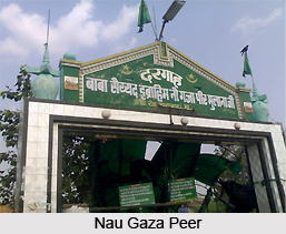
Nau Gaza Peer
Among the different Peer existing in this region Nau Gaza has a unique identity. It has 26 feet long `Mazaar`. The most peculiar features of this Mazaar are that every time this Mazzar is measured it appeared to be of a different size. The Mazaars of the Nau Gaza exists at Gagalheri and Baliakheri.
There are different versions about Nau Gaza. Some Muslim say that during Musa Ale Salam, the height of a man used to be around 26 feet and these Mazar have been built around that time. According the some Hindu scholars in ancient times there existed some saints who could read peoples mind with in 9 Yards distance. Hence they were known as Nau Gaza. Whatever the reason may be, Nau Gaza Peer has a great religious significance in Saharanpur. Every year a large festival (mela) is organized here and thousands of hinds and Muslims visits this place for worship.
Baba Sri Lal Das
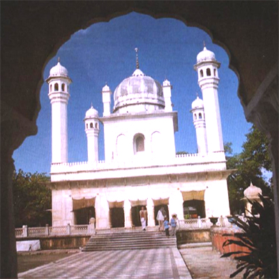
Saharanpur had the distinction of having a noble soul like Baba Shri Lal Das on its soil. Baba Lal Das performed his Tapshya in Saharanpur as a result of which Mughal ruler Dara Shikoh had to bow in front of Indian culture. Baba was born in Kaloor town near Lahore in Pakistan. The great Tapasvi Shri Chetan Swami was his Guru. After obtaining his education from his Guru, Baba came to Saharanpur and performed Tapshya for hundred years. This place in Saharanpur is famous as Bada Shri Lal Das or "Lal Vadi". It is situated along the chilkana road four Km to the north Saharanpur bus station.
Tourism in Saharanpur District
 In Saharanpur, there are many places to visit.
Company Garden:
It is a very beautiful botanical garden once the preserve of the British East India Company.
The Saharanpur Botanic Garden: It is one of the oldest existing gardens in India and dates back to before 1750. Then named Farahat-Baksh, it was originally a pleasure ground, set out by a local chief in the 1770s. In 1817, it was acquired by the East India Company. When the Botanical Survey of India was established in 1887, to reform the country`s botanical science, Saharanpur became the centre for the survey of the northern Indian flora. Overall, the Garden is seen historically as being second only to the Calcutta Gardens in terms of national significance for its contribution to science and economy. Although under private auspices today, it is full of greenery and has many different kinds of plants and flowers.
Ambedkar Park: It is founded by Chief Minister Mayawati, and the wood carvings market at Ambala Road which displays wonderful examples of the art of this city.
Pilgrimage Tourism in Saharanpur District : 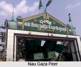 Pilgrimage tourism in Saharanpur District includes visits to several holy shrines and temples. People from far and wide travel to these religious places. Pilgrimage tourism in Saharanpur District offers a memorable experience to the travellers.
Some of the popular religious places of Saharanpur District are :
Shri Baba Lal Das: Baba Lal Das performed his Tapasya in Saharanpur as a result of which Mughal ruler Dara Shikoh had to bow in front of Indian culture. Tapasvi Shri Chetan Swami was his Guru. After obtaining his education from his Guru, Baba came to Saharanpur and performed Tapasya for hundred years. This place in Saharanpur is famous as Bada Shri Lal Das or Lalvadi. It is situated along the Chilkana road four kms to the north of Saharanpur.
Shakti Peeth Shakumbari: Shakti Peeth Shakumbari is situated at a distance of 40 kms to the north of Saharanpur. The Devi temple situated in Shakumbari area dates back to ancient times although there is no concrete historical and archeological evidence. The popularity of this temple has been increasing day by day and millions of devotees visit this temple to offer their prayers. Twice a year that is in the months of Ashwin and Chaitra the famous Shakumbari mela is organized. The idols at Shakumbari temples do not represent a very ancient architecture. Some people believe that this temple was constructed during the Marathas while other believes that Adi Shankaracharya performed his Tapasya here and these idols were installed by him in this temple. It is said that Goddess Shakumbari killed Mahishasura Maha Daitya.
Shakti Peeth Deoband: Along the Saharanpur-Muzaffarnagar Highway lies the small town of Deoband. Thousands of years back, a very dense forest existed here. Since, this forest served as a residence of Goddess Durga, it came to be known as Devi Van, which was later named as Deoband. To the east of Deoband lies a large ancient lake, which is widely, know as Devi-Kund. It is said that Devi Durga had killed the Maha Asur Durg at this kund only. A temple of Bala Sundari has been built near this Devi Kund. This temple belongs to ancient times and this is proved by the fact that the inscriptions engraved on the door of the temple have not been deciphered till now. Every year a large festival (mela) is organized here in Chaitra Shukla Chaturdasi. Innumerable devotees throng this place to take a dip in the holy waters of this Kund and worship goddess Durga. Devi Kund and the Bala Sundari temple of Deoband are considered as one of the two Shakti Peeths of Saharanpur District.
Nau Gaza Peer: Among the different Peer existing in this region Nau Gaza has a unique identity. It has 26 feet long `Mazaar`. The most peculiar features of this Mazaar are that every time this Mazzar is measured it appeared to be of a different size. The Mazaars of the Nau Gaza exists at Gagalheri and Baliakheri. There are different versions about Nau Gaza. Nau Gaza Peer has a great religious significance in Saharanpur. Every year a large festival (mela) is organized here and thousands of devotees visit this place for worship.


