 Except for a small area in the extreme north-west which drains into the Narmada River, the district as a whole lies in the drainage basin of the Tapi. Parallel with the Tapi are three well marked belts of country running east to west; in the centre the rich Tapi valley, in the north the high and wild Satpura mountain range, and the south and southwest bare ridges and well watered valleys separated by spurs of the Sahyadri ranges and innumerable dykes.
The district may be broadly divided into the following natural regions:
the Satpuda region, ii) the Tapi valley proper, iii) the region of dykes and residual hills of the Sahyadri spurs with eastward trending streams in between and, iv) Navapur and western Nandurbar region with a westerly aspect below the Sahyadri scarps.
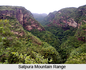
The Satpura region -North of the Tapi, the whole length of the rich alluvial plain is bounded by the steep southern face of the Satpuras, a belt of mountain land about 30 kilometres broad. Much of this hilly country, now with only a few scattered Bhil tribe hamlets, was once peopled. In the wide valleys of Aner river and Arunavati river are the brushwood covered ruins of temples, mosques, wells and single storeyed houses of what once had been considerable towns. Though much is deserted, in the north and north-west the Akrani uplands are well tilled and prosperous, peopled by the Pavras, skilful and hardworking peasants, whose homesteads, each in its plot of fields, are sheltered by well-kept mango and moha groves.
Tapi Valley: The soils of this region are extremely fertile except in some portions near the main river and its tributaries, which have cut down the land very badly and removed the top soil. Otherwise the soils grade from the deep fertile soils to coarse shallow to stony soils away from the river either northwards towards the Satpuras or southwards towards the residual hills and dykes.
Region of dykes and residual hills: This comprises the southern part of Nandurbar and Sindkheda and the whole of Sakri and Dhulia talukas. This region consists of residual hills and dykes of poor dry and stony soils intervened by well watered valleys of the eastward trending upper courses of streams with somewhat better soils and intense agricultural activity based on canal and well irrigation. This region is one of the few regions in Maharashtra with well developed canal irrigation even in pre-British times, probably on account of the rivers flowing in a region of light soils derived from the slow weathering of the dykes. On account of the general inferiority of the soils, the predominant crop is kharif bajra. Cotton and groundnut are also widely grown. In the irrigated valley sections, especially in the Panjhra valley, sugarcane, Cambodia cotton and wheat are raised. In the western section with higher rainfall, along with the above crops, ragi and rice and a little gram are also grown.
 Navapur and western Nandurbar region: This region with a westerly aspect below the Sahyadrian scarps is full of steep hill ranges covered with forests, broken here and there by casual tillage which surrounds the Bhil hamlets. The Sahyadris come to an end in the north-east corner of this sub-region and though they gradually fall away towards the Tapi they form a noticeable feature from the plain lands to the east. The westerly aspect accounts for the higher rainfall of this area (75 to 100 cms) as compared to the rest of the district. The rivers afford a good supply of water throughout the year. In the kharif season rice, tur and jowar are sown in mixtures; after the dry rice is harvested, jowar and tur continue to grow to be harvested later. Ragi (locally known as nagali) is a fourth crop of this region. In the rabi season irrigated and unirrigated wheat and Bengal gram are grown. No groundnut is grown in this sub-region.
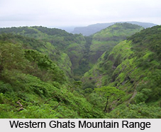
The climate of this district is on the whole dry except during the south-west monsoon season. The year may be divided into four seasons. The cold season from December to February is followed by the hot season from March to May. The south-west monsoon season which follows thereafter, lasts till September. October and November constitute the post-monsoon season. The average annual rainfall in the district is 674.0 mm. The rainfall is heavier in the hilly regions of the Western Ghats mountain range and the Satpura ranges. From about the latter half of February, temperatures increase steadily till May which is the hottest part of the year with the mean daily maximum temperature at 40.7 degrees Celsius. From November, both day and night temperatures drop rapidly till January which is the coldest month with the mean daily minimum at 16.2 degree Celsius. Except during the south-west monsoon season when the humidity is above 70 per cent, the air is rather dry over the district during the rest of the year.


