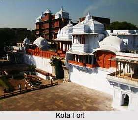
 History of Kota district city goes right back to the 12th century A.D. when the Hada Chieftain, Rao Deva, conquered the territory and founded Bundi and Hadoti. Hadoti region is the south eastern region of Rajasthan, comprising Bundi district, Baran district, Jhalawar district and Kota. The entire region has an extremely rich historical heritage dating back several centuries. Prehistoric caves, paintings, formidable forts and the mighty Chambal River hurtling from the Vindhyas are dotted in the region. Present day Kota owes its foundations to a Kotya Bhil warrior who 800 years ago built a small fortification at Akelgarh and put up a protective mud-wall around it all the way to Retwali. When Jait Singh of Bundi defeated the Bhil Chieftain Kotya in a battle, he raised the first battlement or the `Garh`(fort) over his severed head.
Later, in the early 17th century AD during the reign of the Mughal Emperor Jahangir, the ruler of Bundi, Rao Ratan Singh, gave the smaller principality of Kota to his son, Madho Singh. The independent state of Kota became a reality in 1631 when Rao Madho Singh, the second son of Rao Ratan of Bundi was made the ruler, by the Mughal Emperor Shah Jahan. The district of Kota has since been the stronghold and hallmark of Rajput gallantry and culture.
Soon Kota outgrew its parent state to become bigger in area, richer in revenue and more powerful. Maharao Bhim Singh played a pivotal role in Kota`s history, having held a `Mansab` of five thousand and being the first in his dynasty to have the title of Maharao. Kota is situated on the banks of the Chambal River and is fast emerging as an important industrial centre. It boasts of Asia`s largest fertilizer plant, precision instrument unit and atomic power station nearby. Chemicals, fertilizers, synthetic fibres, tyre cord and sophisticated instruments, industry`s mainstay, have helped in pushing this ancient city into the forefront of modernisation. Yet memories of its ancient links linger strongly.
This article is a stub. You can enrich by adding more information to it. Send your Write Up to content@indianetzone.com``


