About Jhalawar District
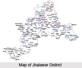 Spread over an area of 6928 sq. km. Jhalawar District is a significant district in the desert state of Rajasthan. It is situated in the southeastern part of Rajasthan at the rim of the Malwa plateau and is also a part of the Hadoti region of Rajasthan. It is the ancient folded mountain region in India, which roughly separates the plains of Hadoti from the Malwa Plateau. The Kota district on the northwest, Baran district on the northeast, the state of Madhya Pradesh in the west and the Mukandra range on the north surround Jhalawar district. The district is the home to many tribes mainly the Meenas and the Bhils. Jhalawar district is well connected to industrial and commercial cities like Indore, Ujjain, Ratlam, Kota and Bhopal.
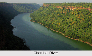
Unlike most parts of Rajasthan, the district is a fertile, lush plain with occasionally rocky, `scrub covered terrain`. The district is drained by a number of rivers. The largest river flowing through the area is Kali Sindh, which later joins Chambal. The other rivers traversing the district are Ujjad, Ahu, Parvan, Chavli.
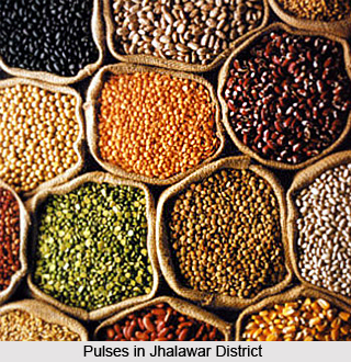
 The region has a climate, which is similar to that of the Indo -Gangetic Plain with hot dry summers and pleasant cold winters. The district receives the highest rainfall in Rajasthan at an average of 943 mm per year. Besides the irrigation dams and ponds the rainfall is of much help to the farmers. The agricultural productivity in the district is very high and some of the important crops grown here are soyabean, wheat, opium, pulses, gram, jowar, paddy and bajra. Jhalawar district is famous for the production of oranges. Infact it has earned the nickname `Small Nagpur` because it comes next to Nagpur in terms of orange production. The region around Bhawani Mandi, Jhalrapatan and Pirawa sub divisions produce oranges, which are exported to various foreign countries. Other than oranges the district exports other items like synthetic yarns, fiber yarns, Kota stone. The district has a number of small scale industries which includes stone polishing and cutting, vegetable oil, wooden furniture, spices, washing powders and many more. A large-scale industry in the district is the Rajasthan Textile Mills.
This unexplored district is a rare combination of undulating terrains one side and dense forests on the other, which makes it an ideal tourist destination. The district is also the storehouse of pre-historic cave paintings, colossal forts, virgin forests and abundant wildlife variety. The important tourist destinations are Bhawani Natya Shala, Buddhist Caves and Stupas, Gagron Fort, Government Museum, Jhalawar Fort, Bhimsagar Dam, Chandrabhaga temples, Manohar Thana Fort, Nageshwar Teerth, Sun Temple. Dag, Dalhanpur, Jhalarapatan are towns in the district also attracts lot of visitors as they are dotted with ancient temples.
History of Jhalawar District
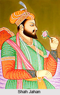 History of Jhalawar district is synonymous with tales of the Hadas, a major branch of the great Chauhan clan of Agnikula Rajputs. Jhalawar is situated in the south-eastern region of Rajasthan, a region widely known as Hadoti (Hadavati), the land of Hadas. In the 12th century A.D., Hada Rao Deva conquered this territory and founded Bundi state and Hadauti. Later in the early 17th century A. D. during the reign of Mughal emperor Jahangir, the ruler of Bundi, Rao Ratan Singh gave the smaller principality of Kota to his son, Madho Singh, but when Shah Jahan became the emperor, he issued a firman in the name of Madho Singh, recognizing as him the King of Kota. The domain of the Hadas of Bundi and Kota extended from the hills of Bundi in the west to the Malwa plateau in the east, with a similar expense from north to south.
The state of Jhalawar was founded on 8 April, 1838, out of the Kota territory. Jhalawar state got rise as a result of a treaty between English rulers, Kota state, and Malwa state. Jhalawar was founded by Jhala Zalim Singh (First), who was the then Diwan of Kota state (1791 A.D.). He established this township, then known as Chaoni Umedpura, as a cantonment. The township was surrounded with dense green forests and wild animals. Jhala Zalim Singh often came here for hunting and he liked the place so much that he wanted to develop it as a township.  The objective to develop this place as a military cantonment was due to the fact that Maratha invaders passed through this central place from Malwa towards Kota to capture Hadoti states. He recognized the importance of this place and started to develop the place as a military cantonment and township, so that he could use this place to attack and stop Maratha invaders before they can reach to Kota state.
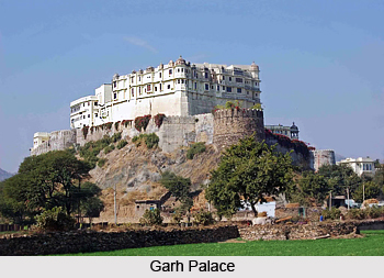
It was around 1803-04 AD that Chaoni Umedpura got developed as a cantonment and township. Colonel Todd, who visited the region in December, 1821 described this area as the cantonment established by Jhala Zalim Singh plus a well-established township with large houses, havelis, and surrounding walls. In the year 1838, the rulers of the British East India Company separated Jhalawar from Kota and handed it over to Jhala Madan Singh, the grandson of Jhala Zalim Singh. He developed his administration services to develop Jhalawar. He resided in Jhalara Patan for a long time and started to build The Garh Palace (1840 - 1845 A.D). He was the first ruler of Jhalawar and made a great contribution in the history of Jhalawar.
Jhala Madan Singh ruled Jhalawar from 1838 to 1845. After his death, Jhala Prithvi Singh became the ruler of Jhalawar, and ruled for around 30 years. Rana Bhawani Singh Ji, who ruled Jhalawar state from 1899 to 1929 A.D., did remarkable work in the development of Jhalawar. He was actively involved in social activities, public works (construction), education, administration, etc. During his time, Jhalawar witnessed much development and modernisation, and he was successful in laying down the groundwork for the district of Jhalawar as it exists today.
Geography of Jhalawar District
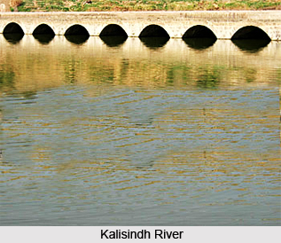 Jhalawar district is situated in the north-eastern part of Rajasthan along the edge of the Malwa plateau. It lies along the border of Rajasthan and Madhya Pradesh, spreading along into neighbouring Madhya Pradesh. Jhalawar district is a rock-strewn, scrub-covered terrain, occasionally covered with fields of poppies and citrus-green groves of oranges. Lying in the south-eastern region of Rajasthan at the edge of the Malwa plateau, Jhalawar has rocky but water-laden verdant landscape, unlike much of Rajasthan. It covers a total area of 6928 Sq. Kms. Jhalawar district is an expanse of fertile plain having rich black-cotton soil. It is watered by several rivers, giving it a verdant look. The largest river flowing through the area is the Kali Sindh River, which flows through the territory to join the Chambal River, Rajasthan`s largest river. Other rivers include Ujaad, Ahu, Parvan, Chavli etc. The Aravalli mountain Ranges, which are the most ancient folded mountain ranges in India, cross the region and roughly divide the plains of Hadoti from the Malwa plateau. These hills and the surrounding areas were once thickly forested and teeming with wildlife.
 The climate of Jhalwar district is very much similar to that of the Indo-Gangetic plain, with hot dry summer and delightfully cold winters. The average temperature in the district during summer is 47 degree Celsius on the higher side and 32.5 degree Celsius on the minimum side. During winter, the maximum temperature is around 32.5 degree Celsius whereas the minimum temperature hovers around 9.5 degree Celsius. The monsoon is, however, quite unlike and most distinct from the oppressive humid climate of the North Indian plains. Jhalawar district is known for the highest rainfall in the state of Rajasthan. An average of 35 inches of rainfall keeps it cool, and gentle breezes ward off the stifling humidity. Lying at an altitude of 460 metres, the district receives an average rainfall of around 943 mm.
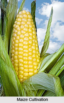
Agriculture is practised in quite a big way in the district. The total geographical area of Jhalawar district is 6.62 lakh hectares, out of which 4.87 lakh hectares is suitable for agriculture and farming activities. Since the district receives the highest amount of rainfall in the state of Rajasthan, it has facilitated the practice of agriculture of the farmers of the region. Besides this satisfying rainfall, the district has a lot of irrigation dams, ponds, and medium scale projects, which are serving the needs of farmers. Among the major crops grown here are soya bean, pulses, jowar and maize in the Kharif lot and wheat, mustard grain and coriander in the rabi season. Jhalawar is also known for the production of Citrus (Oranges). Citrus produced in Jhalawar region are of export-quality, and are exported to various foreign countries.
The district of Jhalawar is well known for its rich forests and exotic flora and fauna. Around 21 percent of the total area is covered by forests. Numerous species of birds can be spotted along the roads, while the Sarus crane breeding grounds spotlight the rich avian life dominating Jhalawar territory. Red poppy fields make up a vibrant colour in the district.
Administration of Jhalawar District
 Administration of Jhalawar district is carried out by the District Collector. Jhalawar district is identified as the 17th district of Rajasthan. Various district level departments and offices are located at the district headquarters. District-level officials work while sitting in Jhalawar. Time-to-time administrative tours are organized to bring up and solve the problems of rural areas. There are Six Sub Divisional Officers (SDOs) who work at the division level to distribute the power at the local level. Jhalawar district has six sub-divisions. These are - Jhalawar, Aklera, Bhawani Mandi, Pirawa, Khanpur and Manoharthana.
The district of Jhalawar is divided into 6 blocks (Panchayat Samitis). Each block has a BDO (Block Development Officer) to serve as the representative of district administration, in the rural areas. The six blocks are at Bakani, Dag, Jhalara Patan, Khanpur, Manohar Thana and Sunel. Various development works and projects at the rural level. There are a number of development works and projects at the rural level, i.e., the level of the Gram Panchayat, which are run through Block Offices. One Gram Sevak is appointed at each Gram Panchayat to keep record of the development works and to project required development works. `Gram Sabha` (Village Meetings) are organized on fixed intervals to discuss about development of villages.
There are seven tehsil headquarters in the district of Jhalawar. The seven tehsils in the district are- Aklera, Gangdhar, Jhalara Pathan, Khanpur, Manohar Thana, Pachpahar and Pirawa. Each one of the tehsils is headed by a Tehsildar, who is the administrative officer of the same. The entire department of the Tehsildars works in accordance with the Land record system to serve the interests of the rural farmers and landholders. A tehsil contains a number of Patwar Mandals. Reach of the Patwar Mandals has a Patwari who serves the landholders and farmers.
 The rural population of India, which makes up almost three-fourths of the entire population, is characterised by low income levels which is not sufficient to ensure a quality of life that is compatible with physical well being. In order to combat this, District Administration in accordance with Central and State governments is spearheading the frontal attack on rural poverty, through its various programs. These programs endeavour to reach out to the most disadvantaged sections of society, and provide them with means of employment and to improve infrastructure relating to their life-supporting system.
The Rural Development and poverty alleviation programmes are implemented on a decentralized basis throughout the country. At the level of the centre, Ministry of Rural Development has been implementing these programs in the rural areas. The Ministry releases the central share of funds, policy formulation, overall guidance, monitoring and evaluation of the programmes. At the level of the state, Secretary of Rural Development is in charge of implementation of the programs. Finally, at the level of the district, the Zila Parishad is responsible for implementing the programs for rural development. The governing body of the Zila Parishad includes the Members of Parliament, the Members of the Legislative Assembly, district level officials of related departments and the representatives of the weaker sections of society. At the level of the blocks, it is the Block Development Officer and at the village levels, the Gram Sevaks who are responsible for the implementation of rural development plans.
The Zila Parishad at the Jhalawar District is accordingly working in keeping with the plans for rural development. There are a number of plans and projects which the Parishad is working on. These include the Vidhayak Sthaniya Kshetra Vikas Karyakram (MLA Local Area Development Program), Swarna Jayanti Gram Swarojgaar Yojana, Awasiya Rin / Anudaan Yojana, Daang Kshetriya Vikaas Yojana, Grameen Vikaas Kendra Yojana
(Rural Development Center Scheme), Samudayik Jalotthaan Yojana, MADA Scheme, Bekunth Dahm Yojana, Shanti Priya Gram Yojna, Dindayal Upadhyay Yojna, Guru Golwolker Yojna, Swa Vivek Yojna and Total Sanitation Programme / Nirmal Gram Yojna.
Economy of Jhalawar District
 Jhalawar district is very rich in the agricultural arena. Major productions in the district are of soyabean, citrus, opium, wheat, and dhania. The prime crops in the kharif season are soyabean, pulses, jowar and maize and the rabi crops are wheat, mustard and coriander. The district experiences the highest rainfall in the state of Rajasthan. This rain is very helpful for the farmers of the region. Besides this satisfying rainfall, the district has a lot of irrigation dams, ponds, and medium scale projects that are serving the needs of farmers. Many of the small-scale industries running in the district are totally dependent on agriculture.
Jhalawar is also known for the production of Citrus (Oranges). It ranks second place in orange production in India after Nagpur, Maharashtra. The area around Bhawani Mandi has the distinction of being an important place on the International and National Citrus (Naarangi) fruit map. Citrus produced in Jhalawar region are of export-quality, and are exported to various foreign countries. Citrus-belt is spread around the Bhawani Mandi, Jhalawar and Pirawa sub-divisions. In order to boost up orange production and to provide risk coverage due to scarcity of water during flowering period, an innovative scheme `Weather Insurance for Oranges` was initiated in the district in year 2004-05.
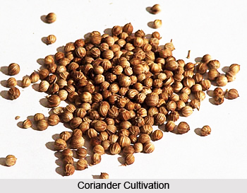
 Jhalawar district also ranks number one in the state in area and production of Coriander.
Looking to immense potential State government has declared Jhalawar along with Kota, Bundi district, Baran and Chittorgarh district as `Agri Export Zone For Coriander`. Encouragement is being given to make proper use of limited source of water by installation of Drip System in orchards.
Industrially the district is doing quite well for itself. Jhalawar district is surrounded by and well-connected to developed industrial and commercial cities like Indore, Ujjain, Ratlam, Bhopal, and Kota. The district has its name in exporting various productions like synthetic yarns, oranges, fibre yarns, Kota stone etc.
District Industrial Centre, Jhalawar
 District Industrial Centre, (DIC) Jhalawar was established in June, 1978. The objective of DIC is to provide guidance, basic services, and financial services/facilities to entrepreneurs and industrialists and to make and activate plans for industrial development in the district. DIC is serving through various plans, services and facilities to rural / urban industrialists and educated unemployed people for the development of Jhalawar district as an industrial centre. Some of the major plans and schemes run by the DIC are- Single Window System, Griah Udyog Yojana, Pradhan Mantri Rojgaar Yojana (PMRY)/PMEGP (Prime Minister Employeement Generation Programme), Margin Money Scheme, to implement various central government / organization plans and schemes through NSIC, IIRD, NABARD, HESCO, Khadi Gramodyog, NISIET Hyderabad etc., organizing various training camps and industrial fairs, utilizing the waste slurry of Kota Stone etc.
Growth Centre, Jhalara Patan
DIC established an industrial growth centre near Jhalara Patan, which has a total of 450 plots for industries. A majority of the plots here have been allocated to industries. Major industries in this growth centre are of Stone cutting and polishing, Steel Furniture and Almirah, PVC shoes, Agricultural accessories, tractor trolleys, electric transformers, etc.
Though the industrial scenario of the district is on a developing path, there are certain steps still to be taken in order to facilitate greater growth of industries. More financial help is required by the industries for getting established in the district. Moreover, primary infrastructure for electricity, water, transport etc is required for accelerating the pace of industrialisation.
Tourism in Jhalawar
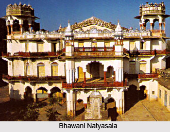
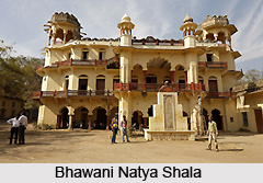 Jhalawar is located at a distance of 85 kilometers from Kota. In the year1838 it was established by Zalim Singh. The picturesque city of Jhalawar is located at the edge of Malwa Plateau. This well laid out city was an important trading center for the Rajputana kingdom in the 19th century. Besides being the commercial hub Jhalawar was also the primary city where music, theater and art flourished. The theater house here is located within the palace and is called Bhawani Natya Shala and was built along the western style opera house. The performing arts thrived here because these received patronage from the royal people.
The whole region is a treasure house of prehistoric cave paintings and formidable forts. In addition to these ancient buildings there are the red poppy fields that add to the picturesque beauty of the place. The lush green fields and those of oranges make Jhalawar more attractive. During winters the place comes alive with greenery all around. Its beauty is indescribable. Amidst such beauty lies the fort built by Maharaja Madan Singh, now housing government offices. It also houses a government museum that has a collection of sculptures, coins, rare manuscripts, a stone inscription dating back to the 5th century and exquisite statues of Ardhanarishwar, Natraj and Trimurti.
Near Jhalawar stands the ancient city of Chandrawati known for its ancient temples of both Hindu and Jain sects. The symmetry of their architectural elements are quite impressive too. Express buses ply regularly from Kota Central Bus Stand. Jhalawar is also a stop over enroute to Indore or Ujjain in Madhya Pradesh. Taxis or rental cars are also available for Jhalawar.
Transportations are easily available from Kota to arrive at Jhalawar. A two hours bus ride will take the travelers to this ancient town. As far as hotels are concerned the travelers can choose from heritage as well as budget hotels. RTDC Gavdi Talab, Prithvi Vilas Palace, RTDC Hotel Chadrawati, Hotel Dwrika and others are there for the purpose.
Pilgrimage Tourism in Jhalawar District
 Pilgrimage tourism in Jhalawar district is full of trips to temples. There are a number of ancient temples located here, dedicated to Hindu and Jain gods. These are remarkable sculptures housing some very old deities of antiquity, such as the 100 year old Parshwanath statue at the Jain Swetambar Nageshwar Parshwanath Temple. The various places of pilgrimage tourism in the district of Jhalawar are discussed below.
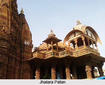
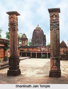
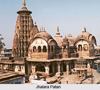
Jhalara Patan is also known as the `city of temple bells.` Situated about 7 Kms away from Jhalawar, the entire township is located within a wall. Founded by Parmara Chandra Sen, grandson of Maharaja Vikramaditya, it is located on the banks of the holy Chandrabhaga River. Colonel James Todd mentions counting 108 temples here. Enclosed within its old walls is the famous 10th century 100-feet high Surya Temple. The temple is full of lovely sculptures. Nearby is the beautiful group of temples on the Chandrabhaga stream which rises from a spring. They belong to the 6th - 14th centuries. The 11th century Shantinath Jain temple and Shri Dwarkadheesh temple (built by Jhala Zalim Singh) are among the other important temples here. Just nearby to Dwarkadhish temple, newly developed Herbal Garden and Choupati are also worth a visit.
 Bhimgarh-Kakuni: On the banks of the Parwan River are the ruins of an old township with a huge idol of Lord Ganesha and an 8th century Shivlinga. The temple ruins are well worth a visit. This place can be approached from Khanpur by a road running from it to Aklera. Midway at a distance of 20 Km, tourists find a well-furnished Dak-Bunglow at Taraj village which was a noted game-preserve of former Kota rulers. At a distance of 10 Km from here stand the famous ruins of old temples dedicated to various dieties of Hindu and Jain believers. Officially Kakuni is in Baran district whereas Bhimgarh is in Jhalawar district.
On the southern fringe of Jhalawar and Rajasthan lies an ancient Jain Temple of Lord Parshvanatha. The Jain Swetambar Nageshwar Parshwanath Temple is a marble temple that has been constructed out of the religious endowments made by the pious Jain Community of Malwa (M.P.), Maharashtra and Gujarat. It is an important Jain pilgrimage spot with a 1000-year old Parshvanatha statue. Excellent accommodation and meals are available at the dharamshala, 150 Km from Jhalawar.
Situated near the town Khanpur, 34 Kms away from Jhalawar, the Atishay Jain temple is a 17th century construction. The temple is known for its architectural splendour and religious value. There is a 6 feet tall statute of Lord Adinath here, constructed in the sitting position. Accommodation and meals are available in the temple area at a reasonable price.
Jhalawar district can boast of having the only rock-cut caves in Rajasthan. The ancient Buddhist caves located in the village Kolvi are of great importance, both archaeologically as well as historically. A colossal figure of Buddha and the carved stupas are some of the highlights of these caves. Similar caves can also be found in nearby villages, which prove the existence of a flourishing civilization several centuries ago and the Buddhist influence in the region. It is located 90-95 Kms from Jhalawar.
Leisure Tourism in Jhalawar District
 Leisure tourism in Jhalawar district is a most enjoyable experience. This part of the state of Rajasthan is perhaps the least explored area in the state. What lies unexposed and unexplored is a treasure of history dating back to several centuries. Jhalawar is a unique combination of legends and folklore, of rocky terrain on one side and dense forests and rivers on the other. The entire district and areas around it is a treasure house of wall paintings, formidable forts, forests and exotic wildlife. Discussed below are the most visited places of tourism in the district of Jhalawar.
The Jhalawar Fort (Garh Palace) is situated in the centre of town, and is among the most famous tourist attractions of Jhalawar. It was built by Maharajrana Madan Singh in between 1840-45. Later on, his successors added beautiful paintings inside the rooms which can be seen with the permission of the appropriate authorities. The Zenana Khas has some excellent frescoes on both walls and mirrors, prime examples of the Hadoti School of art. This beautiful monument now houses the Collectorate and other offices.
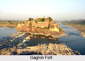
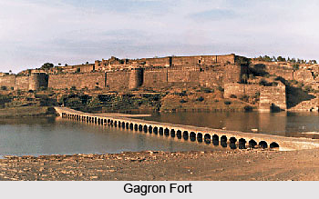
 Gagron Fort is a renowned fort located 12Kms away from Jhalawar. The foundation of this magnificent fort was laid in the 7th century and its construction completed in the 14th century. Outside the fort is the Dargah of Sufi Saint Mittheshah, where a fair is held every year during the month of Moharram. Nearby is the monastery of Saint Pipa Ji, a contemporary of Kabir, the Bhakti Saint. Gagron Fort is perched on a low ridge at the confluence of the Ahu River and the Kali Sindh River. The fort is surrounded by these rivers on three sides. There used to be a moat on the fourth side, thus completing its defenses. Gagron is among the rare forts which are both a van durg and a jal durg - i.e. both forest-protected and water-protected. It is surrounded by forests and has behind it the Mukundarrah range of hills.
Manohar Thana Fort is a well-walled town with a strong fort. The name Manohar Thana literally means `beautiful outpost`. Manohar Thana was a principal seat of Bhil kings who were supplanted by Hada Rajputs of Bundi, and occupied a very important strategic position. The fort commands the meeting place of two rivers, Parvan and Kaalikhad. The fort has been made impregnable with double fortifications. There is an outer wall and battlements, inside which runs another circle of walls and battlements. A good Dak-Bunglow has been recently constructed here in the fort with beautiful vegetation around. Manohar Thana fort is located 90 Kms from Jhalawar.
 The oldest inscription of the area was found at the fort of Gangdhar. The fort is a remarkable construction with some marvellously built temples which are well worth a visit. It is located 140 Kms from Jhalawar.
The Bhawani Natya Shala was constructed in 1921 by Maharaja Bhawani Singh. It is a unique theatre which was built for the performance of plays and other cultural events. It was a popular Parsi theatre earlier. It has been recently revived and gives a very good insight into the theatre. It is quite a unique structure and an architectural marvel. Its uniqueness lies in the fact that its deep stage with its underground construction allows the horses, and even the chariots, to appear on stage. Believed to be one of the eight such theatres in the world, in its heyday it was the venue of great plays ranging from Shakuntalam to Shakespeare`s classics.
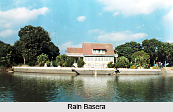
The Ren Basera, on the Jhalawar-Kota Road, just 6 km short of Jhalawar town is a beautiful wooden cottage located on the banks of Kishan Sagar. Maharaja Rajendra Singh brought it to the Jhalawar from an exhibition held in Lucknow. It was originally constructed by the Forest Research Institute of Dehradun.
 Bhimsagar Dam is located 24 Kms from Jhalawar. This dam has been built on the Ujad River near the ruins of the old capital of Khichi Chauhans-`Mau Borda`. One can find ruins of the palaces, temples and mosques, built in both Muslim and Rajput architectural style. The dam is an excellent picnic spot.
Chhapi Dam is located 54 Kms from Jhalawar. It is a place of antiquity streamed with beautifully carved pillars, torans and some erotic figures in the ruins of temples scattered over an area of 2 Kms. It stands on the bank of river Chhapi. Dense green forests with lush foliage add to the natural beauty of the spot.
The Government Museum, established in 1915 and located outside the fort palace, is one of the oldest museums of Rajasthan. It houses rare manuscripts, paintings, coins, and the sculptures and statues of various gods and goddesses are especially noteworthy. Inscriptions from the 5th and 7th century are also seen here. Many idols that have been recovered from ancient ruins are added here. The Ardhnarishvara Natraj, from this museum, was displayed in Moscow, during the Festival of India celebrations.


