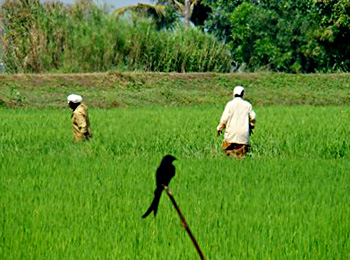
 The economy of Bankura district is characterised by an overwhelming agro-economic base and low urbanisation and industrialisation. The district of Bankura can be broadly divided into two regions- the alluvial plains in the east and the undulating tract to the west. Within the district, and even within these regions, the villages vary not only in their geographical features but also in their physical forms and composition which affects their economic and social patterns. Agricultural activities and employment pattern are determined according to all these patterns.
Mines and minerals play a very important role in the economy of Bankura district. A number of mines and mineral based ventures have already come up on the stretch of land between Bankura to Satora. In areas like Chhatna, Saltora Khatra, Ranibundh, Bankura to Indpur stretch and Raipur and Taldangra, the prospects for setting up of mines and mineral based industries are quite bright, subject to environmental clearance.
The blocks like Bishnupur, Sonamukhi, Patrasayer, Indus, Joypur and Kotulpur have been setting up agriculture based industries like rice and oil mills. There is however scope for more. The climate is also conducive for food processing ventures.
The forest wealth of Khatra and Ranibandh areas has always been remarkable. Various forest produce and medicinal flora and fauna are routinely exported to neighbouring districts and also outside the state.
Cottage and small scale industries constitute a major segment of the district`s economy. It provides maximum employment opportunities next to agriculture and this accounts for nearly 9 percent of the district income. There is ample scope for development in this sector with provision of modern technology and other infrastructure facilities. Effort has been taken up for the improvement of designs, marketing assistance and finance etc. of these industries, specially in case of brass and bell metal craft, conch shell products, fishing hook, pottery and leather products etc. through different development agencies. New technology in Babui Rope Making and Sal leaf product has contributed immensely towards the economic upliftment of the rural people of tribal areas.
As regards the agricultural scenario in the district, climatic condition depending upon rainfall , temperature , humidity and altitude accompanied by various complex features like land form, hydrology and soil combination has greatly influenced the farming system of Bankura District. In Bankura District two Agro Climatic Zones, namely Undulating Red and lataritic in Sonamukhi , Joypur, Bishnupur, Ranibandh, Gangajalghati , Borjora, Saltora, Onda, Taldangra, Simlapal, Mejhia, Raipur, Sarenga, Chhatna, Indpur, Khatra, Hirbandh, Bankura-I and Bankura-II blocks and Vindhyan Alluvial Zone in Patrasayer, Indus, Kotulpur blocks, are found to exist.
The net cultivable area of the district is 4.30 lakh hectares. Among the major crops grown in the district are rice, wheat, oilseeds and vegetables which occupy a major portion of the gross cropped area. Most of the pre-Kharif and Kharif rice are grown in rainfed conditions. Use of HYV seeds in the district farming scene is about 9 percent. It may be noted here that wheat is the second most important cereal crop in the district and it is cultivated in assured/limited irrigated areas. Among oilseeds, rape, mustard and sesamum are the most important. Sesamum is cultivated in 3 seasons while rape and mustard are cultivated during Rabi season. Of the total cropped area, about 46 percent is under irrigation.
Due to continuous division and fragmentation of cultivated land, agriculture is becoming less remunerative. It is paradoxical that though Bankura lies in the sub-humid zone having a total annual rainfall of 1300 mm to 1400 mm yet agriculture is largely dependent on the vagaries of monsoon. Drought constitutes a major hazard in the district. Intermittent gaps in precipitation and moisture stress during the monsoon gives rise to serious setbacks in production during the Kharif season, which is the mainstay of agriculture in the district.
The land use pattern differs in a pronounced manner from west to east with varying soil conditions. The eastern alluvial tract is well cultivated and most of the area is double cropped. Uncultivable wastelands are not usually found in this part, except in the slopes and banks of drainage channels, which are not suitable for cultivation due to sheet and gully erosion. Baid type of land occurs at a lower level than the gullied waste lands and is covered with sandy loam soil on which paddy is grown. Kanali lands are at still lower level lands in the alluvial tract on which paddy is grown extensively with moderate to good yields. Sol or Bahal type of lands with loamy or clay soils and with ample surface moisture is best for cultivation of paddy and summer vegetables. Lands with laterite soil are generally covered by Sal forest except for cultivated patches within them.
The economy of Bankura district is therefore mostly agriculture-dependant.


