 Archaeology of Lower Dibang Valley district could be traced from the pre-historic period. Due to the exploratory research works in this region it is possible to understand the vast history of the Lower Dibang Valley district. The archaeological excavations establish the history of human habitation in this district as well as its adjacent areas in the state of Arunachal Pradesh that started from the pre-historic age.
Some of the prominent archaeological sites are as follows -
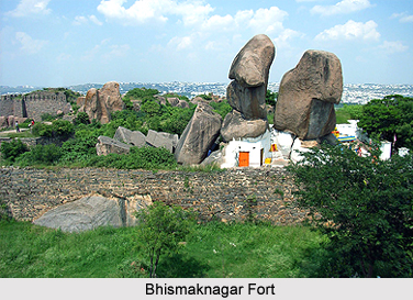
Bhismaknagar fort - This heritage monument is located around 30 km from Roing. It is recorded as the oldest archaeological site in the region. The entire area of the fortress is protected with a rampart wall made of bricks, stone and mud and the northern side of the fort is protected by natural boundary of hills.
Rukmini nati - The ruins of ancient palaces of Princess Rukmini is situated at the heart of Chimiri village, which is located around 12 kms from Roing. One can find the remains of burnt and baked bricks, which indicates the progress of the former civilization. The popular legend associated with the site tells that "Rukmininati" was the Palace of Princess Rukmini, who was the daughter of King Bhismak. Several researches reveal the structure of two rooms, which are made of bricks up to the plinth level.
Ita Pukhuri - It is an ancient pond situated around 14 kms from Roing, Ita Pukhuri, the ancient tank, measuring 57m x 57m is positioned at Ithili village. A large number of bricks have been used in construction of its banks.
Padum Pukhuri - It is another historical brick built pond, measuring 60m x 60m located at Ithili village around 14 kms from Roing. It is situated at a few hundred yards away from Ita Pukhuri (ancient pond in the Lower Dibang Valley district). Interestingly, in the months of October or November, numerous lotus flowers bloom in this pond.
Kampona Pond - This ancient pond is situated at Idili village at a distance of 17 km from Roing. Kampona in the dialect used by Adi tribe means good looking. It is an ancient tank with clear water. Kampona, measuring around 146m x 90m, is the abode of Nag Raja, as per the belief of the people belonging to this tribal group.
Kanying Nat - Kanying Nat is an ancient tank located at Idili village. In Adi dialect "Kanying" literally means ugly looking. This name has been given to the tank because of its peculiar shape as it neither square nor rectangular. Its area is almost 135m x 90m. Bricks have been used for construction of tank.
There are some archaeological remains in the district as for instance the ancient brick well is situated at Devnath village, 5 kms away from Idili village. The perimeter of the well is around 6.3 feet and the depth is nearly 8.45m. The bricks used in it measures around 16 inches x 12 inches and stretched out towards the top with a thickness of 3 inches. Some of the bricks or slabs contain design of birds, bows and arrows with perforations. Moreover, around 12 kms away from Roing a hill fort is extended over Chidu and Chimiri fortresses. The remains of Chidu have been completely destroyed in the earthquake in the region of 1950. The brick structures of the room measuring 10m x 10m and 10m x 12m up to the plinth level is still intact.
Near about 19 kms from Roing at Injonu village, a stone image of Lord Ganesha was un-earthed. It was formed of granite rock, measuring 44 inches high and 27.5 inches wide. During researches, it has been found that of the four arms, the lower right is broken from wrist and other three arms are depicted with weapons like hand axe, conch etc. The mahout of Lord Ganesha, the rat is also depicted at the bottom right of the image. There is a spiral line of decoration all along the border. From the stylistic aspect, the antiquity of this stone image could be placed in the 9th or 10th century A.D. thus, these are some of archaeological remains of the Lower Dibang Valley district.


