Introduction
Vizianagaram District is one of the northern coastal district of Andhra Pradesh, India. Vizianagaram city is the district head quarter. This district was formed on 1 June 1979, with some parts carved from the neighbouring districts of Vishakhapatnam and Srikakulam. In Telugu Vizia means Victory and Nagaram means city. The district was named after the princely state of Vizianagaram.
History Of Vizianagaram District
The history of Vizianagaram district is closely connected with to that of Kalinga, one of the political divisions of ancient India. Only in modern times, the upper part of Kalinga was gradually merged into Orissa State and the lower part into Andhra Region.
In tracing the history of the region, one of the most important events that emerge is the war between the Rajahs of Vizianagaram and Bobbili, popularly known as the Bobbili Yuddham. The war was fought between the Rajah of Vizianagaram who was aided by the French General Bussy and the Rajah of Bobbili on the 24th of January, 1757. The bravery and valour of the soldiers of Bobbili displayed in this war is still remembered by the people of the area. Yet another important episode in the history of the district is the war between the French and the English. This battle was fought at Chandurthi in 1758. The French were defeated in this war and consequently the Northern Circars were handed over to the British under a firman from the Emperor Shah Alam of the Mughal dynasty in 1765 which were placed under the then existing Chief and Council at Vizagapatam. In 1794, the Chiefs and Councils were abolished and Vizagapatam was arranged into three divisions each under a Collector. Almost the entire area of the present area of Vizianagaram district fell under the second division.
The history of the rebellions against foreign rule goes back to 1830s when the people of the district particularly the tribals, unable to beat the oppression, rose in frequent rebellions (fituris) leading to the establishment of separate administrative system known as "Agency Administration" under the India Act XXIV of 1839. The rebellion of Korra Malliah, a tribal chief of the Salur area against the British rule in 1900 is another important event in the struggle against the foreign rule. The District Magistrate dispatched Reserve Police to suppress the revolt which was seriously resisted by the people. In the skirmish that followed many were killed. Korra Malliah along with his son was arrested and kept in imprisonment where he died subsequently. In the freedom struggle the people hailing from the area enthusiastically took part in various phases of the movement like a Non-cooperation movement, Civil Disobedience movement, Quit India Movement etc.
After abolition of the Zamindari system in1948, Visakhapatnam district was found to be unwieldy for administrative purposes. Consequently, Srikakulam district was carved out in 1950, bifurcating it from Visakhapatnam district. The constitution of Vizianagaram district in 1979, by transferring the taluks of Parvathipuram, Kurupam, Salur, Bobbili, Badangi and Cheepurupalle from Srikakulam district and some taluks of Visakhapatnam forms the latest development in the history of the district.
Princely State of Vizianagaram
The Princely State of Vizianagaram was a native state under the indirect control of the British administration which was supervised by the Indian prince. During the medieval period, the region was conquered by several Hindu Emperors of Kalinga. After the decline of the federal Gajapati Empire of Orissa, the state was governed by the Golkonda (Golconda) emperors. The Pusapati family was the ruling family of the princely state. The ancestors of Maharajas of Vizianagaram state descended from the Ranas of Udaipur (Rajasthan), the Sisodia dynasty of the Guhilot tribe and Vasishta gotra. Amala Raju constructed the village Pooshpadu in Nandigama Taluq, which later became renowned as Pusapadu. Eventually the Kshatriyas who settled in the area came to be identified as Pusapati. The Pericchedis, the earliest ruling family of Andhra Pradesh, were the ancestors of the Pusapatis.
The dynasty of the Pericchedis were generally supporters of Hindu Dharma, where as the Chalukyas were patrons of Jainism initially. After the family moved to the coastal region, the name of the family was altered to Pusapati. The name highlighted their Suryavanshi ancestry, as the name was derived from the Sanskrit term Pushavat, which means the Sun. The family established the territory of Vizianagaram, which was dedicated to Vijay Rama Raju. In the 16th century, the native rulers of the state acquired the title of Gajapathi, after the battle of Nandapur in the Northern Circars.
The fort of Vizianagaram was founded during the year 1712- 1714 AD. Initially there were 5 signs of victory, known as Vijayas, which existed at the time of inception of the Vizianagaram fortress. It was named after its Vijaya Rama Raju, who laid the foundations on the 10th day of the Dussehra Festival in the year Vijaya. Later in the year 1754, Pusapati Vijaya Rama Gajapathi Raju of the ruling family of Vizianagaram made an agreement with the French; but later the state was ceded to the British East India Company. The territory remained under the suzerainty of the British administration until the Indian independence in 1947.
The British Government of India bestowed various honours on Maharaja Vijay Rama Gajapati Raju III in the year 1827. He was also conferred the title and style of His Highness by Lord Northbrook, who also enrolled among the native chiefs entitled to return visits from the Viceroy. The state was honoured as one of the Salute States of India with a gun salute of 13 guns.
After the withdrawal of the British administration, the princely state of Vizianagaram was acceded to the newly formed Dominion of India, also known as the Union of India.
Geography Of Vizianagaram District
 Vizianagaram district is located in the state of Andhra Pradesh. It is situated within the geographical co-ordinates of 17 degrees 15 min and 19 degrees 15 min of the Northern latitude, and 83 degrees 00 min and 83 degrees 45 min of the Eastern longitude. The District is bounded on the East by Srikakulam District on the West and South by Visakhapatnam District, on the South-East by the Bay of Bengal and North West by Orissa State.
Vizianagaram district extends over an area of 6,539 Sq. Kms with a density of 343 per Sq. Km covering 1,551 villages, out of which 66 are uninhabited. The areas transferred from Visakhapatnam district are mostly picturesque especially in the north. The agency track mostly consists of the hilly regions covered by the Eastern Ghats mountain range which run parallel to the coast from the North-East to the South-West. The average height of these hills is over 914 metres, although there are several peaks of even 1,219 metres high. The principal rivers flowing in the district are Nagavali, Vegavathi, Gomukhi, Suvarnamukhi, Champavathi and Gostani. The Nagavali is the main river, which flows in about 112 Km in Vizianagaram district covering an ayacut of 2,832 Hectares. The river Gosthani has its origin in Anantagiri forest area and flows through S.Kota and Jami mandals. The Suvarnamukhi River takes its birth in the hills of Saluru mandal and takes an eastern direction and finally joins the Nagavali at Sangam village in Palakonda mandal of Srikakulam District. Vegavathi originates in pachipenta hills of Pachipenta Mandal and flows almost parallel to Suvarnamukhi covering an ayacut of 2,428 Hectares.
 The climate of Vizianagaram district is characterised by a very high level of humidity nearly all the year round with oppressive summer and good seasonal rainfall. The summer season is from March to May. This is followed by the South-West monsoon season, which continues up to September. October and November constitute the post monsoon or retreating monsoon season. December to February is the season of generally fine weather. The climate of the hill parts of the district is different from that of the plain.
The normal rainfall of the district for the year is 1,131.0 mm. The district gets the benefit of both the South-West and North-East monsoon.
The flora found in the forests of the district is of much interest. The forest types found in the district are Southern tropical moist mixed deciduous forests, Northern tropical dry deciduous forests, Southern tropical dry mixed deciduous forests, Dry deciduous green forests and Dry Evergreen forests. Forestry plays an important role in the economy of the district. Fauna in the district is fairly high in the interior hill regions, but it is heavily threatened with extinction. The reasons for the depletion are mainly shrinkage of habitant and uncontrolled poaching. The principal animals and birds found from the seacoast to high plateau are yellow bat, Sloth bear, Wild buffaloes, Fox, Hare, Hyena, Jackal, Mongoose and birds like the Blue rock pigeon, House crow, House sparrow, Common myna Pitta etc. Consequent to the enactment of the wild life protection act of 1972, it is hoped that wild life would improve and attain the past glory.
The main soils in the district are red soils, sandy loams and sandy clay and they constitute 96 percent of the total area. The soils in the district are predominantly loamy with medium fertility. There are mostly red loamy soils, as far as dry lands are concerned and clay loamy in case of wet lands.
There a number of medium irrigation projects, irrigating an area of about 43, 984 hectares in the district. These are the Thatipudi reservoir, Vegavathi Project, Vattigedda Project, Nagavali right and left side channels, Pedankalam Anicut, Seethanagaram Anicut, Denkada Anicut, Paradhi Anicut, Surapadu Anicut, Vengalarayasagar Project, Andra project.
Economy Vizianagaram District
Vizianagaram is prominently an agricultural district as 68.4% of the workers engaged in agriculture. Generally 82% of the population lives in rural areas and depends on agriculture only. 80% of the cultivation is done under rain fed conditions. Even the irrigated area is also depends on the rainfall. Hence the majority of the crops grown are dried crops. Paddy crop is cultivated mainly during Kharif season with 80% of the area under tanks, which in turn depends on rainfall. The major crops are grown are Paddy, Mesta, Groundnut, Ragi, Bajra, Cotton, Sugarcane and Pulses.
There are no major irrigation projects in the district. Because irregation projects are also depends on raining. Only 12 medium irrigation projects are working with 43,984 hectors of land and other minor 1,065 irrigation sources have 51,215 hectors, and 8,616 minor irrigation Tanks with 72,112 hectors of land.
The industrial development in this district are generally agriculture based and consists of Jute mills, Sugar factories, Rice and oil mills and Tiles manufacturing units. The minerals deposited are utilized by the FACOR (The Ferro Alloys Corporation Limited) and other industries. There are 520 factories registered under the factory act in 2005 in the district employment about 27,800 workers.
Nationalized banks, Private and cooperative banks are operating in the district from 148 branches. State Bank Of India with 29mbrances and Andhra bank with 14 branches are leading in the state. S.V. Grameena bank with 56 branches, and Vizianagaram district cooperative Central banks are the leading cooperative banks in thr Vizianagaram district.
Divisions of Vizianagaram District
There are 12 assembly and two parliamentary constituencies in Vizianagaram district. The parliamentary constituencies are Bobilli and Parvathipuram. The assembly constituencies are Bhogapuram, Bobbili, Cheepurupalli, Gajapathinagaram, Naguru, Parvathipuram, Salur, Sathivada, Shrungavarapukota, Therlam, Uttarapalli, and Vizianagaram.
There are two Revenue divisions,34 Mandals, 935 Panchayat, 1,551 revenue villages in Vizianagaram.
Demography of Vizianagaram District
As per 2001 Census, the population of Vizianagaram is 22,49,254. they consists of 11,19,541 males and 11,29,713 females. There are 1009 females per 1000 males in the district.
Culture Of Vizianagaram District
Culture of Vizianagaram district is one of a land, inhabited by high spirited rajahs, passionate poets and writers. The culture of any place is contained in its people and the traditions that they pass down to the future generations. So also, Vizianagaram boasts of a number of famous personalities who have preserved, added to and carried forward the rich cultural heritage of the place.
 Many eminent personalities have added new dimensions of glory to Vizianagaram district. The Pusapatis of Vizianagaram, the Ravus of Bobbili, Varicharlas of Kurupam, the Satrucharlas of Merangi and the aristocrats of Salur were all exalted luminaries and multi-faceted personalities. Their patronage of Art and Literature is highly laudable. They had loved and invited the democratic spirit much before the abolition of princely state by the Government Act 1948. The battle of Bobbili and the battle of Padmanabham are unforgettable and make the area the land of pride and valour.
500 Years of glorious past and rich cultural heritage made Vizianagaram the cultural capital of Andhra Pradesh. It acquired a separate statehood in 1979. Raja Saheb Dr. P.V.G. Raju renounced his Zamindari with out taking any compensation and their fort has now entirely became the citadel of education which houses one of the oldest colleges (Maharaja College, 1879) in India. The social reformer, Sri Gurajada; the poet singer, Sri Adibhatla Narayana Das; the great wrestler Kodi Rama Murthy; the imaginative poet, Sri Devulapalli Krishna Sastry were associated with the college in some form. The talented musicians Dwaram Vekata Swami Naidu, Saluri Rajeswara Rao and late R.P. Pattanayak hail from this place. The divine singers Gantasala and Suseela who were the proud students of Maharaja College of Music added indescribable grace to the art of singing.
One of the oldest musical instruments known in India, with a mention of it in almost all ancient texts, the Saraswatihi Veena, is an integral part of Carnatic music, winning the hearts and earning the applause of the music lovers the world over. Over three centuries, a unique style of playing the Veena has developed in Bobbili, called the "Bobbili veena sampradayam".Its exponents have performed to much acclaim from Indian and International audiences. This achievement was matched with a rise in the fine and intricate art of Veena making. The Saraswathi Veenas of Bobbili are unique in depth and fullness of tone and are remarkable for their exquisite designs and patterns.
Every year on the first Tuesday passing Vijayadasami, the Sirimanu Utsav is celebrated. Sirimanu means a big tree. It is known that before 15 days of Sirimanu Utsav, the goddess Pydimamba will come in the dream of a temple Pujari and tell him where the Sirimanu for this year is located. The Pujari will then go in search of Sirimanu and will cut the sirimanu while performing puja etc. The owner must agree to cut his tree for the Utsav. That tree will be shaped neatly in to Sirimanu and will be placed over the chariot. At the temple, the Pujari will make darshan of the Goddess and will sit on the Sirimanu chariot. This sirimanu will move 3 times to the Vizianagaram fort and the temple between 3 PM to 4 PM. The Vizianagaram rajahs will sit on the top of the fort and watch the Utsav. Pujari will be given new clothes by the Rajas and the puja will be performed. In front of Srimanu there will be a chariot in the shape of a White elephant. The sirimanu utsav closes exactly before sunset. People come not just from Andhra Pradesh, but also from Orissa and Madhya Pradesh to see the Utsav. Many people pay darshan to the Sirimanu. Farmers take a small part of the branch and keep it near their plough in order to have a good crop in the coming year.
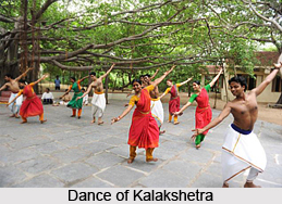
The Vizianagaram Utsav focuses on the rich culture of this area in all its facets with a view to infuse a sense of pride in the past and a determination to combine tradition with modernity in the youth of the day. The main ambition of this Utsav is to recall the good in the past and avow to preserve for posterity and improve it whenever necessary for the future to emulate .A series of programmes like Aradhana and Kavita Ghosti at Gurujada House, Games and Sports at Vizzy stadium, Folk Forms at Bankuladiba, Mythological and Social Dramas at Gurujada Kalakshetra, Art Exhibition at TTD Kalyana Mandapam, Photo exhibition at Lions Community Hall, Science exhibition at M.R.Model High School, Music and Dance Concerts at Ananda Gajapathi Auditorium and Flower Show, Industrial exhibition and Musical Performances at "Ayodhya Maidanam" are conducted during the three day celebrations.
Many eminent personalities have added new dimensions of glory to Vizianagaram district. The Pusapatis of Vizianagaram, the Ravus of Bobbili, Varicharlas of Kurupam, the Satrucharlas of Merangi and the aristocrats of Salur were all exalted luminaries and multi-faceted personalities. Their patronage of Art and Literature is highly laudable. They had loved and invited the democratic spirit much before the abolition of princely state by the Government Act 1948. The battle of Bobbili and the battle of Padmanabham are unforgettable and make the area the land of pride and valour.
500 Years of glorious past and rich cultural heritage made Vizianagaram the cultural capital of Andhra Pradesh. It acquired a separate statehood in 1979. Raja Saheb Dr. P.V.G. Raju renounced his Zamindari with out taking any compensation and their fort has now entirely became the citadel of education which houses one of the oldest colleges (Maharaja College, 1879) in India. The social reformer, Sri Gurajada; the poet singer, Sri Adibhatla Narayana Das; the great wrestler Kodi Rama Murthy; the imaginative poet, Sri Devulapalli Krishna Sastry were associated with the college in some form. The talented musicians Dwaram Vekata Swami Naidu, Saluri Rajeswara Rao and late R.P. Pattanayak hail from this place. The divine singers Gantasala and Suseela who were the proud students of Maharaja College of Music added indescribable grace to the art of singing.
One of the oldest musical instruments known in India, with a mention of it in almost all ancient texts, the Saraswatihi Veena, is an integral part of Carnatic music, winning the hearts and earning the applause of the music lovers the world over. Over three centuries, a unique style of playing the Veena has developed in Bobbili, called the "Bobbili veena sampradayam".Its exponents have performed to much acclaim from Indian and International audiences. This achievement was matched with a rise in the fine and intricate art of Veena making. The Saraswathi Veenas of Bobbili are unique in depth and fullness of tone and are remarkable for their exquisite designs and patterns.
Every year on the first Tuesday passing Vijayadasami, the Sirimanu Utsav is celebrated. Sirimanu means a big tree. It is known that before 15 days of Sirimanu Utsav, the goddess Pydimamba will come in the dream of a temple Pujari and tell him where the Sirimanu for this year is located. The Pujari will then go in search of Sirimanu and will cut the sirimanu while performing puja etc. The owner must agree to cut his tree for the Utsav. That tree will be shaped neatly in to Sirimanu and will be placed over the chariot. At the temple, the Pujari will make darshan of the Goddess and will sit on the Sirimanu chariot. This sirimanu will move 3 times to the Vizianagaram fort and the temple between 3 PM to 4 PM. The Vizianagaram rajahs will sit on the top of the fort and watch the Utsav. Pujari will be given new clothes by the Rajas and the puja will be performed. In front of Srimanu there will be a chariot in the shape of a White elephant. The sirimanu utsav closes exactly before sunset. People come not just from Andhra Pradesh, but also from Orissa and Madhya Pradesh to see the Utsav. Many people pay darshan to the Sirimanu. Farmers take a small part of the branch and keep it near their plough in order to have a good crop in the coming year.
The Vizianagaram Utsav focuses on the rich culture of this area in all its facets with a view to infuse a sense of pride in the past and a determination to combine tradition with modernity in the youth of the day. The main ambition of this Utsav is to recall the good in the past and avow to preserve for posterity and improve it whenever necessary for the future to emulate .A series of programmes like Aradhana and Kavita Ghosti at Gurujada House, Games and Sports at Vizzy stadium, Folk Forms at Bankuladiba, Mythological and Social Dramas at Gurujada Kalakshetra, Art Exhibition at TTD Kalyana Mandapam, Photo exhibition at Lions Community Hall, Science exhibition at M.R.Model High School, Music and Dance Concerts at Ananda Gajapathi Auditorium and Flower Show, Industrial exhibition and Musical Performances at "Ayodhya Maidanam" are conducted during the three day celebrations.
Tourism In Vizianagaram District
 Tourism in Vizianagaram district comprises visits to a number of beautiful temples located here. Apart from these places of historical importance are also found here, such as the Vizianagaram and Bobbili fort.
Pilgrimage Tourism
Paiditalli Ammavari Kovela temple is very famous in Vizianagaram. The Vizianagaram town is full of forts and the Ghantastambham (the clock tower) is also a popular place.
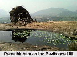
Ramathirtham is famous for the 1000 years old Sri Rama temple situated on the Bavikonda hill. It was constructed by the Pusapati Kings during 1650-1696 A.D. Located close to the beautiful Koneru Lake, the unique feature of this temple is that it is built entirely on a single piece of rock. Nearby on a hill, known as Gurubukhatakonda are found the remains of an enormous Buddhist mahasthupa, which is 19 feet high and 65 feet in diameter, a monastery, chaitya, monastic cells, two votive stupas, a solid stone stupa, an enclosed courtyard and a pillared hall. In the vicinity are the ruins of a brick shrine with images of Jain Thirtankaras. Further up on the hill under a massive hanging rock one can see several Jain sculptures. The temple complex is located 13 kms from Vizianagaram. Accommodation is available at R and B Guest House, Vizianagaram.
The Jami tree at the Tripurtantaka Swamy temple is considered to be holy for its miraculous properties. It is located in Jammi on the banks of the river Gowthami, 10 Kms from Vizianagaram the temple is said to be thousands of years old. Folklore says that the local inhabitants tried to shift the temple but they could not uproot the sivalinga. Legend has it that the Pandavas hid their weapons on a "Jami Tree" before embarking on the final year of their exile (Agnathavasam). During their stay, King Dharmaraj and Kunthi installed the idols of Sri Thirupuranatha Swamy and Sri Janardhan Swamy, at this place. 500 years ago villagers found an idol of Sri Madhava Swamy and established it between the earlier two temples and named it Sri Venugopalaswamy Temple. Modern day geologists estimate that the Shivalinga extends more than 179 feet deep in to the earth.
 One of the oldest Shiva temples is situated at Punyagiri, 25 kms away from Vizianagaram. The sanctum has an underground water source which ensures that the Shivalinga is perpetually bathed with water. In the nearby Trimurthi cave, three lingas are installed over which water constantly drops. Considered to be a very holy spot, a large numbers of devotees flock here during the Mahashivratri festival. Legend has it that if one bathes in the waterfall nearby and then has Darshan of Lord Shiva, he attains Moksha.
The small village of Kumili, 20 kms from Vizianagaram, is famous for a huge complex of temples built by local devotees over a period of ten years. The temples are unique with extremely attractive sculptures, paintings on the walls and idols. The temples within the complex are of Ganapathi, Shiva, Kalika Devi, Navagrahalu, Satyanarayana Swamy, Subramanyeswaraswamy, Seetharamaswamy, Anjaneya Swamy and Venu Gopalaswamy. Incidentally, the village was the former seat of the erstwhile Vizianagaram Kingdom and ruins of a mud fort still exist.
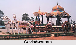 Govindapuram is situated in Pusapatirega Mandal, at a distance of 30 kms from Vizianagaram town. The magnificent temple here is renowned for its sculptural beauty and is based on the essence of the Bhagwad Gita. Gyana Ratham with Lord Krishna on the chariot is an impressive image which enthralls the visitors.
The Moddukovillu temple is unique in that the Shivalinga in the temple has two different colours, symbolizing the male and female aspects of the union of Lord Shiva and Goddess Parvati. The temple was built by an old woman who dreamt about it on her way to the holy city of Kashi (Varanasi).
Saripalli is famous for Dibbi Lingeswara Swami temple, which is over 1000 years old. The Chanukyas constructed this temple. The sculpture carved on the temple is beautiful.
Leisure Tourism
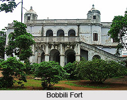
 The Bobbili fort is situated in the ancient town of Bobbili located 60 kms away from Vizianagaram. It is associated with the historic battle between the Raja of Bobbili and Zamindar of Vizianagaram, who was aided by the French. The fierce war established this as a land of heroism, bravery and courage. The impressive Bobbili fort stands as a silent testimony to this hard fought battle, which saw the Raja of Bobbili lay down his life fighting rather than surrendering. The Venugopala Swamy temple here is quite famous as also the oldest in the district.
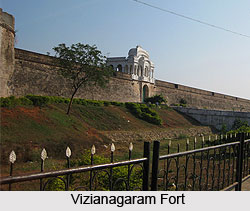
The imposing Vizianagaram fort formed the nucleus around which grew the town of Vizianagaram. The quadrangular stone fort is evident of the knowledge and skill of the builders and architects of those days. Also located in this town is the ancient temple of Pydithalli Ammavaru. Legend has it that one of the daughters of the Pasupati royal family was the reincarnation of the pressing deity, Pydithallamma. The locals believe that with the blessings of the Goddess one can lead a happy and prosperous life. The idol of the Goddess was discovered on Vijayadasimi day way back in the year 1752. To mark the occasion, an annual jatra is held on 21st and 22nd October which attracts large crowds.
Gosthani Sarovar Vihar is situated at Thatipudi reservoir at a distance of 20 Kms from Vizianagaram town. It is a picnic spot.
Flora and Fauna of Vizianagaram District
Forest plays an important role in the economy of Vizianagaram. The types of forests are found here are-1. Southern tropical forests 2. Northern Tropical Dry Forests. 3.Southern Tropical Dry Forests. 4.Dry Deciduous Green Forests. 5. Evergreen Forests.
The principal animals here are Yellow bat, Sloth bear, Wild Buffaloes, Fox, Hare, Hyena, Jackal, Mangoos.
The principal animals here are Yellow bat, Sloth bear, Wild Buffaloes, Fox, Hare, Hyena, Jackal, Mangoos.
Education in Vizianagaram District
Vizianagaram is comparatively backward in the field of Education. The literacy rate is 51.82% as against the average of 61.55% for the entire Andhra State.
There are 2379 Primary schools, 452 Primary schools and 341 High Schools in 2004-2005. there are 81 Junior and 33 Degree Collages. There are 14 Industrial Training Institutes and two Polytechnic Colleges. There are nine B.Ed Colleges and one M.Ed College. One Sanskrit College and Music and Dance College is also present here. There is a Postgraduate Center, five Engineering Colleges, two Law Colleges and a Medical College in Vizianagaram district..
There are 38 branch libraries in the district managed by Zilla Granthalaya Samstha. There are also 41 book depot centers in the district.
Transport
By Air
Vishakhapatnam is the nearest airport to reach Vizianagaram.
By Rail
Railway network in the entire district comes under Waltair division of the East Coast Railway, Indian Railways. Vizianagaram and Kothavalasa are the main railway junctions. There are also 28 railway stations in the entire district.
By Road
National Highway 5 and 43 runs almost entirely in Vizianagaram district. Andhra Pradesh State Road Transport Corporation (APSRTC) is the major transport system operated by fleet of buses. There are four bus depots at Vizianagaram, Parvathipuram, Srugavarapukota and Salur.


