Introduction
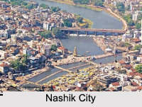 Nashik is the beautifully laid city in Nashik District of the western Indian states- Maharashtra. This city of west India is developed near Godavari River.
Location of Nashik
Nashik is located about 180 kilometers from capital city of Maharashtra, Mumbai. It is about 220 km from Pune which is located in Pune District.
History of Nashik
 History of Nashik traces back to the early Stone Age, when a nucleus of settlement was made near the River Gangavadi. Presently, Nashik is a district head quarters located on the banks of Godavari and is 185 km away from Mumbai. The climate of this city is moderate, and is located at 635 m above mean sea level. The city has developed on both the banks of Godavari, which divides the city into almost equal halves.
The history of Nashik dates back to Ramayana and there are many references of the city in many epics as well as Vedas, however, today the city has developed into a metropolis with a population of 14 lakh souls. The city since its ancient days has developed on the banks of Ganga with religious significance. Today, Nashik is also a flourishing Industrial Centre as well as an educational center.
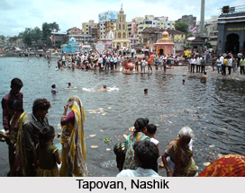
The ancient history of Nashik can be derived from archaeological excavations and it is found that the territory around Nashik was occupied in the early Stone Age. Tools of trap rock characteristic of that time were found buried in the riverbed at Gangavadi, 16 Km North - West of Nashik. Agastya, the renowned sage was the first amongst the Aryan clan to cross the Vindhya Mountains and live on the banks of the Godavari. Other sages followed Agastya and the group of hermitages of the bank of the Godavari was called "Janasthana". Lord Ram along with his younger brother Lakshman and wife Sita met Agastya, and he gifted Ram with bow and two quivers presumable to fight the rakshasas. He also advised him to settle down at Panchavati, so called because of the five great banyan trees, which grew there. Panchavati was then at the outskirts of the Dandakaranya forest. It is from here that Ravan of Lanka seized Sita. Later on poets like Valmiki, Kalidas, the dramatist bhavbhuti did much research and found in "Padmapur" as Nashik was then known, great inspiration.
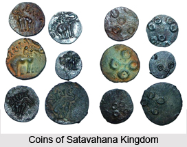 In the medieval history of Nashik, all this territory was included in Ashok`s mighty empire. Later during the era of the Satavahana kingdom the Nashik district became very prosperous as it was based on the trade route to Broach. The city was named as "Gulshanabad" during Mughal period, in admiration of beauty of Nashik. The old name was reinstated when Peshwas took over in 1751. Raghobadada and Anandibai of Peshwas stayed at Nashik during later part of their life. By 1818, Nashik was considered as a town with two palaces, magnificent buildings and beautiful gardens and vineyards
On April 19,1818 Nashik was annexed by the British. During the freedom struggle of 1857, Nashik was the spot of considerable disturbance. The struggle subsided by 1860, and Nashik once again retained peace. Nashik Municipality was formed in 1864. In 1869, Nashik was made a District with its present 13 talukas. Railway tracks were laid and Nashik Road railway station was also formed. Nashik Road subsequently grew with the establishment of India Security Press, Central Jail, and the Distillery, which then existed for the English soldiers at Deolali. Nashik eventually became a flourishing commercial centre where artisans were skilled in making utensils and smiths excelled in making silver and gold ornaments.
Nashik was always prominent as a center of revolutionary activities; Anant Kanhere, a great revolutionist, fired at Mr.Jackson, the then Collector of Nashik on the night of 21st December 1909, while he was watching a play at Vijayanand Theatre. Mr Jackson died on the spot, which resulted in arrests, trails and sentences. Mahatma Gandhi`s non-cooperation movement found its strong platform of forest satyagrahas and underground activities here in Nashik as well. Dr. Ambedkar later organized his temple entry movement for the abolition of untouchability and mass Satyagraha was organized in 1932. In 1950, Session of India National Congress was also held at Nashik at a place now called Nehrunagar (between Nashik and Nashik Road). The history of Nashik is not only interesting but inspiring enough to depict how a primitive civilization has grown to a metropolitan city with gradual success.
Geography of Nashik
This "Wine Capital of India" is situated geographically on the western edge of the Deccan Plateau.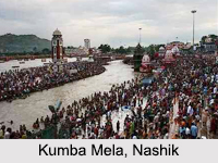 It is an integral part of Western Ghats Mountain Range in India. Nashik in Nashik District is located at about 700 m at sea level. Godavari River originated from the Brahmagiri Mountain and it is the life line of Nashik.
Nashik Division
 In the state of Maharashtra of India one can easily locate the presence of Nashik Division. It is one of 6 divisions of Maharashtra state. Khandesh region encompasses northern part of the division. Other divisions form boundaries of this Nashik division. On the western part Konkan Division and Gujarat state are found, Madhya Pradesh lies to the northern portion . Amravati Division and Marathwada (Aurangabad Division) are located in the eastern side. Pune Division forms the southern boundary.
Experts have further incorporated few more information about Nashik Division. It covers a total area of 57,268 sq. km. Four administrative district of Nashik Division are Ahmednagar, Dhule, Jaigaon, Nandurbar.
The Census report of the year 2001 acts as vital document, which throws light on certain demographical aspects like literacy rate, population status. As per this repot the total population of Nashik Division has been enumerated to be 15,774,064.
Literacy is yardstick for gauging the growth and prosperity of a particular place. So far as Nashik Division is concerned, the literacy rate of Nashik Division constitutes 71.02 %. Thus it confirms the fact that development has occurred here.
Just like many other regions of Indian continent, in Nashik Division also agriculture is widely practiced by quite a number of people. Principal crops include onion, grape, sugarcane, jowar, cotton, banana, chillies, wheat, rice, nagli, and pomegranate. Irrigation is done in an area of nearly 8,060 sq. km.
Districts of Nashik Division
 Districts of Nashik Division in Maharashtra include the districts like Dhule district, Jalgaon District, Nandurbar District and Ahmednagar district.
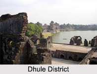
Dhule District
Dhule district is one agricultural district of Maharashtra. The city of Dhule is the administrative headquarters of the district. The Dhule district previously comprised tracts of land predominantly inhabited by tribal population. Dhule district was then bifurcated on 1st July 1998 into two separate districts now known as Dhule and Nandurbar, the latter comprising the tribal region. The agriculture remains the basic profession of the population in Dhule district.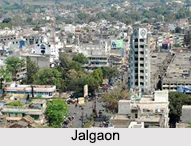 Most parts of Dhule district are not under irrigation and thus cultivation heavily depends on regular monsoon or rain water. Apart from wheat, bajra, jowar or jwari, onion the most favored commercial crop is cotton.
Jalgaon District
Jalgaon District is a district of Maharashtra. It was known as East Khandesh until 21st October 1960. Its capital is the city of Jalgaon. Jalgaon District is bounded by the state of Madhya Pradesh to the north and by the districts of Buldhana to the east, Jalna District to the southeast, Aurangabad District to the south, Nashik District to the southwest, and Dhule District to the west.
Nandurbar District
 Nandurbar District is an administrative district in the northwest corner of Khandesh Region of Maharashtra. On 1st July 1998 Dhule was bifurcated as two separate districts now known as Dhule and Nandurbar. Nandurbar district is bounded to the south and south-east by Dhule district, to the west and north is the state of Gujarat, to the north and north-east is the state of Madhya Pradesh. The northern boundary of the district is defined by the Narmada river.
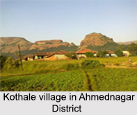
Ahmednagar District
Ahmednagar district is the largest district of Maharashtra. The historical Ahmednagar city is the headquarters of the district. Ahmednagar was the seat of the Ahmednagar Sultanate of late medieval period. This district is known for the towns of Shirdi associated with Sai Baba and Meherabad associated with Meher Baba. Ahmednagar district is part of Nashik Division. Ahmednagar District was created after the defeat of the Maratha Confederacy in the Third Anglo-Maratha War in 1818 AD, when most of the Peshwa`s domains were annexed to British East India Company. The district remained part of the Central division of Bombay Presidency until India`s independence in 1947, when it became part of Bombay and in 1960 the new state of Maharashtra.
Climate of Nashik
Nashik enjoys tropical wet and dry climate. The maximum temperature ranges from 40 degree Celsius to 45 degree Celsius in summer and the winters ranges from 10 degree Celsius to 20 degree Celsius.
Demography of Nashik
According to the Population census in the year 2011, Nashik had a total population of 13, 86,973. The males constitute 7, 84,995 and females constitute 6, 01,978. Nashik had an average literacy rate of 86.96 percent. The male literacy rate of Nashik was 94.96 percent. The female literacy rate was 86.51 percent.
Administration of Nashik
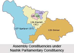
Nashik is a district headquarters of both Nashik District and also Nashik Division. Nashik Municipal Corporation is responsible for the development of this city.
Economy of Nashik
 Nashik is dependent on the tourism, textile, cement industries, wine and iron and steel industries. Nashik is also enriched in agriculture.
Culture of Nashik
As it is located in Maharashtra, Nashik follows Maharashtrian culture and cuisines. Nashik also allures for the presence of Kumbha Mela.
Tourism in Nashik
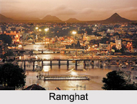
Nashik has many tourism destinations like Panchavati, Ramkund, Muktidham Temple, Kalaram temple, Sundarnarayan temple, Trimbakeshwar, Dugarwadi waterfall, Kapaleshwar temple, ISKCON temple, Coin Museum, Veer Savarkar Smarak, Nandur Madhmeshwar Bird Sanctuary, Pragati Aerospace Museum, Dadasaheb Phalke Smarak, Ramsej Fort, Tringalwadi Fort and Harihar Fort.


