Marandahalli is a ` panchayat town` located on the fringes of Dharmapuri in Dharmapuri district of the southern state of India, Tamil Nadu. Geographically, the town is located between 12.4° North latitude and 78.0° East longitude at an altitude of 581 metres (1906 feet) above mean sea level. The town is well connected to the other cities and towns in the district. While the nearest railway station is the Marandahalli Railway Station, the nearest airport is at Bangalore. It is also accessible from Morappur by road as well as from the Morappur Railway Station and Dharmapuri Railway Station. Spread over an area of two square kilometers, Bangalore is located at a distance of 80 km. from Marandahalli. The nearby towns are Panchapalli at a distance of 12 kms, Palacode at a distance of 14 kms and Rayakottai also at a distance of 14 kms.
 The Indian Census report of 2001 provides detail information about the town. According to the report, Marandahalli had a population of 10,171. Males and females account for an equal proportion of the population. In Marandahalli, 12% of the population is less than six years of age. The average literacy rate of Marandahalli is 61%, which is higher than the national average literacy rate, which is 59.5%. To be specific, the male literacy rate is 66% and the female literacy rate is 55%.
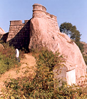
The major occupation of the people living here is farming. Chief crops cultivated here are paddy, tomato, and sugarcane. Coconut and banana trees cover Marandahalli and groundnuts are also cultivated here. The Sanakumara Nadhi passes through this town and joins the River Cauvery in Hogenakkal. Some prime attractions in and around Marandahalli are Hosur, Thally, Government Museum, Rayakottah Fort Krishnagiri Fort, Kelavarapalli Dam, Tillany Fine Arts Museum and Gallery, Krishnagiri Dam, and Hogenakkal Waterfalls.


