 Tourism in Bharatpur is known popularly as `The Eastern Gateway to Rajasthan`. The place was named "Bharatpur" after the name of Bharat, the brother of Lord Rama. His other brother Laxman is worshipped as the family deity of Bharatpur. This place is popular for Brij Festival, Jaswant Exhibition, Gangaur Festival and the colourful festival of Teej. This city is located in the Brij region, Bharatpur was once considered to be an impregnable city and was the capital of the Jat kingdom. The city is situated 180 km south from India`s capital-Delhi, 55 km west of the city Agra and 35 km from Mathura.
Maharaja Suraj Mal founded Bharatpur in 1733 AD. It was an impregnable well fortified city that was carved out of the region known as Mewat. The trio of Bharatpur, Deeg and Dholpur has played an important part in the history of Rajasthan.
It is believed that the place got its name after the name of Bharat, who is brother of Lord Rama. Legends say that Laxman`s name is engraved on the state arms and the seals of Bharatpur.
Bharatpur District with the fort has been founded Rustam, a Jat of Sogariya clan. It is said that Maharaja Suraj Mal took over the empire from Khemkaran, the son of Rustam and established his empire. He builds a massive fort around the city to prevent the city from the attack of enemies.
Since 17th Century the region was dominated by Jats. Eminent leaders of the time like Churaman and Badan Singh brought the Jats together to mould them into a unifying force.
Tourists Attractions in Bharatpur
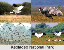
Some of the famous tourist"s attractions in Bharatpur District are Keoladeo National Park, Lohagarh Fort Or The `Iron Fort`, Government Museum, Palace of Bharatpur, Deeg Fort, Gopal Bhawan, Bengal Chamber, Suraj Bhawan, Nand Bhawan and Purana Mahal, Shri Rajendra Suri Kirti Mandir, Gopal Bhavan, Kishori Mehal, Laxmi Vilas Palace, Jawahar Burj, Fateh Burj, Laxman Mandir, Vishwapriya Shastri Park, Bankebihari Temple, Nehru Park, Bayana Fort, Kailadevi Temple Karauli, Fatehpur Sikri, Agra and Dev Narayan Temple (Sarsena).
Visiting Information
Bharatpur is easily connected with the railways, roadways and airways. Bharatpur junction BTE Jn. is located on the main Delhi-Mumbai line as well as the Bandikui - Agra Fort line. One can easily reach here by train from Delhi, Jaipur, Agra, Mumbai, Kota, Jodhpur, Kanpur, Allahabad.


