Introduction
Baran district, located in the state of Rajasthan, was carved out of erstwhile Kota District on 10th April 1991. The district got the name from the town Baran which is also the district headquarters. The district covers a total area of 6955.40 Sq.Km, out of which 35.88 Sq.Km. is urban while the rest is primarily rural. There are eight tehsils in the district namely Baran, Anta, Atru, Mangrol, Chhabra, Chhipabarod, Kishanganj and Shahabad. Baran district comes under the parliamentry constituency of Jhalawar-Baran and is divided into four assembly constituencies namely Anta, Kishanganj, Baran-Atru and Chhabra. The main dialect spoken here is Hadoti. The best time to visit the district is between September to November and it can be easily accessed as well as it is well connected with rail and road network.
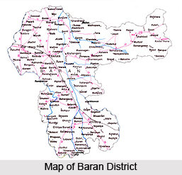
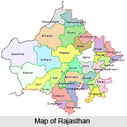
Location of Baran District
The district extends from 24-25 minutes to 25-25 minutes North latitude and 76-12 minutes to 77-26 minutes east longitudes. Located on the south-east corner of Rajasthan and being adjacent to Shoepur, Shivpuri district and Guna District of Madhya Pradesh, Baran district forms the boundary of Rajasthan State. It is bounded on the north-west by Kota, and on the south-west by Jhalawar district of Rajasthan. The maximum length of the district from North to South is 103 Kms. and maximum width from west to east is 104 Kms. The district lies at an altitude of 262 metres above sea-level.
History of Baran District
Baran was under the Solanki Rajputs in the 14th - 15th century. It is not exactly known as to when the main town of the twelve villages under the Solanki`s was named as `Baran`. There are many views as to the same. Some say that it was formed by twelve villages, and is therefore called Baran. Some others say that the city was built by the twelve nearby villages, and is therefore named as Baran. It is also said, that since the soil of the area is mostly Barani, the district has thus acquired its name. In the year 1948, the state of Rajasthan was formed, and Baran was then a district in Rajasthan state. On 31st March` 1949, Rajasthan was reconstituted and at that time Baran district headquarters was converted into Sub Division headquater of Kota district. It is also worth noting that `Baran` in Urdu means rain. It is therefore no wonder that Baran has the second highest rainfall in the state after Banswara district.
Geography in Baran District
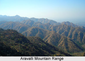
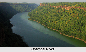
Situated at a height of 262 metres above sea level, the district is located in the south eastern corner of Rajasthan. The maximum length of the district from North to South is 103 Kms. and maximum width from west to east is 104 Kms. The land of the district slopes gently from south to north and the drainage is through Chambal River and its tributaries. The land slopes gently northward from the high tableland of Malwa in Madhya Pradesh. It is well watered, drained by rivers flowing in north and north-eastern directions. The main drainage of the land is through the Chambal River and its tributaries. There are hills in the south, north and eastern portion of the district and it is generally fertile. The highest point, Mammooni, lies among the hills in the east in the Shahabad tehsil. It is 546 meters above mean sea level. These hills form a part of the Aravalli mountain ranges. They have steep and gentle slopes and are mostly covered with woods.
The climate of the district is mostly dry. The winter season extends from mid-November to February, and the summer season runs from March to mid-June. The monsoon season is from mid June to September, and it is followed by the post monsoon season, lasting from October to mid November. The average rainfall in the Baran district is about 854.5 mm. The coldest month is that of January with an average daily temperature of 24 degree Celsius and an average daily minimum temperature of 10.6 degree Celsius.
The main river of the Baran district is the Parvati River, an auxiliary of the Chambal River. This enters Baran from the Kariyahat kasba of Chhabra Tehsil from Madhy Pradesh. It separates the Kishanganj Tehsil from Chhabra, Atru, Baran and Mangrol Tehsils. One of the most important rivers of the Hadoti region is the Kali Sindh River. It flows for around 40 Kms along the western border of the Mangrol tehsil, after merging with the Parvan River. The uncertainty of floods is quite high with this river. One of the largest rivers in the state of Rajasthan, the Palaytha, has been constructed over this river.
The Parvan River is the auxiliary of the Kali Sindh River. It enters the Baran district from the southern part of the Harnavdashahaji kasba. From there, it maintains its flow along the south-western border of the Chhipabarod, Atru, Baran and Mangrol tehsils and merges into the Kali Sindh River. The Andheri River enters Baran from nearby Chhipabarod. It runs for about 15 Kms bordering Madhya Pradesh and Rajasthan and finally merges into the Parvati River near Atru. The Ban Ganga River is the rainy river which passes through Bamla and Sehrod in the southern part of Baran. After passing east of Baran city and west of Bohat and Mangrol Kasba, it merges with the Parvati River. The irrigation facilities available in the district are mainly in the form of canals, tubewells and wells. The rivers Parvati, Kalisindh and Parwan provide an important source of canal irrigation.
Soil found in the district is mainly black Kachari soil, found primarily in the Baran and Mangrol tehsils. This soil is highly fertile. Stony soil is found in the southern and eastern part of the district. Owing to the absence of metamorphic rocks, no metallic ore of importance except Bauxite occurs in the district. However a variety of non-metallic minerals are exposed, important among them being sandstone and limestone. Besides, small deposits of red clay, glass-sand, dolomite and kankar are also found. The main mineral of the district is building stone.
The forest area of the district is around 2.15 lacs. The forests are mainly concentrated in the south-western and central portion of the Mukundra hills, which have a rich forest belt. The main forests found of the district are Sagavan, Kher, Salan, Gargsari. Local wild animals are panther, sloth, bear, chital, wild bear, chinkara, sambar, langoor, jackal etc. Birds found in the district are bulbul, sparrow, peacock, saras, teetar etc. Among the poisonous snakes, cobra, passel and viper are common. Water snakes are also seen near the tanks. Crocodiles are sometimes seen in the big tanks and in certain pools in Chambal and Kali Sindh rivers.
Economy of Baran District
The major industries in Baran district are primarily agro-based. These include soyabean, mustard oil, pulse/rice mills, coriander and wheat grinding, agricultural instruments, minerals based units like stone crashers etc. National Thermal Power Corporation (NTPC), A Government of India enterprise is also situated in Anta which produces electricity based on the Gas. Rajasthan Financial Corporation (RFC) is a leading financial institution of the state which caters to the industrial and financial requirements of the medium, small scale and tiny industrial units. For setting up the industrial units in the district, RIICO provide land and infrastructure facilities, technical consultancy and financial inputs. There are three industrial areas in the district.
District Industries Centre
The District Industries Centre (DIC) programme was introduced for the first time in the state in July` 1978 for providing the necessary support services under one roof for industrial development in the district. Kota, which is the major industrial town of the state, is just 72 km. from Baran where Industrialisation had taken roots in the early sixties. Though Baran was formerly a part of Kota but it remained backward. After the creation of the district of Baran, the DIC was established at Baran in September 1992. A number of schemes have been introduced by the DIC.
Some of these are discussed below.
1) Pradhan Mantry Rozgar Yojna (PMRY): In this scheme training is provided for the educated unemployed for setting up their own industries. Under the scheme, an educated unemployed person of 18-35 years, minimum 8th class pass, family income not more than 40,000/- per year and residing at that place for 3 years is eligible. Assistance is provided for the loan from banks. A number of unemployed have been benefited by the District Industry Centre (DIC), Baran till date.
2) House Hold Industries (HHI): In this scheme women are provided weaving and sewing training for setting up their own business.
3) Kargha Ghar Subsidy: Subsidised loan is provided under this scheme to setup Kargha Ghar in the district.
4) Eye-Testing for Weavers: Eye testing of the weavers is done under this scheme. Weavers are also provided free glasses.
5) Insurance for Weavers: Under this scheme, insurance is provided for the weavers. 20 percent of the money is put in by the weavers and 40 percent by the state government. 60 percent comes from the central government.
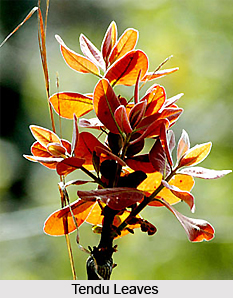
The District has a tremendous scope for the rapid industrialisation, especially among agro-based industries. The main forest produce of district is `Tendu leaves`. So `Bidi`, Dona-pattal units are beneficial in the district. The minerals produced in the district are limestone, sandstone, building stone etc. so the units based on the above stones are also beneficial.
NTPC, Anta
The NTPC (National Thermal Power Corporation) Limited at Anta is the largest power generating company of India. It is a public sector company owned by the Government of India. It was incorporated in the year 1975in order to accelerate power development in the country. The NTPC Anta Project is located about 23 Kms from Baran district headquarters, close to the Anta town of the district. Anta project is the first in a series of combined cycle power projects set up by NTPC in different parts of the country. The installed capacity of first stage is 413 MW comprising 3 gas turbines of 88 MW each and a steam turbine of 149 MW. All the units were synchronised ahead of schedule.
Fairs and Festivals in Baran District
Fairs and festivals in Baran district figure many in number. A variety of festivals are held in the district as a part of the celebrations of various religious groups. These festivals and fairs are organised on a large scale and celebrated with much pomp and fanfare. The events are participated in and attended by a number of people from all over the state, and the celebrations continue for days on end. Discussed below are the various fairs and festivals in the district of Baran.
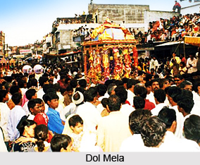
Dol Mela: The Dol mela is organised at the Dol Talab (Pond) in Baran city from Jaljhulni Akadshi. The main attraction of the mela is a big Shobha Yatra (procession) which has about 54 Dev Viman (the holy statue carriers). This procession is also known as Dol, and the procession goes around al the major temples of the city. In this procession some `Akhadas` also demonstrate their `Kartab` (type of physical exercise). The procession starts from the Shreeji temple, comes to the Dol Talab where all the Dev Vimans are worshiped and then these are sent back to the respective temples. This fair is organised for 15 days and it is very popular among the local residents as well as the residents from all over the state of Rajasthan. People from adjoining Madhya Pradesh also visit for fair. This fair is the symbol of communal harmony in the area, and one of the main fairs of the Rajasthan state.
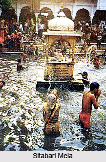
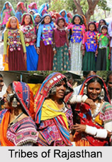
Sitabari Mela: Sitabari Mela is another major fair in the district of Baran. Sitabri is a holy place situated about 45 Km. from Baran city near the Kelwara Kasba. A big tribal fair is organised here on Jeshta Amavasya. The place has a number of `Kunds` attributed to Sita, Laxman, Lord Surya, Lav and Kush and taking a holy dip in them is considered auspicious. Lakhs of people come here for this fair which is taken as Kumbh in the Sahariya tribe. The Swayambar (marriage function) of Sahariya tribes is organised in this fair which is attended by people come from all over Rajasthan state and adjoining Madhya Pradesh. In the Swayambar of the Sahariya tribe, the Sahariya tribe a sahariya boy drops the handkerchief for proposing to the Sahariya girl in the fair. If the girl accepts the handkerchief, it is said that they are agreed for marriage. The bride and groom take the 7 rounds (saat phere) of the Barnawa tree and after the blessings of their parents they are accepted as a married couple.
Brahamani Mataji Mela: The Brahamani Mataji Mela is organised in the old fort near Sorsan about 20 Kms from Baran. This is the only donkey fair in the Hadoti region. Brahmani Mataji temple is in this fort. This fair is organised in Magh-Shukla-Saptmi. Other animals are also brought for selling-purchasing in this fair but mostly donkey and kachhar are sold and purchased in the fair.
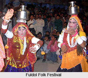
Phuldol Folk Festival: One of the oldest folk festivals of the state of Rajasthan is the Phuldol Folk Festival. The festival is organised every year in the town of Kishanganj on the occasion of Holi. This festival was started more than 120 years ago by the local residents of the town with the marriage ceremony of the tulsi plant with the statue of God Charbhujanath in their home. It is a tradition in the families that after marriage, the groom comes to the in-laws home with his friends to play Holi. This tradition is followed by the God Charbhujanath and all the residents of Kishanganj town. On the day of Holi-Dulandi, Swang (type of drama) is played in the town for the whole day. Some of the famous swangs are Gidh-Rawan-Yudh, Band-Bandi swang etc. In the night, a big `Shobhayatra` known as `PhulDolo` is taken out into town. Lots of people from nearby places come to witness the festival.
Piplod Christmas Fair: Piplod Christmas Fair is organised in the only Church of the Baran district in the village Piplod in Atru tehsil. This fair is organised on 25th December every year. Though this fair is organised near the Church, many local Hindu-Muslims also participate in the fair.
Urs: About 33 Km. from Baran, there is a small village called Balakhera. Here, Urs has been celebrated for the last 33 years. It is interesting to note that this Urs was initiated by a Hindu Brahmin family. Even today the flag of the Urs is taken out from the house of the descendant of this family.
Tourism in Baran District
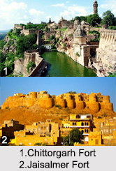
There are a number of places of tourism that the district of Baran has to offer the visitors. Many ancient temples are found located all over the district, such as the Brahmani Mataji Temple, temples at Kakoni, Sitabari etc. The Shiv Mandir of the Ramgarh-Bhand Devra temples has been built in the classic style of the Khajuraho temples and is hence often known as the Khajuraho of Rajasthan. Apart from the many beautiful temples located here, there are a number of places of historical interest located here in the district. Prime among them are the many forts that have been constructed here by the erstwhile rulers and conquerors of the district.
Leisure tourism in Baran district is like a walk down history. There are a number of places of historical importance situated in the district of Baran, such as forts and ancient places of antiquity which are of great worth. Discussed below are the various places of leisure tourism in Baran district.
Bilasgarh: Bilasgarh is situated about 45 Km. from Baran in Kanyadeah tehsil. The connecting road is from the Faldi village between Kishanganj and Bhanwargarh. Bilasgarh was once a big city during the Khechi kingdom. It was destroyed and left in ruins on the orders of Aurangzeb. The daughter of the king Khechi was supposedly very beautiful and it is said that it was because of her that sent his forces to Bilasgarh and ultimately ruined the city. The princess ended her life in the Bilasi River and the spot is now known as Kanyadeah. The ruins of the Bilasgarh are still situated inside the dense forest area.
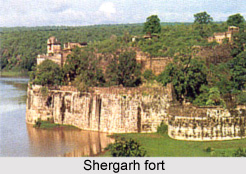
Shergarh Fort: The historic Shergarh fort is situated about 65 Kms. from Baran district headquarters in the Atru tehsil. Sitting atop a hillock on the bank of the Parban River, the fort of Shergarh looks impregnable. The fort stands a little detached from the walled township, which boasts of its ancient Brahmanical and Jain temples. A stone edict of 790 AD proves the antiquity of the place, which was once known as Koshvardhan. The fort is one of the best forts in Rajasthan in the present time.
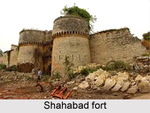
Shahabad Fort: Shahabad fort is the one of the best and strongest forts amongst the forts in the Hadoti region. It is situated about 80 kms away from Baran, in a dense forest area among high mountain ranges. The fort was constructed by the Chauhan Vanshi Dhandhel Rajput Mukutmani Dev in the century 1521 (Samvat 1577). The fort is surrounded by Kundakoh valley on two sides. The third and fourth sides are surrounded by ponds and high rocks respectively. The Topkhana (artillery), Barudkhana and some temples in the fort are still secure. It is said that the fort had 18 Cannons (Topes) in the past and one of them was 19 feet.
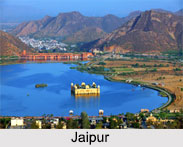
Nahargarh Fort: Nahargarh Fort, Jaipur is about 73 Km. from Baran in Kishanganj tehsil. The fort is an impressive structure in red stone and a fine example of Mughal Architecture.
Kapildhara: Kapildhara is about 50 Kms from Baran District. The place has great natural beauty and is a pleasant spot for visiting. Water flows all the time from the 'Gaumukh' in the mountains.
Kakoni: Kakoni is situated about 85 km from Baran district Headquarters in the Chhipabarod Tehsil. Kakoni is surrounded by the Mukundra mountain ranges and on the bank of Parwan river. It is said that the temples at Kakoni are built in 8th century. These are the remains of the Vaishnav, Shiv and Jain temples.
Pilgrimage tourism in Baran district will be full of visits to ancient temples. There are a number of temples situated here which have been constructed in the olden days. Remains of these temples are found scattered all over the district. Apart from the temples, a Masjid, constructed during the time of Aurangzeb, is also found in the district, The various places of pilgrimage tourism in the district of Baran are discussed below.
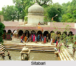
Sitabari: Sitabari is situated about 45 Kms from Baran in Kelwara kasba on National Highway road connecting Shivpuri-Gwalior. This is one of the most places of pilgrimage in the district. It is popularly held in the area that `Sita mata` had lived in this place after being left by Lord Rama. This place is also known as the birth-place of Luv and Kush. There are several Kunds in Sitabari namely Balmiki Kund, Sita Kund, Laxman Kund, Surya Kund, Lav-Kush Kund. Sita-Kuti is also situated in the forest area near the temple. The tribal Sahariya fair is held at this place in the May/June every year. Sitabari also serves as an ideal picnic spot.
Kakoni: Remains of Vaishnav, Shiv and Jain temples are found here. Most of the statues of the Kakoni temples are kept in the museums at Kota and Jhalwar district. Archaeological department has announced the place as secure since 1970.
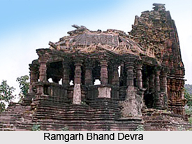
Ramgarh-Bhand Devra Temples: Ramgarh-Bhand Devra temples are situated about 40 Kms from Baran. The place has been named thus due to the Maithun statues found here. The Shiv Mandir of Ramgarh was built in the 10th century and is based on the style of the Khajuraho temples. It is thus often known as Rajasthan's mini Khajuraho. The temple is situated along the banks of a pond, and is now under the archaeological department. On the top of the Ramgarh hill, the Kisnai and Annapurna Devi temples are situated in a natural cave. About 750 stairs were constructed by Jhala Jalim Singh for reaching the temple on the hill top. The main speciality of this temple is that one Devi is worshiped with Meva and another is worshipped with Mas-Madira. At the time of Parshad, a curtain is raised between the two Devis. A fair is also organised during Kartik Purnima.
Brahmani Mataji Temple: The Brahmani Mataji Temple is about 20 Kms away from Baran in the village of Sorsan. The statue of Brahmani Mata is situated under a large natural rock in the cave. The Akhand Jyoti has been continuously flowing in the temple since the 400 years. A fair is organised on Shivaratri every year.

Tapasviyo ki Bagechi: Tapasviyo ki Bagechi is situated nearly 1 Km from Shahabad city. Found here are large statues of Shivling and Nadiya. This beautiful place is surrounded by mountains and a place of great natural beauty. The place was used for betel farming previously, and the remains of the same still exist in a ruined state.
Shahi Jama Masjid is situated in Shahabad city and 80 Kms away from Baran city. This masjid was beautifully constructed during the reign of Aurangzeb. Its pillars and mehrab are beautifully constructed and worth seeing.