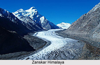
 Zanskar is the basin of the Zanskar River and its tributaries. Zanskar Himalayan range is located south of the district of Ladakh. The Zanskar region is bounded by high mountains and it remains cut off from the rest of country for a major part of the year. The single route to Zanskar region leads over really high and dangerous passes via the main ranges of Himalaya Mountains. This only route remains open during certain specific times of the year. In the winter season, the Zanskar River is the only route through which this region can be accessed. Zanskar Himalayan range stretches from the edges across the Zanskar region beyond Lamayuru in the west. At this zone it is divided from the main Himalayan chain.
Zanskar district lying south of Ladakh receives its name from the river which flows north from Padam in Central Zanskar and which, with its many tributaries, finally joins the Indus a little west of Leh. It forms a great canyon and flows through vast plains. Zanskar has always been the most inhabited part of Ladakh, with several small villages that maintain close contacts with Kashmir, Lahul and Kishtwar. It has many gompas, and trade routes across the area - to its south lies Kishtwar with its jagged peaks; the Shingo la in the southeast leads to Lahul and to the northwest is Kargil and the road to Kashmir. It is one of the more popular areas for the trekkers and apart from that there are certain selected areas too. Peaks rising south of Padam and all peaks bordering Kishtwar can be accessed from Zanskar. The chief attraction of Zanskar range is Nun (7135 m) and Kun (7087 m).
 Nun Kun Peaks
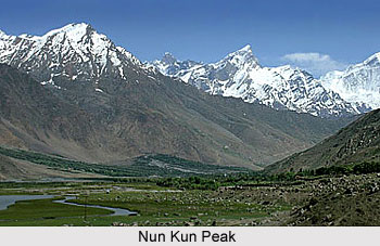
 is the most important massif in the Kashmir Himalaya. Standing at the edge of the Zanskar Mountains it is a group of high summits - Nun (7135 m), Kun (7087 m) and Pinnacle Peak (6952 m). The massif stands on the Great Himalayan Axis in line with Nanga Parbat and lies immediately south of Tongul at the bend of the Suru River which joins the Shingo tributary of the Indus about eight km below Kargil. Between Nun and Kun is a high snow-plateau ending in a broken icefall and then descending further to become the eastern branch of the Parchik glacier. The main branch of this glacier drains the west ridge of Nun. The southeastern slopes of Pinnacle Peak flow into the Shafat glacier and eventually into the Suru River. The southern slopes drain into the Fariabad river which passes south through Kishtwar.
Nun Kun Peaks
Nun Kun Peaks is the most important massif in the Kashmir Himalaya. Standing at the edge of the Zanskar Mountains it is a group of high summits - Nun (7135 m), Kun (7087 m) and Pinnacle Peak (6952 m). The massif stands on the Great Himalayan Axis in line with Nanga Parbat and lies immediately south of Tongul at the bend of the Suru River which joins the Shingo tributary of the Indus about eight km below Kargil. Between Nun and Kun is a high snow-plateau ending in a broken icefall and then descending further to become the eastern branch of the Parchik glacier. The main branch of this glacier drains the west ridge of Nun. The southeastern slopes of Pinnacle Peak flow into the Shafat glacier and eventually into the Suru River. The southern slopes drain into the Fariabad river which passes south through Kishtwar.
In the year 1898, C. G. Bruce and Maj F. G. Lucas were the first climbers at this Himalayan range. Again in the year 1902 and 1904, Dr Arthur Neve and Rev C E. Barton came up the Shafat glacier and made some sketches of the area to correct the old inaccurate maps. The Dutch traveller, Dr H. Sillem, explored the high plateau between Nun and Kun in the year 1903 and was followed by the Americans, Dr Bullock Workman, in 1906, made some more surveys and climbed Pinnacle Peak. The first ascent of Kun was by the Italian Count Piacenza, in the year 1913. His party climbed via its northeast ridge, approaching from the snow-plateau in the south.
Attempts on Nun continued for some more years. J. Waller tried the East Ridge in the year 1934 and eventually climbed `White Needle` (6599 m), immediately to the east of Nun. He returned in the year 1937 to try the west ridge. He was followed by R. Berry in 1946 and by the Swiss, P. Vittoz, in 1952. Finally P. Vittoz and Mme C. Kogan, members of a French expedition led by Bernard Pierre climbed Nun by the west ridge from the Fariabad valley in the year 1953. All the major summits of the area have been climbed. Today, Nun-Kun and the surrounding area have become one of the most visited and popular climbing arenas.
The second ascent of Nun was made in the year 1971 (Indian, K. P. Venugopal) by its east ridge. In 1975, a Swedish team climbed the west ridge again. The new routes on this peak are the northwest ridge (Czechs, 1976); west face (Austrians, 1980) and the north face (Americans, 1980). Kun received its second and third ascents in 1971 and 1978 respectively, both by the Indian Army. The west wall of Kun was climbed by the Japanese in the year 1981 after a twelve-day ordeal. They reached the summit twice. Both Nun and Kun have suffered skiers, Sylvia Saudan on Nun in the year 1977 and the Indian Army on Kun in the year 1978. Now they are being climbed by the various routes.
Peaks in Zanskar Himalayan range near Nun-Kun are numbered with a prefix `Z`. These peaks lie on the margin of the Durung Drung glacier, and have become an important climbing region in the range of Zanskar Himalaya, which offers plenty of excellent prospects. The Z group of peaks has been visited only in recent years. The exception to this is Z3 (6270 m) which was climbed by Piacenza of the Italian expedition in the year 1913. The second ascent was made sixty-eight years later, in the year 1981, by another Italian expedition (G. Agostoni).
Zl (6181 m) was climbed by the Japanese (M. Ouchi) by its southwest ridge, Z2 (6175 m) by the Italians in the year 1977 by its south ridge. They came over a high pass from the Pensi glacier into the Rumdum glacier. Earlier they had climbed Z8 (6050 m) by its northwest ridge from the Pensi glacier. All these were first ascents. In fact, after the first ascent of Kun in the year 1914, it has become a very popular hunting ground for the Italians, closely followed by the Japanese who have also climbed a number of unnamed summits. A number of parties have, in the last few years, visited the mountains at the head of the Durung Drung glacier. It flows north and slightly east from the Kishtwar-Zanskar watershed towards the Pensi la.
In the year 1977, G. Cohen, R. Collister and D. Rubens made some serious climbs. Returning in the year 1983, G. Cohen with C. Huntley made some more ascents. Two Italian expeditions, A. Bergamaschi in 1980 and G. Agostino in 1981, climbed several peaks in the area, giving Italian names and heights by altimeter. Amongst other visitors were those from the Edinburgh University (1983), Alan Hunt (1983), Joss Lynam (1983) and K. Sakai with a Japanese party (1985).
Zanskar Himalayan range passes to the North of Kinnaur and Spiti and this range that is close to the India-Tibet border is considered close to the trekkers.


