 Geography of Ladakh which includes a number of valleys, passes, mountain ranges, glaciers and long stretched cold desert is one of world`s largest and highest plateaus located at 3000m and 9800ft above the sea level. Located in the foot hills of great Karakoram Range and the great Himalayas this small region is known for its distinctive geographical composition which has its own description.
Topography of Ladakh
Geography of Ladakh contains wide mountain ranges which have been estimated to have originated over a period of 45 million years by the folding of Indian Plateau into a stationary landmass. The result of this transformation has been marked visibly in the still growing Himalayan ranges and the region of Ladakh which has been formed with the sediments of old Tethys sea and the old soil of Indian peninsula. Besides this the District of Ladakh includes the Zanskar range which consists of layers of sediments from the ocean floor; this is further enriched with wide range of Granite born from the immense heat generated by the fiction of the two tectonic plates. The region further consists of the Suture zone which runs from the south of the Indus valley. All this have added to the contraption in the region which has made the area prone to frequent Earthquakes and creation of drifts in the area. As such the area also consists of a number of passes between its mountain ranges among which the Zoji-la Pass is most commonly used which connects the region with Indian mainland. Along with the Zoji-la pass the area of Ladakh does not have any high mountain peak; its highest mountain peak reaches a height of 5000 to 5500 m above the sea level, south east of Zoji-la reaches a bit more height with a height up to 7000m above the sea level between the two summits.
Some of the major areas which exist along with Ladakh include Srinagar and Anantnag formally located in the Kashmir Valley is situated in the west of Ladakh while Lahual and Spiti located in Himachal Pradesh is situated in the south of Ladakh and the foreign land of Kyrghistan is located in the extreme north.
 Valleys of Ladakh
Geography of Ladakh then includes a number of valleys. Most important among them are the Suru valley and the Zanskar valley which forms the foot of the northern part of Himalayas. The Suru Valley receives a common water from Drass and Shingo river and joins the Indus at Marol in Baltistan. The area further consists of the Indus valley three of which are closely situated near the Line of Control and Pakistan controlled PoK. The valleys are mainly inhabited with the bakerwals and nomadic herdsman people who travel from the north of Jammu and Kashmir and aims to reach the valleys of Ladakh.
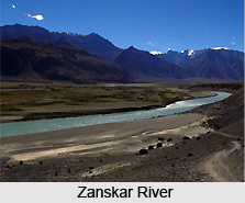
Rivers Of Ladakh
Geography of Ladakh is largely dependent on two particular river streams which mainly flow in the Zanskar region. These are Stod also known as Doda and Lungnak which is commonly known as Tsarap Lingti. The tributaries of Lungnak River mainly originate near Rupshu. The Stod River carries the water of Drang-Drung glacier which flows down towards large open valley towards Lungnak. Along with this the Zanskar River too enters through a gorge to join Indus at central Ladakh. Among the two rivers Zanskar suffers heavy snowfall. The Indus River is the backbone of Ladakh and all the major regions like Shey, Leh, Basgo, and Tingmosgang. The area also receives water from the Shyok River and the Nubra River which originates just below the Karakoram Range.
Mountain Ranges and Passes of Ladakh
Geography of Ladakh is mainly marked by the wide extending Karakoram Range. Though the region does not possess any of the highest mountain peaks, its highest point is 6000m from the sea level. The mountain range of Ladakh forms the boundaries of the Indus valley which enters Ladakh at Demchok. The Shyok and Nubra Valley consists of some of the highest points of Ladakh which has been named as the Apsarasas groups (highest point 7245 m), Rimo group (highest point 7385m), Teram Kangri group (highest point 7464m), Momostong Kangri (7526)m and Singhi Kangri (7751m) which lie in the Kunlun mountains. Thus the area includes Ladakh range, Karakoram Range and Kunlun.
Thus, the geography of Ladakh and its location between India and Tibet gives it a strategic importance as well which works as a dividing line between India and Tibet along with China.


