Barren Islands
|
Barren Islands is located in the Andaman Sea and is one of the best-known volcanic islands of the world.
|
|
|
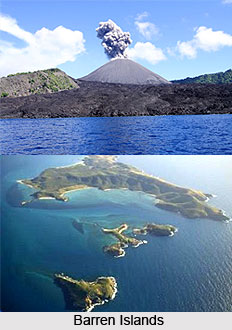 Barren Islands is located in the Andaman Sea and is one of the most easterly of the Andaman Islands. The strategic location of Barren Islands is 12°16?N 93°51 ?E and 12.267°N 93.85°E. Barren Islands is the only confirmed active volcano in South Asia. The island, along with the rest of the Andamans, is part of the Indian union territory of Andaman and Nicobar Islands, and lies some 135 km northeast of the territory's capital, Port Blair. The first recorded eruptions of the volcano on Barren Islands date back to 1787. Since then, the volcano has erupted more than six times and the most recent eruption was on 2 May 2006. Barren Islands is located in the Andaman Sea and is one of the most easterly of the Andaman Islands. The strategic location of Barren Islands is 12°16?N 93°51 ?E and 12.267°N 93.85°E. Barren Islands is the only confirmed active volcano in South Asia. The island, along with the rest of the Andamans, is part of the Indian union territory of Andaman and Nicobar Islands, and lies some 135 km northeast of the territory's capital, Port Blair. The first recorded eruptions of the volcano on Barren Islands date back to 1787. Since then, the volcano has erupted more than six times and the most recent eruption was on 2 May 2006.
After the initial eruption of Barren Islands in 1787, further eruptions were recorded in 1789, 1795, 1803-04, and 1852. After nearly two centuries of dormancy, the Barren Islands had another eruption in 1991 that lasted six months and caused considerable damage. There was another eruption in 1994-95 and the most recent one occurred in 2005. The latest eruption on Barren Islands is considered to be associated with the 2004 Indian Ocean earthquake. After the recent eruptions, the Barren Islands, which still experiences, the strange tremor is being preserved and protected as a niche tourist destination as the tsunami-battered territory seeks to bring in more revenue to the nation.
This volcanic island stands in the midst of a volcanic belt on the edge of the Indian and Burmese tectonic plates. There are other extinct sea and land volcanoes in the zone of Barren Islands, and a volcano Narcondum has been reported for its volcanic activity. The peak of the volcano rises to an altitude of 354 metres (1,161 ft), but most of the volcano in Barren Islands is underwater (standing on the seabed 2250 meters below the surface). The island is 3 km long with a total surface area of 10 km²; the caldera of the volcano is 2 km wide.
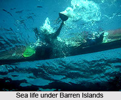 Justifying its name, Barren Islands is a barren area uninhabited by humans, though with a small population of goats. Also birds, bats like flying foxes and a few rodent species such as rats are known to survive the harsh conditions of the region. An eruption began on 28th May 2005. An ash plume was erupted from a vent on the W side of the summit. Lava flows were produced and the great Sumatra earthquake in December 2004 may have precipitated the eruption. Continued ash emissions have been reported between 2005 and 2008. Much earlier, an eruption began at Barren Island volcano on 20th December 1994. In January 1995, Strombolian eruptions were noticed and lava flowed 1.5 km from the active vents into the sea. On 8th March 1995, phreatomagmatic eruptions occurred. On 11th May 1995 fire fountains from the central vent rose to a height of 150 m. Explosive activity in the crater of Barren Islands finished by 1st July 1995. During in April 1991 eruption, explosions and lava flows occurred at Barren Island volcano. Lava flowed from a vent on the northeast face of the central volcanic cone. Explosions at the vent occurred at intervals of several seconds, ejecting bombs, lapilli, and ash up to 50 m high.
|
|
|
|


