 Andaman and Nicobar Island topography shows distinctive topographical features, with the presence of a number of islands in a long and broken chain. The landscape of Andaman and Nicobar Islands is, geologically, a part of land mass of South-east Asia, including Malaysia, North-East India, Burma, Thailand and Indonesia.
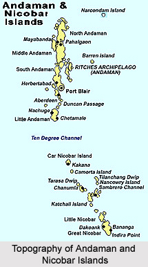
Away from the mainland of India and situated in the Bay of Bengal, the Andaman and Nicobar Islands is a cluster of 321 islands. If the islets, reefs and rocks in this Archipelago are also considered to be the part of Andaman, the number swells up to 572. From these islands only 38 are inhabited - 26 in the Andaman group and 12 in the Nicobar group of islands.
These clusters of islands extend over 700 km., with an area of 8249 sq. km. These form a long but narrow broken chain in the shape of a semicircle, and are located between 6°and 14° North latitude and 92° and 94° East longitude. The northernmost island is Landfall Island. It is situated at a distance of 190 km. from Cape Negrais of Burma (now known as Myanmar). However, the southern-most end of the Coco Island under Myanmar is only around 35 km away from the northern end of Landfall Island and these islands are separated by Coco Channel. In the south, there is a point named "Pygmalion" point (which has been renamed as Indira point in Great Nicobar Island) is the southern-most point in the Andaman and Nicobar islands. It is only 150 km. away from Banda Achin, the northern end of Sumatra.
These islands of unmatched beauty, encompassing within their borders, outstanding wonders and sun-kissed sea-scapes, attract a whole lot of Indians as well as foreign tourists. Port Blair is the only township in the south Andamans, and serves as the capital of this union territory. It is approximately 1255 km. from Kolkata, 1200 km. from Vishakhapatnam and 1190 km. from Chennai.
These islands are divided into two districts: (1) Andaman, consisting of the Andaman group of islands and (2) Nicobar, consisting of the Nicobar group of islands.
1. Andaman Islands
The Andaman group consists of approximately 259 islands. From Landfall Island in the north up to Little Andaman Island in the south, these islands stretch around 464 km. in length, with a maximum width of nearly 51 km. (average width being 24 km.). The cluster is spread over an area of approximately 6408 sq. km. These islands (with the exception of the Little Andaman) are situated in such close contact that they appear to overlap each another and hence they have long been known as the `Great Andamans`. The major groups of the Andaman Islands consist of: (i) the North Andaman including the Landfall island, the Narcondam island, the Sound island etc., (ii) the Middle Andamans including the Interview island, (iii) the South Andamans including the Baratang island, the Ritchie`s Archipelago, the Neil island, the Rutland island, the Ross island etc., and (iv) the Little Andamans. These hilly island arcs covered with impenetrable evergreen forests and are separated by trails and coves.
On the east of the Great Andaman lie two volcanic islands - the Narcondam and the Barren islands. The Narcondam Island is one of the Pegu groups of volcanoes and the Barren Island is one of the Sunda group. The Narcondam Island is a towering peak ascending 2300 feet above the sea out of unfathomable water. It is approximately 4 km. long and 2.5 km. wide and is uninhabited. The name of this island, Narcondam is believed to be a derivation from the Sanskrit word `Narak-Kund`, which means `Pit of Hell`.
The Barren Island is volcanic in nature emerging from water to a height of 1150 feet above the sea level. Circular in shape and with a diameter of almost 3.5 km., it has been in a state of active eruption for an extensive period of time. A thin column of steam emerges from a sulphur bed on the side of the cone near the top and a hot spewing at the base generates an average temperature of 107° F. The volcano had erupted last on 2 May 2006, which is most definitely linked with the devastating 2004 Indian Ocean tsunami. It is, however dormant since then.
2. The Nicobar Islands
The Nicobar group of islands consists of approximately 61 islands. From the Car Nicobar Island in the north and the Great Nicobar Island in the south, these islands are almost 259 km. in length and have a maximum width of 58 km. The major islands of the Nicobar group include Car Nicobar, Teressa, Katchal, Kamorta, Nancowry, Little Nicobar and Great Nicobar, extending towards the southern Pygmalion point, renamed as Indira Point.
The Little Andaman island (the Andaman group of islands) and the Car Nicobar island (Nicobar group of islands) are located at a distance of nearly 145 km. from each other and are separated by the 10ø North latitude channel with a depth of 400 fathoms.
Over 90% area of these islands is covered with evergreen tropical rain-fed forests, while 86% area is declared as notified forest reserve under the Indian Forests Act.
The topography of the area of both these groups of islands is commonly hilly and rippling. The flat islands are relatively less in number. The main hill range runs from north to south. The Saddle Peak in the North Andaman, placed at the height of 132 metres above the sea level is the highest point in the islands. The Mount Thulliar in the Great Nicobar is 642 metres high and the Mount Harriet in the South Andaman is 365 metres high from the sea level. The slopes are moderate, sometimes ranging from steep to rugged. The land of a few islands in the Andaman district are quite craggy and ridged, but that of most of the Nicobar islands is flat and is surrounded by coral reefs and shallow seas, covered with stretches of sandy beaches. On both sides of the coastline of the Andamans and the Nicobars, the sea hastily deepens to 1000 fathoms and there from to the west of Bay of Bengal to over 2000 fathoms, 96 to 170 km. offshore from this group of islands. The coastline on both sides is severely indented and there are a number of safe harbours. But due to the thick undergrowth of cane and swamps, certain places are impassable.
These islands demonstrate a uniform tropical, warm and humid climate. The normal annual rainfall is 318 centimetres, but it is irregular. It ranges from approximately 300 cm. in the north to about 380 centimetres in the south. The major precipitation occurs during the south- west and north-east monsoons from April to November. These islands are subjected to cyclonic winds and gales, generally common with the change of monsoons and sudden depressions in the sea around. The maximum and the minimum temperatures are 30°C and 23°C respectively. The mean relative humidity is about 78%, while mean wind speed is approximately 10.8 km. per hour.


