Introduction
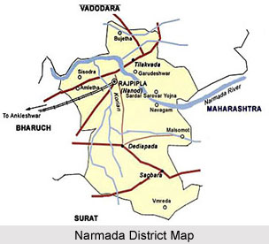 Narmada district is situated at the southern part of Gujarat. Rajpipla is the district headquarter and the main industrial town of Narmada district. The area of the district is 2755 sq. km. As per 2001 census, the population of Narmada district is 5, 14,404 with 187 Persons per sq. km. There are quite a few tourist destinations in Narmada district like Rajwant Palace, Shoolpaneshwar Wildlife Sanctuary and Shoolpaneshwar Temple, and Sardar Sarovar Dam.
Geography of Narmada District
 The surrounding natural landmark forms the geography of Narmada River. The Narmada Valley is one of the vital forms in the geography of Narmada River. Below the Vindhyachal scarps, the narrow valley of the Narmada lies. The River flows across this valley and the valley occupies the southern part of the district in Manawar tahsil and the southeastern part of Kukshi tahsil. The width of the valley is 15 to 30 kilometers. The height varies from 275 meters in the northern part of Manawar tahsil to 150 metres in the low plain of Nisarpur in the southwest. Khalghat and Bakaner lie in the western side of the valley and the valleys is undulation wider, more open and fertile with alluvial cover. Proceeding westwards the valley is embedded with hills alternatively give birth to numerous streams, which join the Narmada along the southern boundary of the district. The result is that there are few stretches and pockets of alluvium silt along the streams.
The River System of Narmada is also credited for its unique geographical features. The southern part of Madhya Pradesh lies in the catchment area of the Narmada River. The river forms the southern boundary of the state. The Chambal and its tributaries drain the northeastern parts of Madhya Pradesh. The Lower course of River Narmada forms the catchment area of the Ganga. The northwestern part drains into the Mahi. The water-dividing line between the Narmada and the Chambal and the Mahi are divided by the offshoot range, which runs along the boundary of Sardarpur-Jhabua.
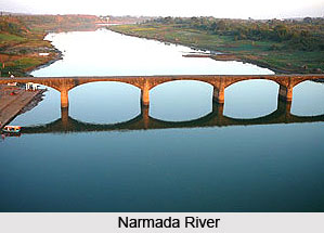
The Narmada River flows along the southern boundary of the district in a rift valley from east to west with a southerly inclination. It rises from the Amarkantak plateau of the Satpura range in Shahdol district. The river flows to the west it crosses the district at Lasangaon at the confluence with the Karametre It forms the southern boundary of the district along with that of the West Nimar for about 107 Kilometres. It receives the streams including Dob, Boad, Mahali and Goi on its left while the Man, the Karam, and the Bagh on its right bank.
In the central parts of India the river is held to be far more sacred than any other stream in India. Even Ganga herself comes and dips in these waters once a year. She comes in the form of a coal-black cow and dip in these waters once a year. She comes in the form of a coal-black cow and returns home pure white, freed from all sins. A sighting of the Narmada is considered equivalent to a bath in the Ganga. At numerous places along its course there are temples, and fairs are held. Pilgrims perform Pradakshina along the riverbanks while walking along the southern bank from its source to the mouth and going back along the northern bank. The performance is regarded to be of the highest religious value. Roads at Khalghat and Chikhalda in the district cross the river. Ferries supervised by the local administration at important crossings carry out navigation across the river.
Valleys of Narmada
 The valleys of River Narmada are not only historically important, but also economically important. In present days, these valleys are the foundations for the various handicraft works and other small-scale industries. In Indian history, Chalukya emperor Pulakeshin II defeated emperor Harshavardhana of Kannauj on the banks of Narmada. The valley of the river Narmada has been the seat of continuous flow of human civilization dating from pre-historic times.
Attractions of Valleys of Narmada
The valley is famous for stunning Maheshwari sarees, which are hand-woven and comfortable in both humid weather and cold weather. These sarees are not only elegant but also light and easily manageable. These sarees have been very popular among the Indian women. The lower Narmada River Valley and the surroundings cover an area of 169,900 kilometres which covers the dry deciduous forests. The eco region lies between moister forests which are found within the routes like the northeast, southeast and southwest. These parts receive greater rainfall from the southeast monsoon and the drier forests with the scrublands of the Deccan to the south, Malwa, and Gujarat to the west and northwest.
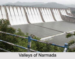
Narmada Valley Project
The Narmada Valley Project intends to connect the stream of the economic wealth for the concerned areas. The whole project includes the construction of 30 major, 135 medium and 3,000 minor dams on the river. The full curves of the Narmada Valley Development Plan emerged only towards the late 1980s. It is a grand plan which imagines the building of 30 big dams. The struggle of the people of the Narmada valley against the large dams began when people displaced by Sardar Sarovar Project began while organizing it in 1985-86. Since then, the struggle spread to cover other major dams in various stages of planning and construction mainly the Maheshwar, Maan, Narmada Sagar, Goi and Jobat. Tawa and Bargi Dams were completed in the year of 1973 and 1989 respectively. Of the 30 big dams proposed in the Narmada River valley, Sardar Sarovar Project (SSP) and Narmada Sagar Project (NSP) are the largest dams. The Maheshwar and Omkareshwar dams along with Sardar Sarovar Project and Narmada Sagar Project are to form a complex which would finally cater to the requirements of SSP.
Demography of Narmada District
 According to the Population Census in the year 2011, Narmada District had population of 590,297 of which male and female were 301,086 and 289,211 respectively. The population of Narmada District constituted 0.98 percent of total population of Gujarat.
Education in Narmada District
In Narmada district there are 663 primary, 56 secondary and 23 higher secondary schools. There are 6 ITIs offering several industrial training programs which include fitting, computer operations and diesel mechanics, etc. Some of the colleges present in the district are M.R. Arts and Science College and Ratnasinhji Mahida Commerce College.
Economy of Narmada District
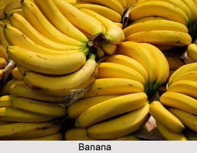
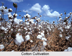 Economy of Narmada District in Gujarat state is primarily agrarian. A major stratum of population is reliant upon agriculture for their source of revenue. Production of banana and cotton are the most important horticulture crops in the district. Industries such as textiles, sugar, and chemicals observed major investments and considerable growth during the past two decades. Over eight hundred and sixty Small Scale Industries (SSIs), engaged in repair and services, paper, wood products, and food products are present in the district of which over three hundred and ninety units are present in Nandod taluka.
Most important crops produced in the district are mango, banana, cucurbits and cotton. Narmada district is one of the principal producers of banana, cotton and cucurbits in the state of Gujarat. Over 840 SSIs are present in the repair and services, providing maximum number of employment. Maximum units (398) with an investment of INR 103.36 lakh (USD 0.25 million), and employment (459 persons) are observed in Nandod taluka.
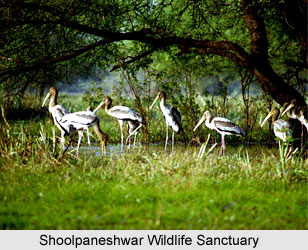
Agriculture provides the maximum prospect to generate sustainable livelihood and employment for the villagers. Industry sectors such as textiles, food products, wood and rubber products and repair and servicing are the supporting pillars of the district financial system. The district is a home to some of the major tourist destinations such as, Shoolpaneshwar Wildlife Sanctuary and Temple and Rajwant Palace, which accounts for a healthy influx of tourists. Narmada houses Herbal Botanical Garden, consisting of almost seventy species of herbal plants, which are used for the Ayurvedic and natural therapy of treatment, and also helps in increasing medical value travel in the district.
Tourism in Narmada District
 Tourism in Narmada District is a marvelous fusion of numerous ecological spots as well as significant pilgrimage centers which are visited by millions of tourists throughout the year. Narmada District is renowned for the presence of Narmada River and various temples which are based on its banks. One can pay a visit to the different wildlife sanctuaries like Shoolpaneshwar Wildlife Sanctuary and Ratanmahal Sloth Bear Sanctuary, coupled with many ecological campsites including Kanjeta Eco Campsite, Sagai Malsamot Eco Campsite, Vishal Khadi Eco Campsite and so on.
Pilgrimage Tourism in Narmada District
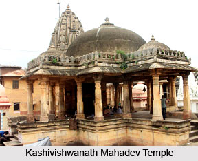
Several temples are located at the intersection of Saraswati River, Orsang and Narmada River. Kashivishwanath Mahadev Temple, Kabir Temple, Shuklatirth Shiva Temple and Nareshwar Temple are some of the reputed temples here. It is believed that taking a dip in the sacred waters of the local rivers purify man from his sins. Impressive wall paintings are existent on the walls of the Kashivishwanath Mahadev Temple. The Surpaneshwar Shiva Temple situated about 5 km from Bharuch and flanked by lush forests of South Gujarat is another famous temple in Narmada District. Nizamshah Dargah, and Dashavatar Ranchhodrai Temple are also popular regional temples.
Nature Tourism in Narmada District
Wildlife lovers can indulge in exciting adventures, thanks to the presence of Shoolpaneshwar Wildlife Sanctuary and Ratanmahal Wildlife Sanctuary, in Dediapada Range. Camping and trekking options are available in the dense forests here. One will be greeted by numerable species of flora and fauna in this ecological site which consists of hyenas, racket tailed drongos, panthers, porcupines, civets, black headed oriole, reptiles and other beasts at Ratanmahal Sanctuary, Kanjeta Eco Site. Above 550 floral species and wildlife species exist at Shoolpaneshwar. Sagai-Malsamot Eco Campsite, Zarwani Eco Campsite and Vishal Khadi Campsite are also important nature tourism locales located here.
Leisure Tourism in Narmada District
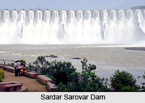
Visitors often visit Rajwant Palace, which was built during 1910 and houses a heritage hotel and a royal museum and also Vadia Palace. An interesting tourist attraction based here is the Sardar Sarovar Dam which is present about 27 km from Rajpipla and is known to be the largest dam on Narmada River, with a height measuring 128 metres. This beautiful dam is responsible for protecting against floods, providing hydropower and water for the purpose of irrigation and also drinking water supply. Situated near the dam is a lake where visitors can try boating.
Anthropological sites along Narmada
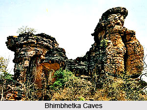 The extensive caves of Bhimbhetka are located in a dyke structure of the Narmada valley at about 45 km northeast of Bhopal. These caves lie between Bhopal and Hoshangabad highway and depict pre-historic rock shelter paintings. These paintings are considered a priceless chronicle in the history of man, which are sculpted on the summit of the Vindhyan heights. The caves of Bhimbhetka were discovered in 1957-58 and is a natural art gallery and an archaeological treasure. This site is considered as one of the oldest human habitation in India where the caves feature house rock paintings. These were formed as early as about 15,000 years ago in vibrant and panoramic detail. The rock paintings here are creations of gradual progress and various adaptations that the primitive man was making in his lifestyle. It is also considered as a World Heritage site.
Bhimbhetka credits its name to the characters of the longest classic in the world, the Mahabharata. It is believed that when the five brothers, called Pandavas, were exiled from their kingdom, they came here and inhabited these caves, the massive rocks seating the massive frame of Bhima, the second Pandava. Further facts support this theory, the resemblance in names of the nearby places and caves are found with the names of the Pandavas.
How to reach Narmada District
By Air:
Nearest airports to Narmada district are in Surat and Vadodara.
By Road:
Major state roads connects Narmada with key industrial centres in the State: Ahmedabad (195 km), Rajkot (357 km), Jamnagar (467 km), Ankleshwar (75 km), Bhavnagar (357 km), Mehsana (269 km), Surat (83 km), Gandhinagar (223 km) and Vapi ( 150 km).
By Rail:
There are four railway stations in Narmada district.


