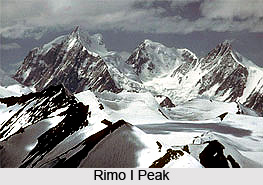
 Rimo I Peak is the world`s 71st highest mountain peak and is the chief summit of the Rimo massif. Rimo massif comprises of four peaks and shares the name Rimo. Rimo I is positioned at a height of 7,385 meters (24,229 feet) above mean sea level. Rimo II is a sub peak on the north ridge of Rimo I and is positioned at a height of 7,373 meters (24,189 feet). Rimo III at a height of 7,233 meters and Rimo IV at a height of 7,169 meters are independent peaks which are nestled in the north of Rimo I.
Etymology of Rimo
The literal meaning of Rimo is `striped mountain`.
Location of Rimo I Peak
It is located in the northern part of the remote Rimo Muztagh which is a sub range of the Karakoram Range in India. It is situated at a distance of twenty kilometres in the northeast of the snout of the Siachen Glacier.
On the north side of the massif there is the Rimo Glacier, on the east side of the massif there is the South Rimo Glacier and the smaller North Terong Glacier on the west side. The mountain prominence (it is a measure of vertical separation between mountains) of the peak is 1,438 meters (4718 feet). The geographic coordinates of the mountain are 35 degree 2121 North, 77 degree 2205 East.
Climbing History of Rimo I Peak
Since the location of the peak is remote it was little known among the people. In the years 1914 and 1929, the area was visited by some explorers namely Filippo de Filippi and Philip and Jenny Visser. The first and so far only, scaling of Rimo I came in the year 1988 by an Indian plus Japanese team led by Hukam Singh and Yoshio Ogata.
This article is a stub. You can enrich by adding more information to it. Send your Write Up to content@indianetzone.com


