Shimsha River
|
The Shimsha River is one of the tributaries of the Cauvery River with a total catchment area of about 8,469 square kilom
|
|
|
One of the tributaries of the Cauvery River is the Shimsha River that flows in southern part of India. The river originates in the southern part of the Devarayanadurga hill at an average elevation of 914 metres, which is located in the Tumkur district of Karnataka. The total length of the river is two hundred and twenty one kilometers and has a catchment area of about 8,469 square kilometers. Maddur is a major city that lies on the bank of the Shimsha River.
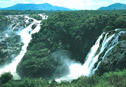 After rising from the Tumkur district, the river starts flowing in the southern direction and enters the Mandya district. In the Mandya district the river flows in the southeast and forms a waterfall at Shimshapura in Malavalli taluk. From Shimshapura it reaches the border of Chamarajanagar district where it merges with the Cauvery River. The meeting of the Shimsha River with Cauvery occurs near the Shivanasamudra falls. Several small streams like Veeravaishnavi, Kanihalla, Chickkhole, Hebbahalla, Mullahalla and Kanva join the Shimsha River during it course. After rising from the Tumkur district, the river starts flowing in the southern direction and enters the Mandya district. In the Mandya district the river flows in the southeast and forms a waterfall at Shimshapura in Malavalli taluk. From Shimshapura it reaches the border of Chamarajanagar district where it merges with the Cauvery River. The meeting of the Shimsha River with Cauvery occurs near the Shivanasamudra falls. Several small streams like Veeravaishnavi, Kanihalla, Chickkhole, Hebbahalla, Mullahalla and Kanva join the Shimsha River during it course.
A beautiful sprawling dam is built across the Shimsha River in Igglur. At Shimshapura where the Shimsa River forms a waterfall there is the Shimsha Hydro electric Project.
|
|
|
|


