 Muthupet is a panchayat town located in Tiruvarur district of the southern state of India, Tamil Nadu.
Location of Muthupet
Muthupet is located in the southern tip of the Kaveri River delta next to the Bay of Bengal.
Geography of Muthupet
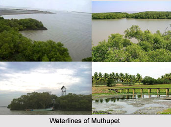
The Korayar River flows in the east of Muthupet and the Bamaniyar River flows in the west. The two rivers join near Muthupet and form a lagoon, which contains a variety of fish. Located about 400 km. from Chennai, Thirutturaipoondi and Vedaranyam are situated in the vicinity.
Demography of Muthupet
According to the Population report in the year 2011, Muthupet had a population of 17,313. Males constitute 47% of the population and females` account for the remaining 53%. In Muthupet, 12% of the population is less than six years of age.
Education of Muthupet
The average literacy rate of Muthupet is 71%, which is higher than the national average literacy rate of 59.5%. Out of it, the male literacy rate is 78% and the female literacy rate is 65%.
Tourism in Muthupet
The lagoon in Muthupet makes it an ideal place for fishing, pearl hunting and bird hunting. It is well known for its fin fishes, shrimps and crabs. Muthupet is embellished with many mosques, which includes Jumma (Kuthba) Mosque, New Mosque, Azath Nagar Mohideen Mosque, Darga Shariff Mosque, Makkah Mosque, Madhina Mosque, Arab Sahib Mosque, Kuttiyar Mosque, Mohideen Mosque, Pettai Mohideen Mosque, Jamia Mosque and Noor Mosque.
Visiting Information
The nearest railway station is the Muthupet Railway Station on the Karaikkudi - Tiruturaipundi line. Regular bus services also connect the town with the cities of Thanjavur, Mannargudi and Tiruvarur.
Muthupet
Muthupet is a panchayat town famous for fishing and it has many tourist locations.


