 Geography of Shivpuri district comprises of 18139 hectares of forest area and the total geographical area is 10298 square kilometers. The district of Shivpuri in the state of Madhya Pradesh shares its borders with Morena district, Gwalior district and Datia district to the North, Jhansi district of Uttar Pradesh state to the East, Kota district of Rajasthan state to the West and the Guna district to the South. The district headquarters of Shivpuri is situated on the national Highway number three (Agra-Bombay National Highway) about one hundred and thirteen kilometers from Gwalior and about ninety eight kilometers from Guna. This district of the state of Madhya Pradesh is mostly laid out over small hill tops covered with deciduous forests where the slope is gentle with verdant vegetation and good forests round about, the landscape is generally pleasing.
The district of Shivpuri in Madhya Pradesh spreads over an area of 10298 square kilometers, while the total area under cultivation is 409264 square kilometers and the area covered by forest is 18139 hectares. The Shivpuri district is situated in between twenty four degree six minutes and twenty five degree six minutes to the North latitude and seventy seven degree and seventy eight degree four minutes to the East longitude. The district is situated 521.5 meters above sea level.
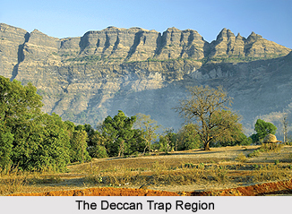 The Shivpuri district can be bifurcated into three main divisions based on its geology. The Bundelkhand trap consist mainly Pre-Dharwarian granites, which consists of sparsely cultivated uplands and shallow valley. It covers eastern half of the district with an area of one thousand five hundred and thirty nine square miles approximately. The Deccan Traps mainly comprises of undulating plains and flat topped ranges of the hill. It covers an area of four hundred and twenty six square miles towards the southern parts of the district viz.- towards Bhadarwas, Barokra Laterite and Aluminum are also found in the region and cover an area of 374.80 square miles. In the Upper Vindhyas, sandstones of Kaimur Rewa and Bhander are commonly found in this region. The dips are very shallow and it suggests that there has been a very less disturbance since Vindhyan period and this region occupies the western half of the district.
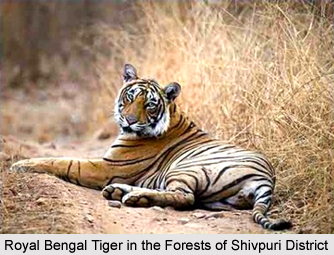
The climate of the district of Shivpuri is cool and dry. The hot weather condition starts from about the middle of the month of April and lasts up to mid of May. The temperature in the month of June touches forty two degree Celsius and by the end of June or by the first week of July, the monsoon breaks and weather becomes cool. The Shivpuri district receives its rains from the Arabian Sea. The rainy season is over generally by the end of September and the district receives and average rainfall of 875 mm. There are different species of trees commonly found in the district which include Khair, Dhow, Kardhai, Salaj, Palas, Tendu, Mahua, Karey, Karch, Saja, Koha, Saj.Dhaman Kaim, Tinach, Semal, Amaltas and Jamun tree. Wildlife has been steadily declining in the district, due to indiscriminate shooting and cutting of forests. In ancient times the forests were thick and a good number of animals could be seen. The district has a national park where a good number of animals can be seen.


