 Dharmapuri District is situated in the southern state of Tamil Nadu. Dharmapuri District has a population of 2,856,300 according to the 2001 census report. Dharmapuri is the district headquarters. After independence, Dharmapuri was a part of the Salem District. Krishnagiri District which was previously a part of Dharmapuri district became a separate district in 2004. The main languages spoken in the district are Tamil, Kannada language, Telegu language and Urdu language.
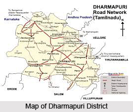
Dharmapuri District
Dharmapuri District is located in Tamil Nadu and is well known for its mango cultivation. Dharmapuri District was formed as a separate district on 2nd of October, 1965 with its headquarters at Dharmapuri.
Introduction
History of Dharmapuri District
The earliest known chieftain, who ruled Tagadur (present Dharmapuri) during the Sangam era, is Adigaman Naduman Anji, whose patronage sustained the famous poetess Avvaiyar. The Western Gangas are also mentioned as having ruled Baramahal during the end of the 8th century. The last Mysore war in 1799 added up several places in Hosur Taluk like Nilgiri, Anjetti, Durgam, Ratnagiri and Kelamangalam which were recaptured by British. After the fall of Srirangapattinam in which Tipu Sultan lost his life, the Balaghat area was also added to Salem District. The present Dharmapuri District was then a part of the Salem district. During the British rule in the country and even till 1947 Dharmapuri was one of the Taluks of Salem District. Dharmapuri District was formed on 2nd October, 1965 with its headquarters at Dharmapuri. Dharmapuri District was bifurcated into Dharmapuri and Krishnagiri districts on 9th September, 2004.
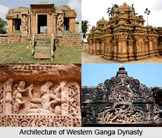
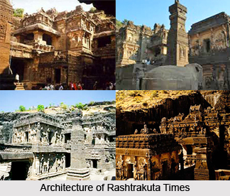 History of Dharmapuri district dates back to the ancient Western Ganges dynasty and later this district became flourished during the time of Rashtrakutas in 9th Century.The earliest known chief or leader who ruled Tagadur i.e. present Dharmapuri is Adigaman Naduman Anji. He ruled during the Sangam era. In the 8th century the northern parts of Salem District were under the Pallavas regime. The Western Gangas are mentioned as having ruled Baramahal during the end of the 8th century.
In the beginning of 9th Century, the Rashtrakutas gained power and influenced the history of the district. It continues till the next two centuries. During this period, the other happenings were like this. The Cholas rose to power in the south and Aditya-I conquered the Kongunadu in 894 A.D. During 949-950 A.D., the Cholas suffered a defeat from the Rastrakuttas whose decline started later after the death of their king Krishna-III. Subsequently, the entire area in Salem District came under the rule of the Cholas. The Gangavadi was then took over to the Chola territory and placed in charge of an Adigaman Tagadur.
In the 12th century the decline of the Chola Empire took place when the Hoysalas rose to power and routed the Cholas from Gangavadi. They are said to have captured Kolar, sacked Kotayur and over ran the western parts of Kongunadu as well. The Baramahal and Talaget areas still remained with the Cholas.
The history of the 13th Century experiences the changes between the Hoysalas and the Pandyas. This portion may be added after when the Yadavas attacked them from the North. The Hoysalas retreated towards the South in Kongunadu. It is known that Jatavarman Soundrapandian-I assisted the Yadavas in driving out the Hoysalas king named Vira Someswara. He was from the Chola territory.
In the 14th century the rise of Vijayanagar kingdom was prominent. In 1365-66 A.D., Bukka-I turned his attention towards the south to overthrow the Mohammedan Sultanate of Madurai. One of these campaigns must have brought Salem District under the Vijayanagar kings. They ruled these parts till 1565 A.D. Meanwhile the ascendancy of the Madurai Nayakas reached its zenith during the time of Tirumala Nayak who came to power in 1623 A.D. Ramachandra Nayaka, one of his poligars was incharge of Talaimalai. This was a hill overlooking the Cauvery in the south Namakkal taluk. The Namakkal Fort is said to have been built by them. The Gathi Mudaliars were incharge of the most dangerously exposed province of the Nayak Kingdom with Kaveripuram on the right bank of the Cauvery. Their strategic capital beginning from the principal passes to the Mysore plateau.
Kantirave Narasa Raja of Srirangapatinam took several places in Coimbatore from Gathi Mudaliars in 1611 A.D. After 11 years, of this happening he seized Baramahal including Viralahadradurg, Pennagaram, Dharmapuri and Denkanikotta. In 1654 A.D., he took over Hosur from Chandra Sankar Dodda Devaraju. He was the king of Mysore wrested Omalur from the Gathi Mudaliars and thus erased them out of political scene. The behavior of Marathas however checked the power of the Mysore Kings. For a time Baramahal and Talaghat passed into the hands of Marathas. In 1688-89 A.D., Chikka Deva Raya king of Mysore felt strong enough once again to invade Baramahal and wrested Dharmapuri, Manukonda, Omalur Paramathi, Kaveripatinam and Attur. Chika Deva Raya retrieved all these and the whole district of Salem came under his control before his death in 1704 A.D. Meanwhile Abdul Nabikhan of Nawab of Cuddapah extended his possession towards South and by 1714 A.D., he made himself master of the Baramahal.
By about 1750 A.D., Hyder Ali was in power in Mysore Baramahal came under his influence in 1760 A.D. By 1767 A.D., the British Government at Madras planned an attack on Hyder Ali and seized Kaveripattinam without serious opposition. Krishnagiri was attacked at that time. Meanwhile, reinforcement was brought by Hyder Ali and they drove away the British. Thus, Kaveripattinam was recaptured. Some months later the British made another invasion on the Baramahal. Further, South Dharmapuri, Salem, Attur, Sendamangalam and Namakkal were surrendered to the British without serious difficulties. The victory, however, was short-lived because Hyder Ali soon recaptured Dharmapuri, Denkanikota, Omalur, Salem and Namakkal. During the period of second Mysore war, Salem District was under the control of Hyder Ali.
Tippu Sultan succeeded Hyder Ali and proved to be a formidable power. The British made an alliance with the Marattas and the Nizam and started the third Mysore war in 1790 A.D. It happened in order to control the power of Tippu Sultan. A wing of the British forces stationed itself fully reinforced at Kaveripattinam. Even though Tippu Sultan rushed to this spot with his full force, he could not dislodge the British. A number of alternations took place between the commanding forces in the Baramahal area. In 1791, Hosur, Anjetti, Nilgiri and Ratnagiri came under the British Royakotta and many other small forts fell without much resistance. In 1791 Tippu sent a force from the South along the Tippu pass. In the battle at Pennagaram they surrendered to the British. In 1792 A.D., a peace treaty was signed between Tippu and English. According to this, a half of the dominion of Tippu was taken away. The whole of Salem District except the Balaghat and a portion of Hosur came into the hands of the British. The first British Collector had is headquarters at Krishnagiri on strategic consideration as well.
The last Mysore war in 1799 added up several places in Hosur Taluk like Nilgiri, Anjetti, Durgam, Ratnagiri and Kelamangalam, which were recaptured by British. After the fall of Srirangapattinam in which Tippu Sultan lost his life, the Balaghat area was also added to Salem District.
The present Dharmapuri district was then a part of the Salem district. During the British rule in the country and even till 1947 Dharmapuri was one of the Taluks of Salem District. The Dharmapuri district was formed as a separate district on 2nd October 1065. It has its headquarters at Dharmapuri. Thiru G.Thirumal I.A.S was the first Collector of Dharmapuri district. The Dharmapuri district was again bifurcated into Dharmapuri and Krishnagiri districts on 9th February 2004.
History of Dharmapuri district dates back to the ancient Western Ganges dynasty and later this district became flourished during the time of Rashtrakutas in 9th Century.The earliest known chief or leader who ruled Tagadur i.e. present Dharmapuri is Adigaman Naduman Anji. He ruled during the Sangam era. In the 8th century the northern parts of Salem District were under the Pallavas regime. The Western Gangas are mentioned as having ruled Baramahal during the end of the 8th century.
In the beginning of 9th Century, the Rashtrakutas gained power and influenced the history of the district. It continues till the next two centuries. During this period, the other happenings were like this. The Cholas rose to power in the south and Aditya-I conquered the Kongunadu in 894 A.D. During 949-950 A.D., the Cholas suffered a defeat from the Rastrakuttas whose decline started later after the death of their king Krishna-III. Subsequently, the entire area in Salem District came under the rule of the Cholas. The Gangavadi was then took over to the Chola territory and placed in charge of an Adigaman Tagadur.
In the 12th century the decline of the Chola Empire took place when the Hoysalas rose to power and routed the Cholas from Gangavadi. They are said to have captured Kolar, sacked Kotayur and over ran the western parts of Kongunadu as well. The Baramahal and Talaget areas still remained with the Cholas.
The history of the 13th Century experiences the changes between the Hoysalas and the Pandyas. This portion may be added after when the Yadavas attacked them from the North. The Hoysalas retreated towards the South in Kongunadu. It is known that Jatavarman Soundrapandian-I assisted the Yadavas in driving out the Hoysalas king named Vira Someswara. He was from the Chola territory.
In the 14th century the rise of Vijayanagar kingdom was prominent. In 1365-66 A.D., Bukka-I turned his attention towards the south to overthrow the Mohammedan Sultanate of Madurai. One of these campaigns must have brought Salem District under the Vijayanagar kings. They ruled these parts till 1565 A.D. Meanwhile the ascendancy of the Madurai Nayakas reached its zenith during the time of Tirumala Nayak who came to power in 1623 A.D. Ramachandra Nayaka, one of his poligars was incharge of Talaimalai. This was a hill overlooking the Cauvery in the south Namakkal taluk. The Namakkal Fort is said to have been built by them. The Gathi Mudaliars were incharge of the most dangerously exposed province of the Nayak Kingdom with Kaveripuram on the right bank of the Cauvery. Their strategic capital beginning from the principal passes to the Mysore plateau.
Kantirave Narasa Raja of Srirangapatinam took several places in Coimbatore from Gathi Mudaliars in 1611 A.D. After 11 years, of this happening he seized Baramahal including Viralahadradurg, Pennagaram, Dharmapuri and Denkanikotta. In 1654 A.D., he took over Hosur from Chandra Sankar Dodda Devaraju. He was the king of Mysore wrested Omalur from the Gathi Mudaliars and thus erased them out of political scene. The behavior of Marathas however checked the power of the Mysore Kings. For a time Baramahal and Talaghat passed into the hands of Marathas. In 1688-89 A.D., Chikka Deva Raya king of Mysore felt strong enough once again to invade Baramahal and wrested Dharmapuri, Manukonda, Omalur Paramathi, Kaveripatinam and Attur. Chika Deva Raya retrieved all these and the whole district of Salem came under his control before his death in 1704 A.D. Meanwhile Abdul Nabikhan of Nawab of Cuddapah extended his possession towards South and by 1714 A.D., he made himself master of the Baramahal.
By about 1750 A.D., Hyder Ali was in power in Mysore Baramahal came under his influence in 1760 A.D. By 1767 A.D., the British Government at Madras planned an attack on Hyder Ali and seized Kaveripattinam without serious opposition. Krishnagiri was attacked at that time. Meanwhile, reinforcement was brought by Hyder Ali and they drove away the British. Thus, Kaveripattinam was recaptured. Some months later the British made another invasion on the Baramahal. Further, South Dharmapuri, Salem, Attur, Sendamangalam and Namakkal were surrendered to the British without serious difficulties. The victory, however, was short-lived because Hyder Ali soon recaptured Dharmapuri, Denkanikota, Omalur, Salem and Namakkal. During the period of second Mysore war, Salem District was under the control of Hyder Ali.
Tippu Sultan succeeded Hyder Ali and proved to be a formidable power. The British made an alliance with the Marattas and the Nizam and started the third Mysore war in 1790 A.D. It happened in order to control the power of Tippu Sultan. A wing of the British forces stationed itself fully reinforced at Kaveripattinam. Even though Tippu Sultan rushed to this spot with his full force, he could not dislodge the British. A number of alternations took place between the commanding forces in the Baramahal area. In 1791, Hosur, Anjetti, Nilgiri and Ratnagiri came under the British Royakotta and many other small forts fell without much resistance. In 1791 Tippu sent a force from the South along the Tippu pass. In the battle at Pennagaram they surrendered to the British. In 1792 A.D., a peace treaty was signed between Tippu and English. According to this, a half of the dominion of Tippu was taken away. The whole of Salem District except the Balaghat and a portion of Hosur came into the hands of the British. The first British Collector had is headquarters at Krishnagiri on strategic consideration as well.
The last Mysore war in 1799 added up several places in Hosur Taluk like Nilgiri, Anjetti, Durgam, Ratnagiri and Kelamangalam, which were recaptured by British. After the fall of Srirangapattinam in which Tippu Sultan lost his life, the Balaghat area was also added to Salem District.
The present Dharmapuri district was then a part of the Salem district. During the British rule in the country and even till 1947 Dharmapuri was one of the Taluks of Salem District. The Dharmapuri district was formed as a separate district on 2nd October 1065. It has its headquarters at Dharmapuri. Thiru G.Thirumal I.A.S was the first Collector of Dharmapuri district. The Dharmapuri district was again bifurcated into Dharmapuri and Krishnagiri districts on 9th February 2004.
Geography of Dharmapuri District
The climate of the Dharmapuri District is generally warm. The climate of the district is generally warm and the temperature varies from 12 degree Celsius to 35 degree
 Celsius and receives an annual rainfall of 80 cm. The hottest period of the year is generally from the months of March to May, the highest temperature going up to 38 degree Celsius in April. The climate becomes cool in December and continuous so up to February, touching a minimum of 17 degree Celsius in January. On an average Dharmapuri District receives an annual rainfall of 895.56 mm. The soil type ranges from black to mixed loam; Red sandy soils are seen in Harur Taluk. Black and loam soil are found in Dharmapuri Taluk. Generally, the soil is low in Nitrogen and Phosphate content with no marked variation between Taluks. The district is rich in mineral deposit like apatite, copper, corundum, gold, iron, limestone, magnetite, nickel, quartz, vermiculite, black granite and grey granite.
 Geography of Dharmapuri district is prone to draught and therefore the draught resistant fruits crops are mainly grown in this district. The district of Dharmapuri came into existence from the 2nd of October 1965, and it is located to the north-western corner of the state of Tamil Nadu and is bounded by the district of Tiruvannamalai and Villupuram to the east, Salem district to the South, Krishnagiri district to the north and Kaveri River to the west. The Dharmapuri district is situated between eleven degree and forty seven minutes and twelve degree and thirty three minutes North latitudes and Seventy seven degree two minutes and seventy eight degree forty minutes East longitudes. The total geographical area of the district of Dharmapuri is 4497.77 square kilometers, which is about 3.46 percent of the state of Tamil Nadu.
The climatic condition of this district in the state of Tamil Nadu is generally warm. The hottest period of the year in this district usually falls from the months of March to May and the highest temperature in the Dharmapuri district goes up to thirty eight degree centigrade in the month of April. The climate in this district of the Tamil Nadu state gets cooler in the month of December and it continues so up to the month of February by getting down to a minimum of seventeen degree centigrade in the month of January. The average annual rainfall received by the district of Dharmapuri is 895.56 mm.
The type of soil in this district ranges from black to mixed loam. Red sandy soils are also seen in the Harur taluk. Black and loam soil are there in the Dharmapuri taluk. The soil is generally low in Phosphate and Nitrogen content with no marked variation between taluks. The economy of Dharmapuri district economy is largely agrarian and about seventy percent of the workforce is dependent on agriculture and allied activities. This district is having a sufficient reserve of granite. Good quality black granite is available in Pennagaram, Harur and Palacode blocks of the district. The district of Dharmapuri is usually prone to draught and for this reason several drought resistant perennial crops are grown in this district.
Celsius and receives an annual rainfall of 80 cm. The hottest period of the year is generally from the months of March to May, the highest temperature going up to 38 degree Celsius in April. The climate becomes cool in December and continuous so up to February, touching a minimum of 17 degree Celsius in January. On an average Dharmapuri District receives an annual rainfall of 895.56 mm. The soil type ranges from black to mixed loam; Red sandy soils are seen in Harur Taluk. Black and loam soil are found in Dharmapuri Taluk. Generally, the soil is low in Nitrogen and Phosphate content with no marked variation between Taluks. The district is rich in mineral deposit like apatite, copper, corundum, gold, iron, limestone, magnetite, nickel, quartz, vermiculite, black granite and grey granite.
Geography of Dharmapuri district is prone to draught and therefore the draught resistant fruits crops are mainly grown in this district. The district of Dharmapuri came into existence from the 2nd of October 1965, and it is located to the north-western corner of the state of Tamil Nadu and is bounded by the district of Tiruvannamalai and Villupuram to the east, Salem district to the South, Krishnagiri district to the north and Kaveri River to the west. The Dharmapuri district is situated between eleven degree and forty seven minutes and twelve degree and thirty three minutes North latitudes and Seventy seven degree two minutes and seventy eight degree forty minutes East longitudes. The total geographical area of the district of Dharmapuri is 4497.77 square kilometers, which is about 3.46 percent of the state of Tamil Nadu.
The climatic condition of this district in the state of Tamil Nadu is generally warm. The hottest period of the year in this district usually falls from the months of March to May and the highest temperature in the Dharmapuri district goes up to thirty eight degree centigrade in the month of April. The climate in this district of the Tamil Nadu state gets cooler in the month of December and it continues so up to the month of February by getting down to a minimum of seventeen degree centigrade in the month of January. The average annual rainfall received by the district of Dharmapuri is 895.56 mm.
The type of soil in this district ranges from black to mixed loam. Red sandy soils are also seen in the Harur taluk. Black and loam soil are there in the Dharmapuri taluk. The soil is generally low in Phosphate and Nitrogen content with no marked variation between taluks. The economy of Dharmapuri district economy is largely agrarian and about seventy percent of the workforce is dependent on agriculture and allied activities. This district is having a sufficient reserve of granite. Good quality black granite is available in Pennagaram, Harur and Palacode blocks of the district. The district of Dharmapuri is usually prone to draught and for this reason several drought resistant perennial crops are grown in this district.
Culture of Dharmapuri District
The inhabitants of Dharmapuri District speak different languages. The predominant communities found in this area are the Kapus, Lingayaths, Okkaligas, Baliya Chetties, Oddars and Scheduled Castes like Holeyas and Madigas. The weavers of this area mostly belong to Sali Chetties. The Baramahal area comprising eastern part of Dharmapuri taluk constitutes Telugu and Tamil speaking communities, majority of whom belong to Vanniars. Among the Scheduled Caste population Adi-Dravidars and Arunthathiars form major share scattered throughout the district.
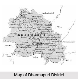
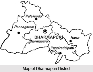
Location of Dharmapuri District
The total geographical area of Dharmapuri District is 4497.77 sq kms that is 3.46 percent of the total area of Tamil Nadu. Dharmapuri district is situated in the north western corner of Tamil Nadu and is bounded by Tiruvannamalai District and Vellore District on the east, Salem District on the South,
 Krishnagiri District on the north and Kaveri River on the west. It is located between north latitude 11 degree 47 minutes and 12 degree 33 minutes and east longitudes 77 degree 2 minutes and 78 degree 40 minutes.
Krishnagiri District on the north and Kaveri River on the west. It is located between north latitude 11 degree 47 minutes and 12 degree 33 minutes and east longitudes 77 degree 2 minutes and 78 degree 40 minutes.Tourism in Dharmapuri District
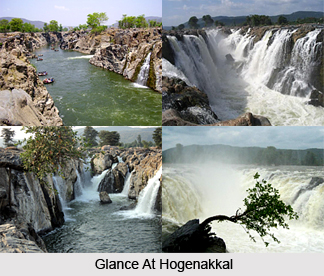
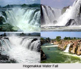
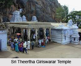 Dharmapuri District is widely known for its tourist spots. It is one of the renowned tourist destinations of Tamil Nadu. People from far and wide come and explore the places of interest offered by Dharmapuri District. The district is also an ideal tourist destination in the state. Some of the attractions of Dharmapuri district are Hogenakkal Falls, Adhiyamankottam, Subramanya Siva Memorial at Papparapatti, Rajaji Memorial at Thorapalli, Krishhnagiri Dam and the Theerthagirishwarar Temple at Theerthamalai. Hogenakal is situated at the borders of Karnataka at 46 kms from Dharmapuri and is one of the main tourist spots of the district. Theerthamalai is an important sacred place in Harur taluk of Dharmapuri District. All these places are worth visiting.
A number of industries are also located here. The district is also the largest producer of mango and accounts for one half of the mango yield in the state. Dharmapuri District is the second largest producer of tomato and accounts for 22 percent of the total area of the state.
 Tourism in Dharmapuri district provides a suitable opportunity for a tour of the district in the state of Tamil Nadu. There are several places of attraction in this district including Hogenakal, Theerthamalai, Adhiyamankottam, etc. A number of historical monuments are also present in the Dharmapuri district which is worth a visit. Subramanya Siva Memorial at Papparapatti is a monument erected in memory of the great patriot Subramanya Siva in his samadhi near Papparapatti, Pennagaram Taluk.
The capital of Adhiyamans, ancient rulers of Tagadur, was Adhiyamankottam which is located on the Salem-Dharmapuri road at a distance of seven kilometers from Dharmapuri. The ruin of the roughly oval shaped fort still remains in the district. The Chenraya Perumal temple is the biggest of the lot which is held as a protected monument which and it is believed to have been constructed both by the king Krishna Deva Raya and the kings of the Hoysala Empire. There is a mandapam which leads to the sanctum sanctorium. There are paintings in the ceiling depicting scenes from the Mahabharata, Viswarupa dharshan of Lord Krishna and some scenes from Ramayana. All the paintings date back to the thirteenth century.
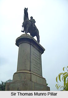 Sir Thomas Munro Pillar at Dharmapuri district is another tourist attraction. This pillar was erected by the government of Chennai (Madras) in order to mark the association of Dharmapuri with Sir Thomas Munro who lived in the district from April 1792 to the month of March 1799, as Assistant to the Superintendent of Revenue in the Baramahal. The house where Munro lived and his favourite garden where few yards away from this place in the Dharmapuri district.
One of the well-known tourist destinations in this district is Hogenakal. It is located at the borders of Karnataka, at forty six kilometers from Dharmapuri. In Hogenakal, the Kaveri River enters into the state of Tamil Nadu as a big river with gushing water and presents a natural fall. The name Hogenakal is derived from Kannada which means, `Smoky Rocks`. The river when falls on the rock below with its gushing water resembles a smoke emanating from the rocks. At Hogenakal the water spreads for miles around and on these waters cruising on country made dinghies or Parisal is possible. Parisal ride gives an enthralling experience. Surrounded by hills at various heights, Hogenakal presents totally a very different ambience and refreshing relaxations to its visitors. One could take bath in the falls, can avail oil massaging by local people, etc. As the river flows throughout the year, Hogenakal can be visited all days through the year. There is enough transport facility available from Dharmapuri and Krishnagiri.
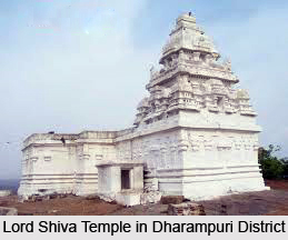
Another major tourist destination in the district of Dharmapuri is Theerthamalai. It is an important sacred place in Harur taluk of Dharmapuri District. Shri Theerthagirishwarar temple is situated at the top of a hillock. The Vijayanagara and the Chola Kings donated liberally to this temple. A lot of devotees throng the temple during the Mahashivarathiri. For the benefit of the devotees visiting this place, the Department of Tourism has constructed a Guest Houses close to the temple. The place has also been declared as a major tourist spot in Dharmapuri District.
Economy of Dharmapuri District
 Economy of Dharmapuri district is mainly agrarian in nature. Almost seventy percent of the workforce is dependent on agriculture and allied activities. The district is one among most backward and drought prone area in the Tamil Nadu state. The climate of this district is generally warm. The hottest period of the year in this district is generally from the months of March to May, the highest temperature here goes up to about thirty eight degree centigrade in the month of April. The climate gets cooler in the month of December and continuous to be so till February, getting to a low of about seventeen degree centigrade in the month of January. The average annual rainfall in this district is 895.56 mm. The type of soil in this district ranges from black to mixed loam. Red sandy soils are seen in the Harur Taluk while Black and loam soil are there in the Dharmapuri Taluk. Generally the soil is low in Nitrogen and Phosphate content with no marked variation between Taluks.
The district of Dharmapuri forms a major horticultural belt in Tamil Nadu. As the area is prone to the devastating effects of draught, it has become essential to switch over to cultivation of drought tolerant perennial fruit crops in this district. Mango is the main horticulture crop of this district. It has the highest area under the fruit crops. The district accounts for about one-third area under mango and almost one-half of the mango yield in the state. Palacode is the main area where tomato is cultivated and Chilli is cultivated mainly at Pennagaram.
Since Dharmapuri is an inland district, fishing is restricted to inland waters. A large variety of fishes are available which include katla, rogu, mirgal, common and corp. This district of the state of Tamil Nadu in India is endowed with sizeable reserves of granite. Top quality black granite is available in Harur, Pennagaram and Palacode blocks. Quartz is there at Kendiganapalli Village of Pennagaram taluk, A.Velampatti of Harur taluk and Pethathampatti of Pappireddipatti taluk. Malibdinum is another high quality mineral available at Harur in Dharmapuri district, which is identified as a good conductor.
Recently updated articles in States of India

History of Thissur District
Early History of Thissur District explains flourishing of the port cities. Now these port cities are transformed into archaeological sites.

Tippi Orchid Research Centre, Arunachal Pradesh
Tippi Orchid Research Centre in Arunachal Pradesh is renowned for its rich collection of exotic and endangered orchids. Surrounded by lush rainforest...

Tourism in Nashik District
Pilgrimage tourism in Nashik district involves visiting the various places of Hindu and Jain worship located here. Some of the holiest sites for Hind...

Mangadu, Kerala
Mangadu in Kerala’s Kollam district is a significant megalithic site known for its urn burials, cist burials, menhirs, and stone circles. Excavations...

Devaswom
History of Devaswom is not very ancient and can be dated back to late seventeenth century.
Related articles in States of India

East Indian States
East Indian States comprises of Bihar, Jharkhand, West Bengal, Odisha and also the Union Territory of Andaman and Nicobar Islands. It defines the cult...

Purnia District in Bihar
Purnia District is located in Bihar and extends from River Ganga to Nepal. The district has a rich Hindu history and glorious past.

Hooghly district
Hooghly District along the bank of the river Hooghly is one of the principal trading ports of West Bengal.

Geography Of Chittoor District
Geography of Chittoor district is spread along the topography of the land which is divided into two natural divisions; Chittoor has a dry and healthy...

Districts of West Bihar
Districts of West Bihar is comprised of medieval monuments that were built by the different governors of Mughal era.