 Rivers are flowing bodies of waters. There are rivers on every corner of this whole world. Rivers are an important part of the Earth`s water cycle and the sculpting of the Earth`s topography as they carry huge quantities of water from the land to the sea. This district also has a network of rivers, canals and backwaters. Manimala, Pamba and Achankovil are the names of some of the major rivers.
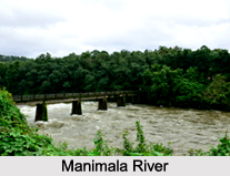
Manimala River:
The river Manimala originates from Mothavara hills in Kottayam district and enters the district at Thalavadi village in Kuttanad taluk, while it passes through Edathua and Champakulam villages and joins the Pamba River at Muttar. The villages, which lie in the course of the river Manimala, are Manimala, Mallappally, Kaviyoor, Kalloppara, Thalavadi, Kozhimukku and Champakkulam respectively. It has a length of 91.73 Km and drainage area of 802.90 Km
Pamba River:
Pamba which is the third longest river in Kerala is formed by several streams originating from Peerumedu plateau in Idukki district while enters Alappuzha district at Chengannur it flows through Pandanad, Veeyapuram, Thakazhy, and Champakulam through a distance about 177.08 Km and plunges into vembanad lake through several branches such as Pallathuruthi Ar, Nedumudi Ar and Muttar. The river has a length of 117 Km and is navigable to a length of 73 Km.. The catchments area of this river is 1987.17 Sq.Km whereas the main tributaries of the river are Pambayar, Kakki Ar, Arudai Ar, kakkad Ar and Kallar.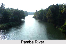
Achankovil River:
This Achankovil River is often known as Kulallada River. It originates from Pasukida mettu, Ramakkal Theri and Rishimalai of Kollam district and enters the district at Venmony.
It has a catchments area of 1155.14 Sq.Kms and a marginable length of 32.19 Km. It passes through Cheriyanad, Puliyoor and Chengannur villages while enters Mavelikkara Taluk at Chennithala it flows through Thriperumthura and pallippad villages and joins Pamba at Veeyapuram in the same manner.
Back Waters.
Vembanad Lake:
The Vembanad Lake is the most important of the west coast canal system. Its length is 84 Km, breadth is 3.1 Km, an area is 204 Sq.Km. Stretching from Alappuzha to Kochi its Borders are Cherthala, Ambalapuzha and Kuttanad Taluks of Alappuzha district, Kottayam, vaikom and Changanasserry taluks of Kottayam district and Kochi and Kanayannur Taluks of Ernakulam district.
Pamba, Achankovil, Manimala, Meenachil and Muvattupuzha rivers discharge into this lake. Pathiramanal Island, which is popularly known as the mysterious sand of midnight with lots of coconut palms and luxuriant vegetation and also Kayamkulam Lake is situated in the centre of this Vembanad Lake. Perumbalam and Pallippuram are the other two islands that are situated in this lake. The Thannermukkom regulator constructed across Vembanad Lake between Thannermukkom and Vechur is intended to prevent tidal action and intrusion of saline water into the lake. It is the largest mud regulator in India.
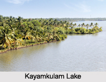 Kayamkulam Lake:
This Kayamkulam lake is a shallow lake stretching between Panmana and Karthikappally. This has an outlet to sea at Kayamkulam barrage. This lake has an area of 59.57 Sq.Km., a length of 30.5 Km and an average breadth of 2.4 Km. It connects Ashtamudi lake by the Chavara Panmana canal.
Canals:
Alappuzha has a network of canals enclosed in the west coast canal system, which are used for navigation. The important canals are Vadai canal and the Commercial canals. The other one is Link canal, which is found in between these two canals. Apart from these, there are many inland canals, which are mainly used for passenger navigation and commercial purposes.
The lakes are mainly used for inland water transport of passengers and cargo. Inland fisheries have also been flourished in these regions.
Sea Coast:
Alappuzha has a flat unbroken seacoast of 82 Km lengths, which is almost 13.9 % of the total coastal line of the state. During the month of June an interesting phenomenon happens in this seacoast that is the periodic shifting of mud bank popularly known as "Chakara" within a range of 25 Km in Alappuzha-Purakkad coast. This happens due to hydraulic pressure when the level of backwater rises during southwest monsoon.


