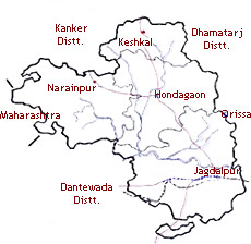
The Bastar Division is an administrative division of Chhattisgarh state in the central part of the Indian subcontinent. It incorporates the districts of Bastar, Dantewada, and Kanker. Bastar Division came into being in 1999, when the bigger Bastar District was divided into the current districts of Bastar, Dantewada, and Kanker.
In 2000 the division was included under the state of Chhattisgarh. The Bastar District has its district headquarters in Jagdalpur. The district covers an area of 8755.79 square km. As boundaries it has the Rajnandgaon District on the northwest, the Kanker District on the north, the Dhamtari District on the northeast, the Navarangpur and the Koraput districts of the state of Orissa on the east, the Dantewada District on the south and southeast, and the Gadchiroli District of the state of Maharashtra on the east.  The district headquarters of the Dantewada District are in Dantewada. The district covers an area of 10,238.99 square km and has a total population of 719,065 (as per the 2001 census). The district has four tehsils, namely Bijapur, Bhopalpatnam, Dantewada, and Konta. It is surrounded by the Bastar District on the north and northeast, the Malkangiri District of the state of Orissa and the Indravati River on the east and the Khammam District of the state of Andhra Pradesh on the south and southwest. The Kanker District is positioned in the southern section of the state of Chhattisgarh between the longitudes 20.6- 20.24 and latitudes 80.48- 81.48. The district covers a total area of 5285.01 square kilometers. The district has many places of tourist attraction. Some of these are the Malanjhkudum Water fall, the Charre- Marre Water fall, the Gadiya Mountain and the Shivani Maa temple.


