 Geography of Fatehabad District comprises part of the alluvial or Ghaggar-Yamuna plain and its southern and western portions mark a gradual transition to Thar Desert in India. Geographic pattern of the district owes its existence to geomorphic processes having closer affinity with the climatic aridity, both of the recent and past geologic periods. Throughout almost the entire district the dominant feature of topography is the occurrence of Aeolian sand of variable shape and thickness overlying the Pleistocene alluvium which becomes fewer as the eastern border of the district is approached. The only variation from this description is found in the north, a tract locally known as Nali. The mean attitude varies between 210 metres and 220 metres and it generally slopes from north-east to south-west.
Fatehabad District can be sub-divided into three topographic units - Sub-Recent alluvial plain, Late Quaternary to Sub-Recent sand dune areas and Plain with sand dunes. The plain locally known as Nali occurs principally as floodplain sediments along the courses of the Ghaggar River. It is gently sloping, trending northeast to south-west in Tohana and Fatehabad tehsils. The sand dune areas can be classified into conspicuous topographic units having different genetic types of sand dunes such as active, semi-active and fossil or fixed. The active and moving sand dune generally occurs along the western fringe of Fatehabad District where the mean annual rainfall varies between 200 to 250 mm.
Active sand dunes vary from uneven sand cover, sand hummocks to small transverse dunes, some rising to about two metres above the surrounding surface. Of great geomorphic significance are the fossil or fixed dunes. They occur as broad features in long narrow chains but assume intersecting, forked, spiral and many other complex forms. Fossil dunes show larger concentration in south and south-east of Fatehabad. The dunes generally occur as transverse broad-based ridges possessing highly variable morphology. The plain with sand dunes is the largest topographic unit. It is the most important area of Fatehabad District covering the southern part of Tohana tehsil. Sand dunes and sand hills found scattered here and there in the plain give it a broadly undulating character.
Fatehabad District has a dry climate. The year may be divided into four seasons. The cold season from November to March is followed by the summer season which lasts up to the end of June. The period from July to the mid of September is the south-west monsoon season. The latter half of September and October constitute the post monsoon or transitional period. Average annual rainfall in the district is 395.6 mm. About 71 percent of the annual rainfall is received during the short south-west monsoon period, July and August being the rainiest months. The variation in the annual rainfall from year to year is very large. On an average there are 24 rainy days in a year. The mean daily temperature in May, which is the hottest month, is 41.6 degree Celsius. On individual days the maximum temperature during the summer season may rise up to around 47 degree Celsius or 48 degree Celsius. Decrease in temperature is rapid after October. January is generally the coldest month with the mean daily maximum at 21.7 degree Celsius and the mean daily minimum at around 5.5 degree Celsius. Relative humidity in the mornings is generally high during the monsoon season.
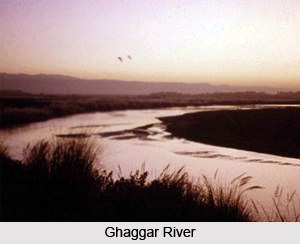
Geography of Fatehabad District also includes river system and water resources. Ghaggar, the largest seasonal stream in Haryana, enters the district as deeply incised alluvial channel and makes an exit little to the west of Fatehabad tehsil traversing around 70 kms. The river remains generally dry in summer. Hard rock geology of Fatehabad District is concealed under alluvial and Aeolian deposits. Kanker occurs at several places in the sandy tract of the district. It is used as a building material. The forests of Fatehabad District fall under the category of tropical desert thorn. Flora is scanty and sparse.


