 Geography of Viluppuram district is very favourable with a moderate temperature. The climatic condition of the district of Tamil Nadu state is fairly dry. The district of Viluppuram spreads over an area of 7222.03 hectares. The district was carved out from the South Arcot district on the 30th of September 1993 and was renamed as the Viluppuram district. The remaining portion of the erstwhile South Arcot district was given the name of Cuddalore district. The district of the south Indian state of Tamil Nadu is having its border as the Cuddalore district to the East and South, while the western part of this district is having its border as Salem and Dharmapuri district and to the northern portion by the Thiruvannamalai and Kanchipuram district.
The district of Viluppuram enjoys a suitable climate with moderate temperature. Viluppuram does not get heavy rainfall with the exception of the Marakanam and the Vanur blocks, while in the Kandamangalam and the Koliyaur blocks, the rainfall received is moderate. The rainfall received in Kallakurichi and Sankarapuram is very scarce. The normal yearly rainfall in this district is 1030 mm.
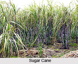
The primary food crops of the district of Viluppuram are cholam, paddy, ragi, cumbu, redgram, horsegram, blackgram and varage. The most prominent cash crops of this district are sugarcane, cotton, groundnut, coconut and casurina. This district of Tamil Nadu has a coastal length of about thirty two kilometers in Vanur and Marakanam blocks in the Bay of Bengal. There are about nineteen landing places by active fishermen population of two thousand nine hundred and eighty six. There are fishermen co-operatives societies, fisher women co-operative societies and inland fishermen co-operative societies which function very well in this district. There is also one fish net making unit in the Vanur block. There are about eighteen brackish water aquaculture farms in the district. The scope for inland fisheries in the district is somewhat limited and inland fishing is mainly carried on reservoirs and tanks owned by the Public Works Department.
This article is a stub. You can enrich by adding more information to it. Send your Write Up to content@indianetzone.com


