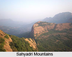
 Geography of Pune district covers a large area. The district of Pune, located in the state of Maharashtra, covers a total geographical area of 15.642 square kms. Being the second largest district in the state, it covers 5.10 percent of the total geographical area of the state. It is located between 17 degrees 54 minutes and 10 degrees 24 minutes north latitude, and 73 degrees19 minutes and 75 degrees 10 minutes east longitude. The district is bordered by Ahmednagar district on the north-east, Solapur district on the south-east, Satara district on south, Raigad district on the west and Thane district on the north-west. The landscape of Pune district is distributed triangularly in western Maharashtra at the foothills of the Sahyadri Mountains and is divided into three parts: Ghatmatha, Maval and Desh.
Pune district forms a part of the tropical monsoon land and therefore shows a significant seasonal variation in temperature as well as rainfall conditions. Climate of the western region of Pune is cool whereas the eastern part is hot and dry. Owing to the geographical conditions within the district, the rainfall is unevenly distributed. The western part of the district adjacent to the west coast is a hilly area having forest cover, due to which the rainfall intensity is more in this area as compared to the eastern parts. Most of this rain is brought by the southwest monsoon winds during the summer and about 87 percent of rainfalls occur during the monsoon months. The monsoon arrives in the month of June, with the maximum intensity of rainfall during the month of July and August.Talukas falling in the highest rainfall intensity zone are Velha, Mulshi and Maval. Falling in the moderate rainfall intensity zone are Bhor, Ambegaon, Junnar, Khed, Haveli, Pune city and Purandar. Talukas with lowest rainfall intensity, the dry and semi-arid zone are Shirur, Daund, Indapur and Baramati.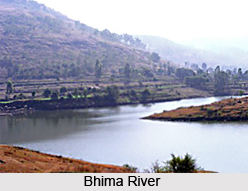
April and May are the hottest months in the district. Maximum temperature during these months often rises above 36 degrees Celsius. The western region of Pune district i.e. the talukas of Junnar, Ambegaon, Khed, Maval, Mulshi and Velha are cool whereas the eastern part i.e. talukas Shirur, Daund, Baramati and Indapur are hot and dry. December and January are the coolest months, when average temperature falls as low as 11 degrees Celsius. Humidity is low during the summer months due to increased evaporation loss from the atmosphere. The diurnal variations in humidity during this period are high, water vapour gets condensed due to falling night time temperatures and the daytime temperatures are high.
Certain natural disasters have affected the district in a rather big way in the past, especially earthquakes and floods. Due to the presence of many structured hills within Pune district, the occurrence of earthquakes take place. Fault lines are scattered throughout the district and these areas are minor earthquake prone areas. Small south-west side portions of the talukas of Bhor and Velha fall under risk zone-IV, which is high damage risk zone. The remaining part of the district falls under zone III, which is a moderate damage risk zone.
Most of the talukas in Pune district are also flood prone. The rivers likely to cause flooding are Bhima River (Taluk Shirur, Daund, Indapur and Haveli), Mula River (Pune city), Mutha River (Tal. Punecity and Mulshi), Indrayani River (Tal. Khed, Haveli and Maval), Ghod River (Tal. Ambegaon), River Mina and Pushpavati (tal Junnar), Nira River (Taluks Indapur and Purandar) and Pavana River (Tal. Haveli).
Due to heavy rainfall in the rainy season, landslide occurs in taluka Ambegaon, Junnar and Mulshi.


